Heavy Rain & Melting Snow Bring Flooding Risks This Week
Find Eric Fisher on Twitter and Facebook
As I went to chat with producers on Tuesday about what we should cover, I asked if we should give people a break for a day and talk about the milder air before really hitting on the next storm. A resounding 'YES' was the answer, because hey...we deserve it. After the coldest first week of January on record the 40s felt like May. I went iced coffee instead of hot and got a car wash like it was pollen season (alas, still salt season). But we've got a pretty potent system on the way so I hope you enjoyed the break before sloppy weather heads in our direction yet again.
There are a few headlines with this next bout of stormy weather.
First up - the warm up! We hit 43F in Boston Tuesday which was the mildest day since before Christmas (December 23rd to be exact). It'll be a touch cooler Wednesday with mid/upper 30s, but then we really kick back into high gear for the end of the week. Highs will climb through the 40s on Thursday, and perhaps even hit 50 in a few towns. We'll hold in the 40s overnight and then proceed to climb into the 50s on Friday. We may even threaten a few record highs for the date, which is a remarkable turnaround from the record cold we saw on Sunday. The highest highs may reach 55-60F.
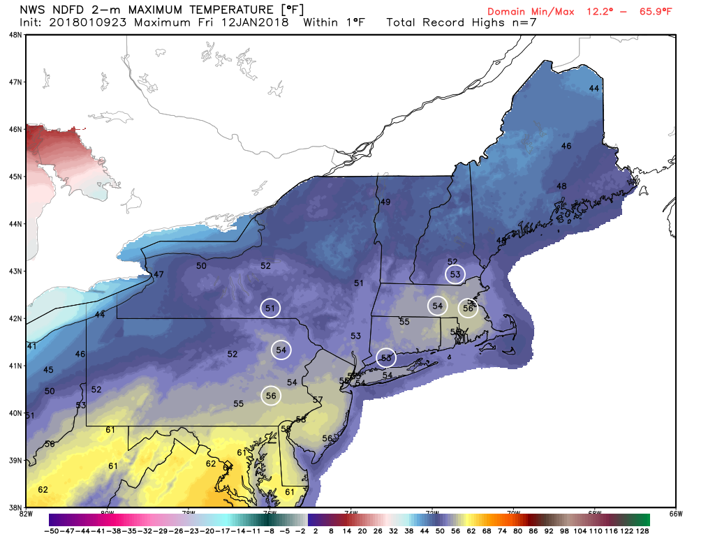
Record high potential on Friday, which should be the mildest day of the stretch
On Saturday a good portion of the region will officially spike into the 40s and 50s for highs (maybe even 60s south of the Pike?), before the colder air starts crashing back. All told this mild stretch, combined with increasing dewpoints (humidity), is going to eat up a lot of snow cover. High dewpoint air with a southerly breeze is especially efficient at depleting snow, and that's what we'll get Thursday night through Saturday morning. This process also makes for a lot of fog, which could become locally dense. Friday night will likely see pure pea soup conditions across the area with some hazardous travel.
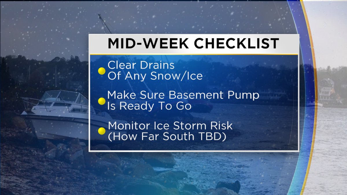
Next up - the rain! And there will be a lot of it. All guidance is pointing toward an unusually tropical air mass developing for mid-January, peaking Friday into Saturday. We will get two rounds of heavier rain with some breaks between them. The first is during the day Friday during which we could even get some thunder to mix in with the downpours. When you combine all the rain with the melting snow, you're going to get a total mess. Standing slush and water is going to be a problem, and you're going to want to keep an eye on the basement. Anyone prone to flooding could certainly get it Friday into Saturday. We should also keep tabs on our rooftops, which can become loaded with heavy dense snow as it soaks up the rain. Leaks in roofs and where ice dams develop will be a problem to monitor.
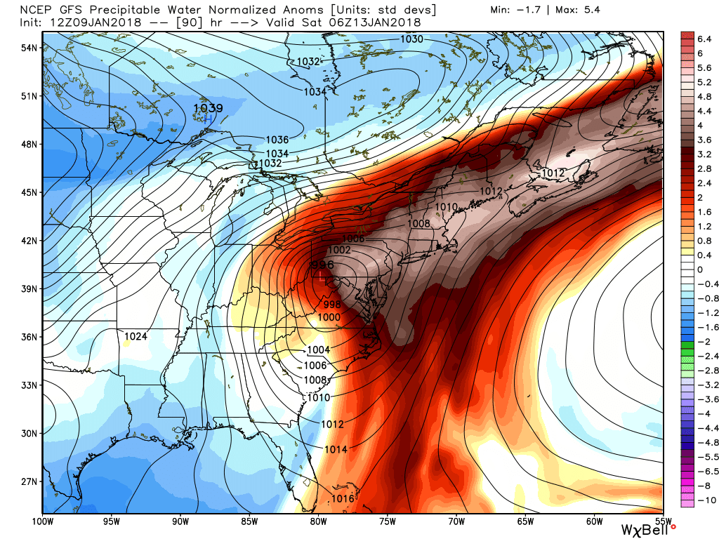
This product, precipitable water anomaly, shows how unusually moisture-laden the atmosphere will be for this time of year. The result could be some very heavy rainfall and a flood risk.
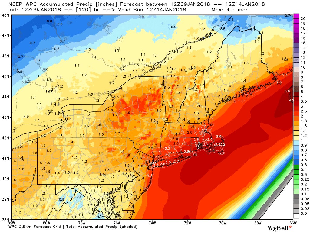
The second round of rain comes on Saturday as a stronger wave of low pressure pushes up across New England. We'll be right along the warm front, where the heaviest rainfall is likely to happen. All told it looks like a widespread 1-3" of rain with some 4" totals not out of the question. So nearly a month's worth of rain, plus a ton of melting snow to boot. That's a lot of water to handle at once.
We'll also need to watch for ice jams causing backups on waterways with the mild air and rain eating away at iced up rivers and streams. So there are a whole bunch of different things to be watchful for when it comes to water this weekend.
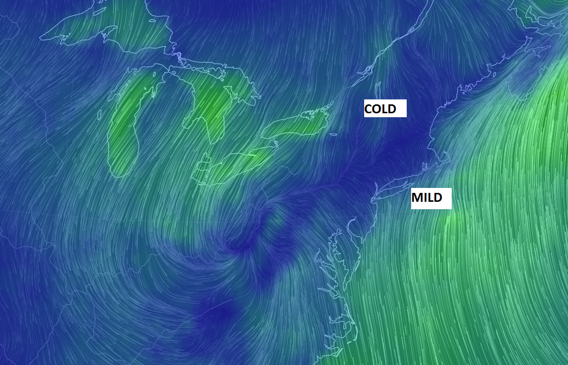
Ice Storm potential? Yes, that's also an issue for New Englanders with this setup. Friday is pure rainfall all across New England. But as we head into Friday night, a front will buckle south and start allowing colder air to seep down across the region at the surface. Meanwhile, it will still be very mild aloft. That's a recipe for freezing rain and sleet. Below you can see how we straddle the line between mild air holding court along the South Coast and colder air fighting down from Canada.
The biggest question is how far this front will buckle on Saturday and if it will be cold enough at the surface for a significant ice storm. Odds currently favor central and northern New England for the worst of the icing, but we may see the mix get as far south as the Mass Pike on Saturday. This should become more clear over the next day or two. The position of cold high pressure isn't ideal for a big southern New England ice event because it is more to the northwest of the region, instead of to the north-northeast. Our biggest cold air damming situations and ice storms happen when the high is positioned around Maine or just north of Maine, locking cold in place while mild air overruns it. With this setup, you get back edge of the front icing instead which may favor New York/Vermont/New Hampshire for the highest freezing rain risk.
For all the Pats fans, we should be safe from ice in Foxboro where it'll be warm enough for regular rainfall. A nasty afternoon for tailgating but the rain should at least wrap up by kickoff with lingering fog. Daytime highs may reach the 50s again in Foxboro before cooling off into the 40s and eventually 30s during the game.
On a final note, this setup pretty much stinks for ski country during the busy MLK Weekend. Just about all of New England will get in on the rain Friday, and northern New England will be looking at an icy mix on Saturday. We may wrap up with some trailing snowfall at the end of it, but not an ideal storm situation for the snow lovers. At least it will get colder on Sunday and Monday so the snow guns will be back in operation.


