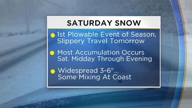
First Plowable Snow Of The Season
Updated: Dec. 8 at 11:40 a.m.
BOSTON (CBS) -- Grab the shovels from the basement and gas up the snow blowers - winter is about to arrive!
It's been about 250 days since our last shovel-able snowfall, since our last white-knuckle ride on snow-covered streets,but we hardy New Englanders never really forget.
It's like flipping a switch. One day you're walking along the beach, warm sand in your toes, and then, before you know it, you're layered head to toe in winter gear with shovel in hand ready for battle. The enemy. . . a legion of millions, no billions, make that TRILLIONS of tiny six-sided white crystals determined to break your back, one flake at a time. Luckily, we have great reconnaissance (most of the time), and it appears as though the first wave is on the way.
Before we go any further, let me just state for the record, I am not a snow-hater. In fact the first snow can be quite beautiful and exciting! Not to mention the sheer joy it brings to most kids and skiers. Whether you are a snow-lover or a snow-hater or somewhere in-between I think most of us would admit that there is something special about that first snowfall. So without further ado, let's dive right in!
TIMELINE:
The first flakes will actually be mixed with rain drops along the South Coast. Early Saturday morning a band of precipitation will push onshore. By 7 a.m. Saturday it will likely be a mix of rain and snow on Cape Cod, the Islands and parts of extreme southeastern Mass.
Between 7 a.m. and noon the precipitation field will expand over most of southern New England. For interior locations (away from the immediate coastline) it will fall mainly as a light snow. Some mixing is likely along the immediate shoreline, especially the South Shore, and more rain than snow is likely over the Cape and Islands. About an inch of snow accumulation is expected south of Boston (inland locations) by midday Saturday…not much to the north yet.

The intensity of the snow picks up Saturday afternoon, switching from light to moderate at times. It will be snowing over most of the area, back through Worcester County and southern New Hampshire. A wetter snow or mix remains likely along the immediate coastline (especially the South Shore, Cape and Islands).
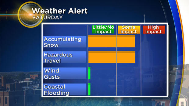
The majority of the snow accumulation happens between noon and 8 p.m. Travel will become hazardous by Saturday evening, most roads becoming snow covered. Yes, this will be plowable in most locations.
Saturday night, the snow begins to taper off, pulling north into Maine. As slightly colder air is drawn in on the backside of the storm, the rain/mix at the Coast and Cape will likely change briefly to all snow before tapering off overnight. The last of the snow accumulation will occur in northern Mass. (places like northern Middlesex County and Essex County) and in New Hampshire. An additional inch or two is possible after 8 p.m. in these locations.
By Sunday morning, there are pockets of sunshine and just a few leftover flurries here and there, stick a fork in it.
HOW MUCH:
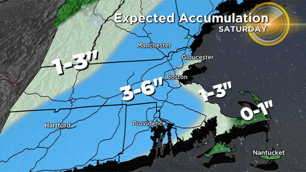
A widespread 3-6" of snow is likely for much of southern New England, away from the immediate coast.
The plows will be out… your shovels and snowblowers will be put to use. The snow won't be really fluffy, but it won't be cement either. Kind of your typical run of the mill consistency – decent snowball making snow!
At the coastline, amounts will be somewhat lower, generally 1-3". Over the Outer Cape and Nantucket, expect as much as an inch in a few spots.
OTHER CONCERNS, WIND ETC:
Thankfully, the only hazard from this event appears to be the snowfall. Very little coastal concerns here. Winds may gust 20-30 mph over southeastern Mass., especially Cape Cod and the Islands Saturday afternoon and evening. No wind damage is expected. There could be a few gusts 30-40 mph on the very Outer Cape and Nantucket. Astronomical tides are gradually lowering (from very high levels earlier this week) and with very little wind, we do not anticipate any coastal flooding issues.
With the event still a few days away, as always, we encourage you to stay tuned to updated forecasts on WBZ-TV and CBSBoston.com.
Follow Terry on Twitter @TerryWBZ


