Stormy Sunday Night, Damaging Winds And Flash Flood Threat
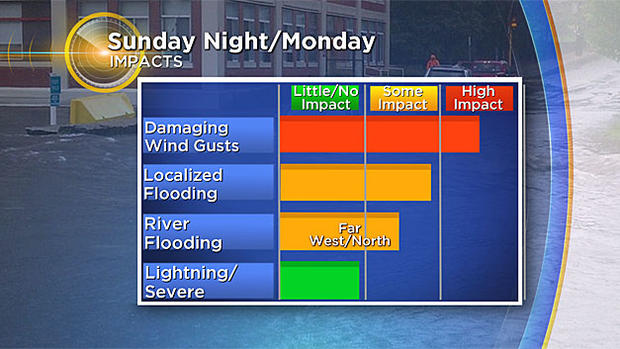
BOSTON (CBS) -- Details are coming together for our next big storm. Watches & warnings are already out to help you prepare. Sunday night through Monday afternoon, the wind and rain will give us several storm threats…the highest impacts will be from the damaging wind and flooding rain.
Wind:
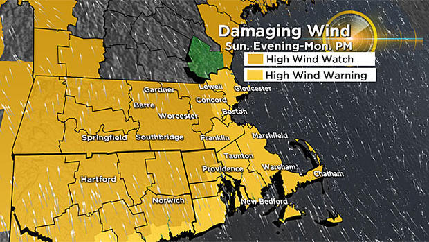
A High Wind Warning will be in effect for the MA coastlines, Cape & islands, all of southeastern Massachusetts and Boston, out to Route 128. This goes into effect 6 p.m. Sunday to 6 a.m. Monday, where we may get 65+ mph gusts. A High Wind Watch is up for all other parts of MA, CT, RI, the NH coast and ME coast for Sunday evening to Monday afternoon. Gusts will be just a tad lower here, but still strong.
We have a couple wind damage time-frames from Sunday evening/overnight and again Monday.
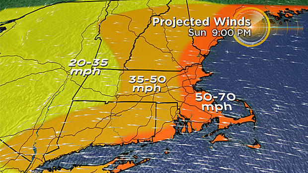
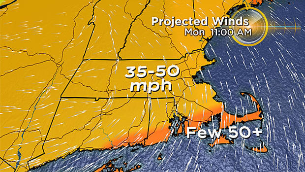
Sunday evening the wind will be from the east, southeast. Gusts of 50-70 mph are possible across the coast, Cape & islands. Outside of Route 128, gusts 35-50 mph are possible due to the friction between the wind and land. The coastal low-pressure system will move north of us Monday, allowing for a wind direction change, coming from the south. Gusts then will be 50+mph on the south coasts, still 35-50mph elsewhere. Scattered power outages are likely, as well as tree damage. The ground is very saturated so it won't necessarily take a strong gust to topple trees.
Rain:
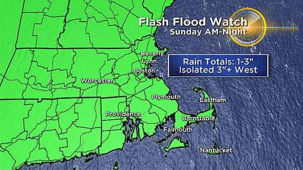
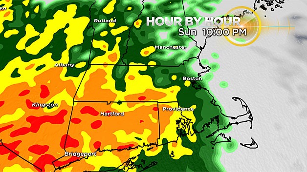
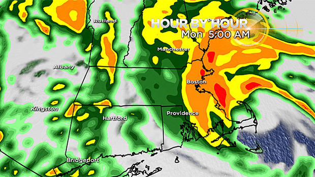
Heavy rain will spread across New England from west to east Sunday. Steady rain reaches our viewing area by Sunday evening (after the Patriots game!). Then the rain won't stop until Monday morning. Could get an isolated thunderstorm embedded within the rain too. When it's all said and done, we may get 1-3" widespread rainfall in a short timeframe. Some spots in western MA could see 3+" (that's the most likely area for minor river flooding). Localized flash flooding is likely…in fact, it will be more widespread across New England. That's why the National Weather Service has issued a flash flood watch from Sunday morning through Sunday night. Keep in mind that the falling leaves have created a cover across storm drains. Make sure they're clear of debris-this will lower your chance of street flooding and help us all out!
Timeline:
The forecast models are wobbling on the track Saturday evening. However, the timing is consistent with previous weather blog discussions and western Mass is still the area that should get the highest rain total.
Sunday morning the steady rain will stay away from Boston and Foxboro leading up to the Pats game. Clouds thicken, we have a strong south, southeast wind and temps in the mid-60s all day.
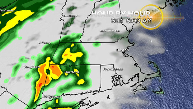
Rain spreads across the region from west to east. The heaviest rainfall in western Massachusetts.
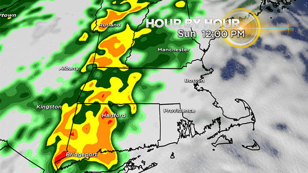
Rain will then approach Boston. This particular model run has the rain a little farther west, so take this image with a grain of salt.
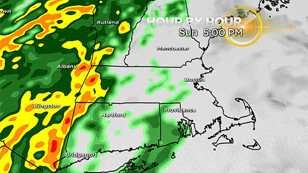
The wind will be cranked up by evening and the buckets of rain will fall. There will be torrential downpours Sunday night through Monday morning.
On Monday afternoon, our system moves out. The wind will flip direction, coming from the west, temps slowly fall and the sky gradually clears.
Coast/Marine:
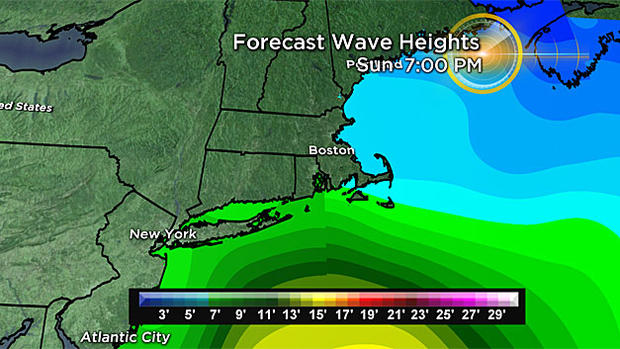
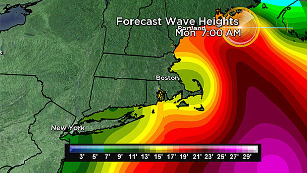
Anyone taking a ferry will need to do so as early as possible Sunday. Seas will become too dangerous by Sunday evening in southern waters. By Monday morning, waves heights offshore build to 15-20 feet across all waters east and south of New England.
Our high tides are astronomically low, thank goodness! So even with a 1-3 foot surge, worst case scenario is that coastal communities may get some splash-over. High tide is around 7 p.m. Sunday and 7 a.m. Monday in eastern and southeastern Massachusetts. High tide is around 4 p.m. Sunday and 4 a.m. Monday for southern Rhode Islands and southern Massachusetts.
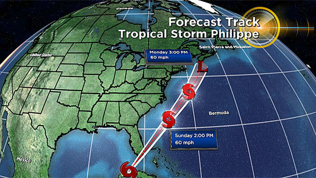
Tropical Storm Philippe
We have another tropical storm named…Philippe (pronounced as fee-LEEP, according to the National Hurricane Center). Other than helping to eject more tropical moisture into our system, this storm will not be an issue for New England as it tracks to our east on Monday.
Follow Pamela Gardner on Twitter @PamelaWBZ4