Weather Alert: Sunday Storm To Bring Damaging Winds & Heavy Rain
Find Eric Fisher on Twitter and Facebook
One storm gone, another on the way! A quiet fall is giving way to autumn gales and this weekend's storm should pack a little bigger punch than the one which wrapped up on Thursday. More mild air, wind, and rain will head in on Sunday as a potent coastal storm climbs the eastern seaboard. Here's a look at the ingredients and the timeline.
 Tropical Disturbance That May Become Philippe
You're probably going to hear about something in the tropics in the next day or so. It's true that we may briefly get Tropical Storm Philippe near Cuba, but it's not a major part of the equation for us. It basically brings some heavy rain and gusty winds to Cuba and Florida, and then gets absorbed into our developing system. End of story. So the takeaway is that we're *not* getting hit by a tropical storm, but that this blob of weather will add some tropical air to our storm ingredient list.

Looking at water vapor imagery, you can see we've got another straw brewing in the east...ready to suck up all that tropical moisture. Looks a lot like earlier this week, in fact! (also seen in the Atlantic) But instead of the stalled out meandering nature of this week's storm, this one is much more dynamic. It's moving faster, it has more mojo working for it, and will bring a more potent wallop as it races through Sunday night.
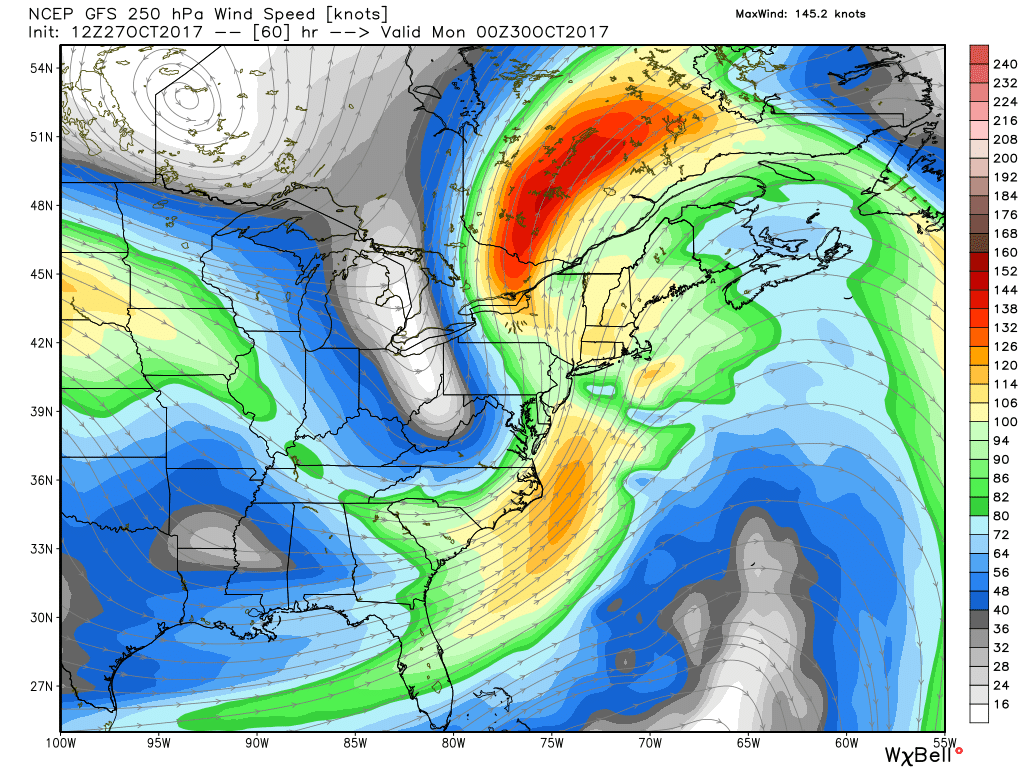
A coupled jet streak signature will help produce vigorous rising motion and a fast-developing storm on Sunday. In essence, the right entrance region of the Canadian jet streak overlaps with the left exit region of the Mid-Atlantic streak. Between the two, air wants to rise quickly and efficiently! Bombogenesis is the result.
Saturday:
Great day to clean some leaves from drains and gutters! Just what everyone wants to do on a pleasant day off. But whatever you want to do on Saturday, it'll be great out. Mild afternoon temperatures that may even reach 70F in a couple spots and dry conditions. And if you have Saturday night plans or Halloween parties, no issues at all. In fact it'll stay mild, in the 50s as clouds move in.
Sunday:
Overall, not a terrible day but not a nice one. The growing axis of heavy rain will be well to our west toward New York and Pennsylvania throughout the day. That being said, the influx of tropical air will likely bring us some scattered showers and a few downpours during the day. So if you're headed to the Patriots or elsewhere, make sure to have some rain gear with you. It won't be the main wall of water and wind that will arrive later on, so it'll be manageable throughout the daylight hours. Southeast winds will be increasing and we may start to have ferry disruption between the Cape and Islands by the afternoon.
Sunday Night:
THIS is when the storm rolls through, and for a few hours it should be a doozy. An area of low pressure will be bombing out along the Mid-Atlantic coast and taking a path north between the Hudson and Connecticut River valleys. As it rapidly develops, an arm of tropical torrential rain will lift up toward us while intense heavy rain will also focus on New York and far western New England. That's where the flash flooding risk is greatest - Vermont, the Berkshires, western Connecticut, and New York State. Our band will be moving so quickly that it will be tough to produce anything more than some flash flooding on roads, and it will be in the middle of the night. That should help lower the impact. 1-3" looks likely.
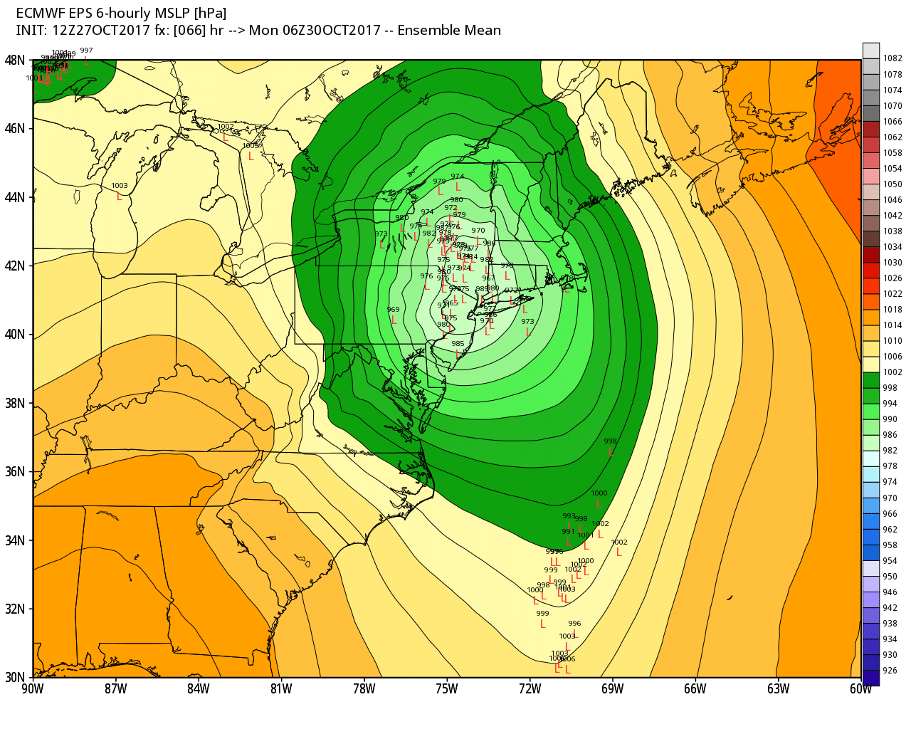
Good model support for a track to our west Sunday night
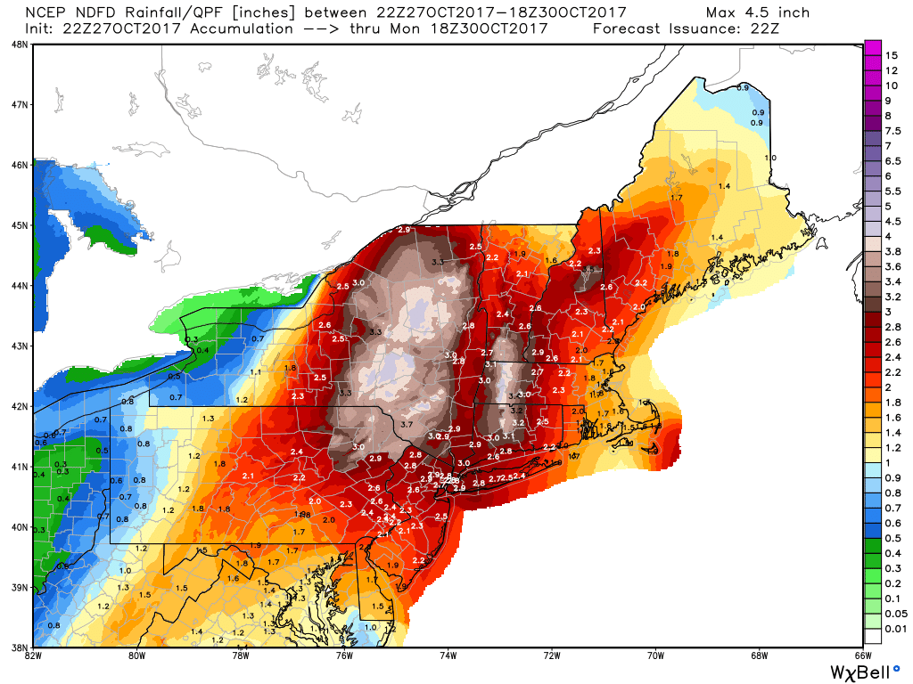
Rainfall forecast from the National Weather Service
Since we're on the east side of the storm, we're on the mild side again. Temperatures will climb into the 60s and humidity will be on the rise as well. It's also the side of the storm where thunder and lightning will be possible. And most importantly for us, the east side is where the strongest winds will be Sunday night. A powerful low-level jet will push up across eastern Massachusetts and then slam into Maine overnight. These winds are aloft, and oftentimes they don't mix down to the surface. We'll have to watch this part of the forecast carefully, but right now it looks like 50-70mph gusts will be possible across eastern Massachusetts with lower but still potent gusts inland. The highest wind risk overall is Cape Cod and the Islands, as well as Cape Ann and the Seacoast.
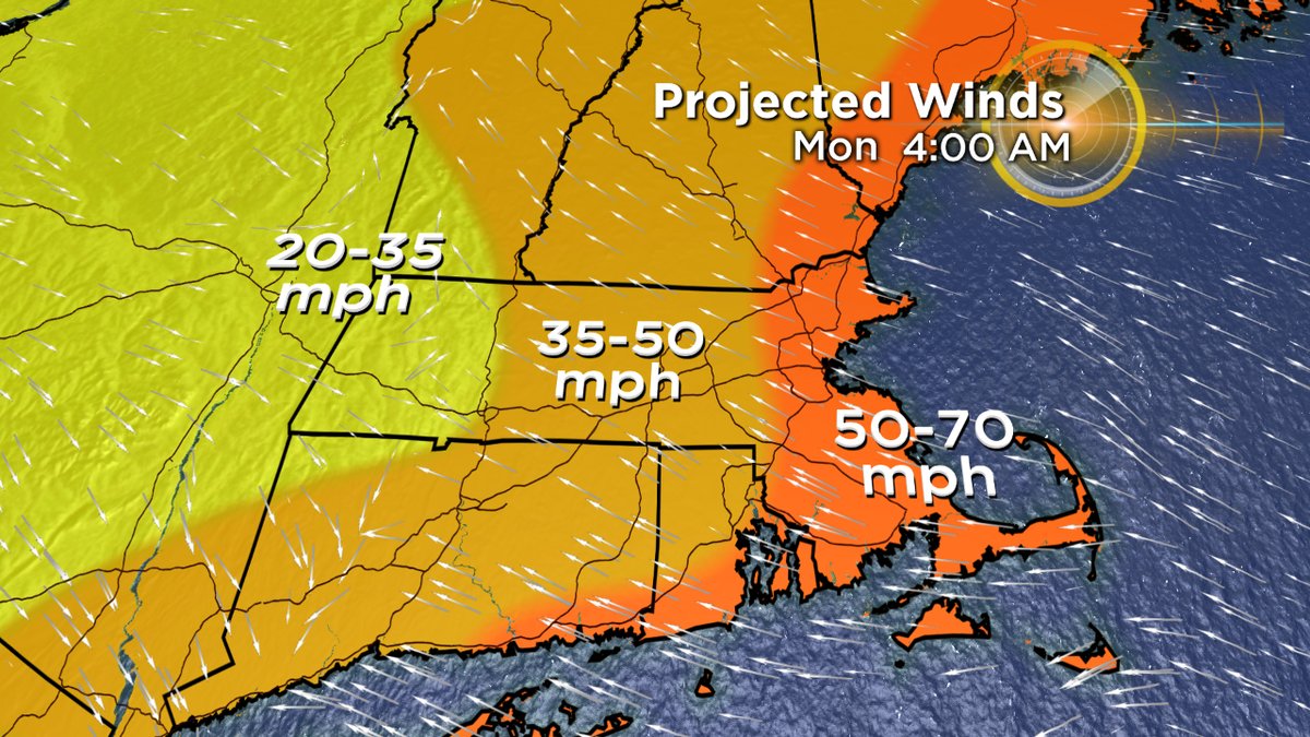
There will be about a 6-hour window, at most, that these peak gusts will be possible. It's looking like about 9pm through 3am as of this writing. Any wind gusts over 35mph are enough to take down some trees and power lines, especially since our ground is now pretty wet after a soaking rainfall. Expect power outages and downed trees Sunday night. Will be a good idea to charge anything you might want on Monday morning before going to bed, and making sure you have a backup alarm to wake up in the morning.
Some guidance is pointing to a compact ripple of low pressure to ride up along this east side of the storm and sweep over southeastern Massachusetts Sunday night. If that happens, it may help to mix down some gusts as high as 80mph in far eastern Massachusetts. Definitely worth keeping an eye on over the next couple of days to see if this takes shape.
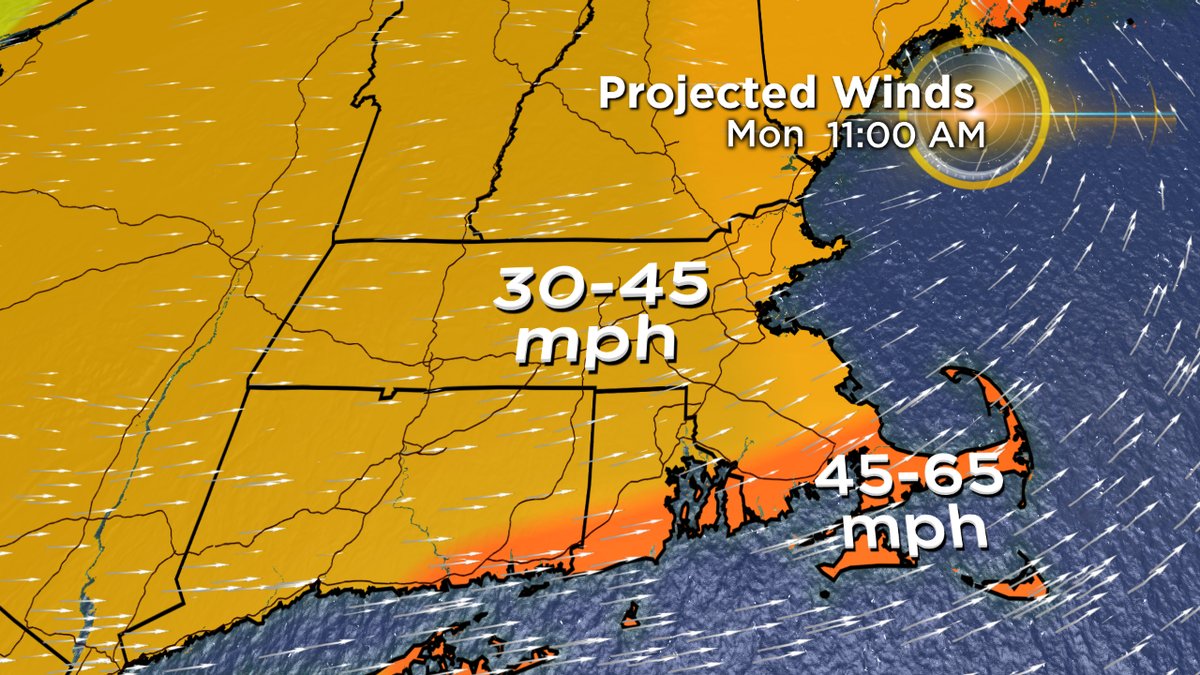
Monday:
The rain will shut off quickly late Sunday night as the dry slot races in, though there will still be some scattered showers on Monday (especially across central Mass. and interior areas). The main issue Monday is the wind. Since the low will have bombed up (quick drop in pressure) there will be a tight gradient keeping winds very strong throughout much of Monday. Region-wide gusts 30-45, perhaps even 50mph are likely...and a little higher along the South Coast and Cape. So more downed trees and some scattered outages will be likely on Monday. Temperatures will begin falling back through the 50s as the day goes on and colder/drier air moves in.
But Wait, What About Coastal Flooding?
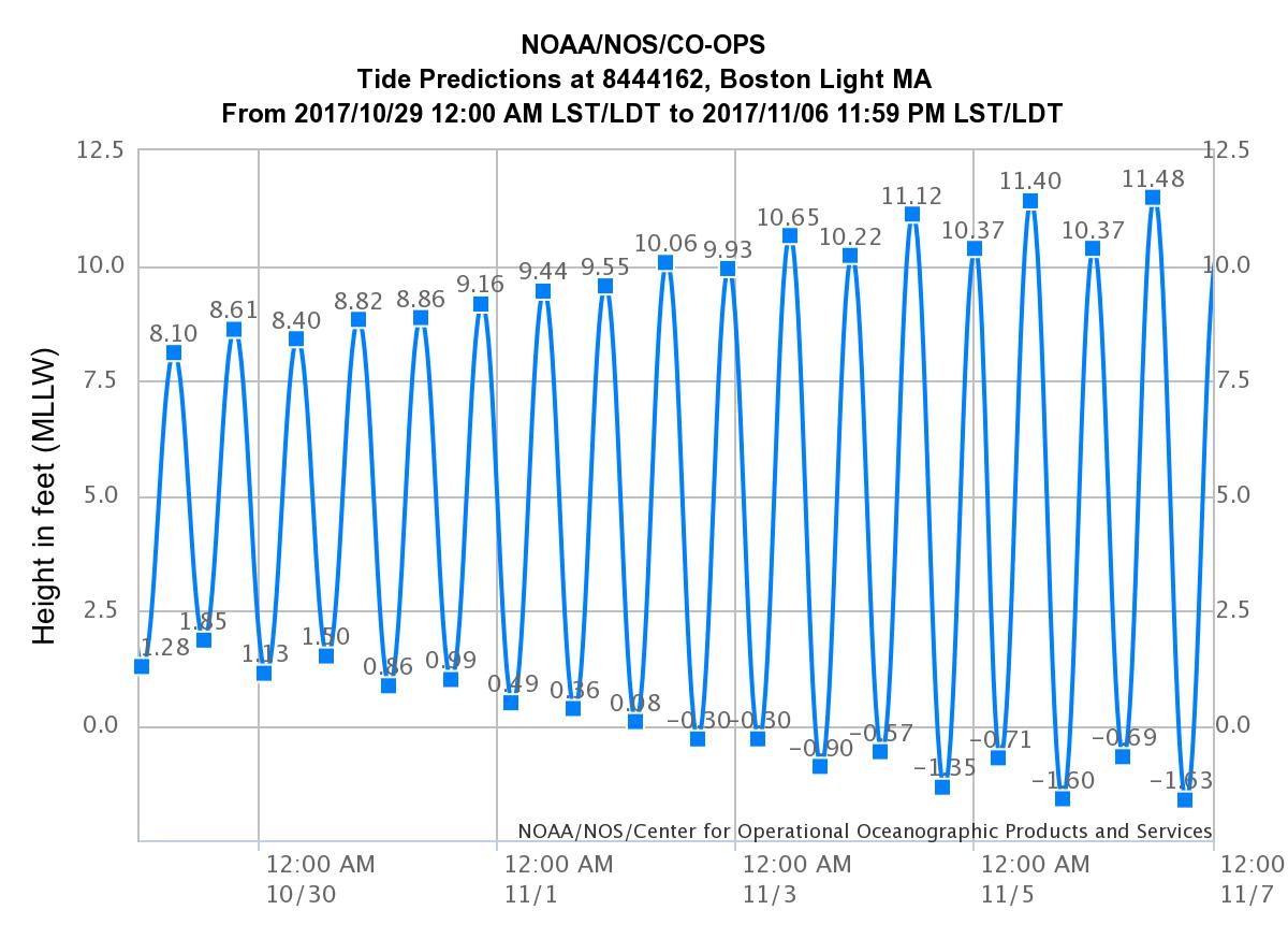
Normally with a coastal storm we talk about coastal flooding, right? Not expected to be a big issue this time. This particular storm has picked a good time in the tide cycle...with some of the lowest tides of the entire month this weekend. Plus, it looks like the brunt of the onshore winds will be during low tide of this already low cycle. AND the duration of strong onshore winds will be very brief. All those things considered, coastal flooding is not expected to be a big issue for us. Some wind-driven splashover is probably about it. Glad we're not expecting a storm next weekend when some big astronomical tides move in!