Fall Set To Make A Cameo This Week
Find Eric Fisher on Twitter and Facebook
As my wife and I strolled in flip flops and shorts to get lunch on Columbus Day, it definitely wasn't to go grab some hearty comfort food. The crock pot sits dusty on a shelf in the pantry, and the cans of pumpkin have yet to be opened. Except for a few passing days since the start of September, fall has failed to show up. Pumpkin spice investors must be losing their shirts.
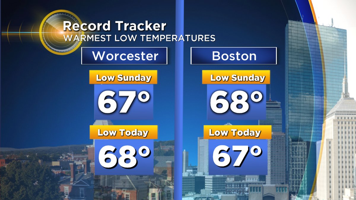
Records have been set over the past couple of days for warmest low temperatures.
It will likely come as no surprise that we're on pace for one of the warmest climatological autumns on record (September-October-November). It's been easy to forget that we should generally be in the 40s at night and 60s by day this time of year as air conditions still hang out of windows region-wide. Dew points were at or very near all-time records for the month of October on Monday (ranging from 69F-73F) in a purely tropical atmosphere that was dominating the east coast. For those getting a little sick of this, the good news is that drier air is moving in. The 'bad' news is that warmer air should keep fighting back over the next couple of weeks.
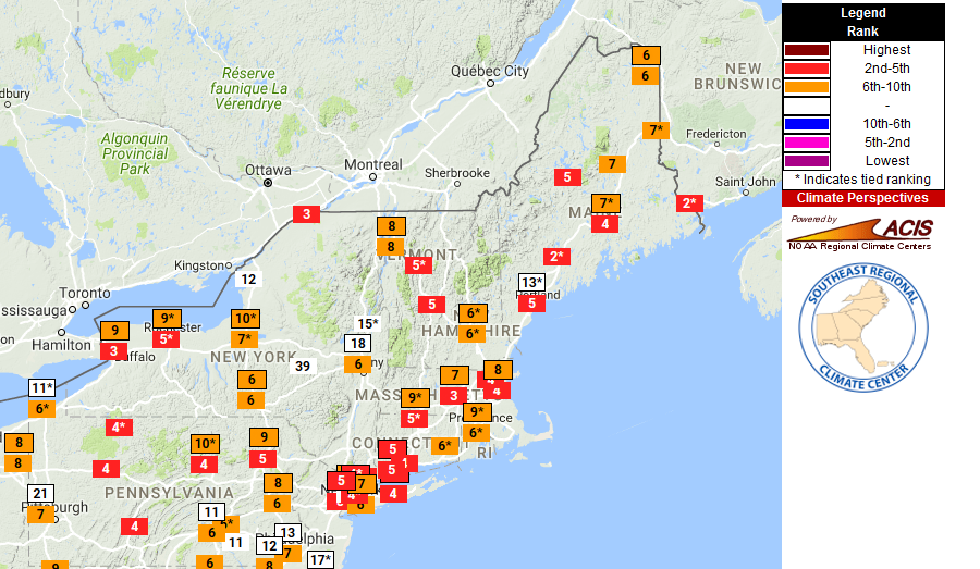
Rankings for warmest start to October (though this is only through Sunday. The positions will all move closer to warmest over the course of Monday and Tuesday). Source: SERCC
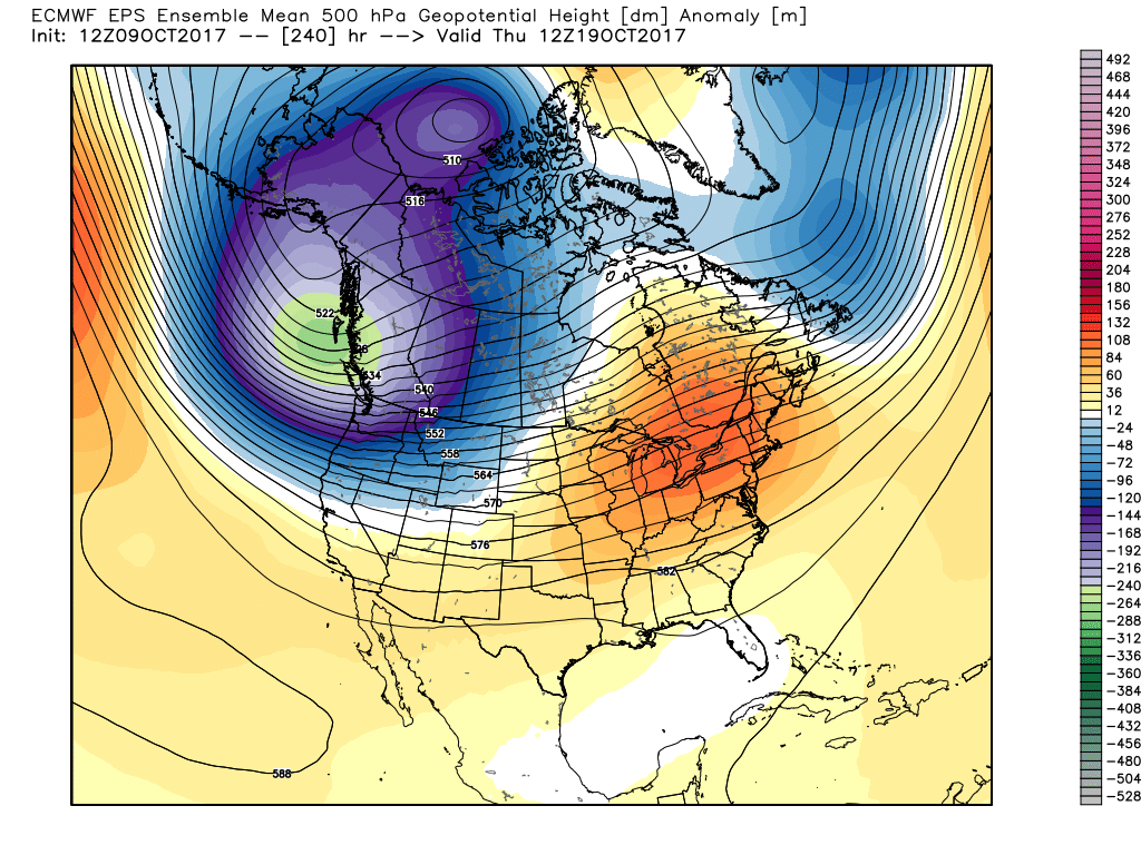
The reason for all this warmth has been an amplified pattern with a big trough in the jet stream out west and a huge ridge in the east. Snowflakes have flown early and often in the Rockies and Sierra, but it's been extended summer across the Midwest and eastern U.S. It doesn't look like this pattern is going to change much for the rest of the month. While we will get a few bouts of cooler temperatures bringing us some days back toward average, the ridge should keep fighting back bringing above average warmth. This may put us in play for a record-warm October, or at least a Top 10 finish.
Here's the timeline:
Tuesday - It gets drier, but not cooler. In fact, it gets warmer! Kicking off the day in the 60s will allow us to climb into the low 80s Tuesday afternoon, but at least the dewpoints will be falling back into the 50s. That's still going to provide a summer feel, but it won't be nearly as tropical as the past couple of days. We should stay below record highs for the date.
Wednesday-Friday - Ahhhh, autumn! We finally get a few days were it legitimately will feel like fall. Highs will stay mainly in the 60s all three days with low humidity and cool nights. There may even be a little patchy frost in the coldest pockets Friday morning. This is also a good reason to check out the foliage across northern New England ASAP. It was quite late in turning this year, and is now peaking rapidly. A couple of cold nights could allow for some quick leaf drop heading into the weekend. The next 5 days or so should be prime for these northern locations.
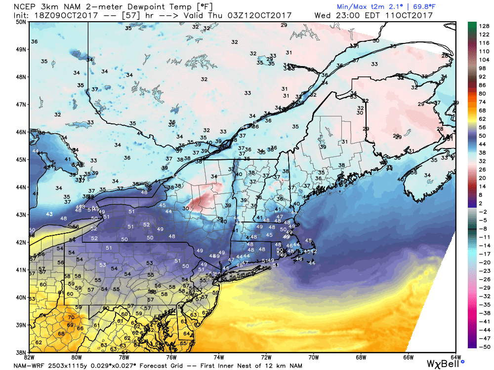
Dew points on Wednesday officially reach refreshing status.
Weekend - Here we go again! The southwesterlies should pick up again this weekend, which will bring the 70s back in play and *if* things line up the right way we may have another shot at 80 degrees in the Sunday-Monday time frame. There's going to be a warm front nearby and it's still uncertain whether our area will end up on the very warm side of it, or the cooler side of it. But certainly warmer than average for this stretch.
Next Week - While a short blast of cooler air will likely follow the front for Monday/Tuesday, it's not expected to last long. Long range guidance shows another very deep trough digging down into the northwestern U.S., which will push another large ridge up across the eastern U.S. We're losing daylight and sun angle at this point, but more 70s and perhaps even a shot at some more 80s should return to the region. So if we don't get any frost in the next couple of cool-air shots, most of the region will stay frost-free until at least the end of October.
More of the same loading up for the second half of next week. Though eventually, we may see this troughiness begin to shift east and bring the cold. Just not anytime in the next couple of weeks.


