Hurricane Jose May Feel More Like A Nor'Easter In New England
BOSTON (CBS) – It's the tropical storm that just won't die.
When Jose formed some 10 days ago, it barely got any press. At that time, it was all about Irma, and for good reason. Hurricane Jose was more of an "Oh by the way" mention at the end of the weathercast.
Well, like an unwanted guest staying late at the party, Jose has refused to give up.
It has essentially been sitting and spinning south of Bermuda and east of the Bahamas day after day, waiting for some sort of invite, some sort of direction. It now appears to have a mission and unfortunately New England may be its destination.
First off, let me say that the chances of a major hurricane strike from Jose here in Southern New England remains very low. While Jose may strengthen some in the coming days over the warm waters off of North Carolina, the ocean off of the Mid Atlantic and New England is an entirely different beast. If you've been in the ocean lately you don't need me to tell you, it is chilly! So no matter how strong Jose may get over the weekend, it is destined to take a major hit as it comes farther north and runs into water temperatures in the 60s and 70s.
In addition to that, there is no classic digging jetstream to draw Jose into New England. So while Jose may drift close to Nantucket and our coastline, it is very unlikely to be drawn inland instead a classic recurve to the east and out to sea is a much more plausible scenario.
So what does all this mean? While a direct hit from a major hurricane seems off the table right now, a glancing blow from a strong tropical/extratropical storm is very much in play. That would look and feel much like a strong nor'easter around here, certainly nothing to take lightly. There are few reasons for concern if the strong nor'easter scenario were to play out.
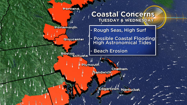
New Moon: Our tides are going to be very high astronomically thanks to a new moon next week. So it wouldn't take much wind and wave action for some significant coastal flooding to occur.
Tree Damage: With all the leaves still on the trees, this raises the possibility of tree damage and power outages. There is always more risk when the trees are fully foliated as opposed to when they are bare.
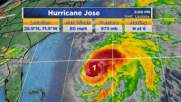
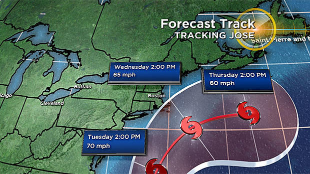
The current National Hurricane Center track brings the center of Jose about 50-100 miles southeast of Nantucket on Wednesday. Many of our models also agree with a similar track. If this were to play out, what could we expect?
WIND
Widespread wind gusts 25-50 mph in all of Southern New England. The strongest winds and most significant wind impact would be in southeastern Massachusetts and mainly over Cape Cod and the Islands. East-northeast wind gusts there could reach 60 mph or greater late Tuesday into Wednesday. This would result in significant tree damage and power outages.
RAIN
Some early, outer rain bands likely would arrive on Tuesday, spiraling in from Jose well to the south. Bands of tropical downpours would rotate off the ocean Tuesday night and Wednesday, likely leading some localized flooding. Rain amounts over southeast MA could reach 2-4" or higher in spots.
COASTAL FLOODING/EROSION
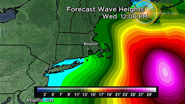
Perhaps the most significant threat from Jose comes along the coastline. The new moon will bring very high astronomical tides (high tide times are around midnight and midday Tuesday/Wednesday). With onshore winds beginning as early as Monday and increasing in strength through Wednesday, there would be several high tide cycles affected. Moderate to major coastal flooding is a possibility along with significant beach erosion. Seas would be rough all week long, peaking late Tuesday and Wednesday with 10-20 foot swells just offshore.
There is still a long way to go as of this writing, so the effects listed above are far from etched in stone. Instead they should be taken as an early warning with regards to what we may be facing next week. Never too early to start preparing, especially for coastal residents.
Stay tuned to WBZ-TV and CBSBoston.com for frequent updates over the weekend.
Follow Barry on Twitter @BarryWBZ.