Beyond The Forecast: No Way (Hurricane) Jose
BOSTON (CBS) -- "No Way Jose!"
We have just been through one of the most active and destructive stretches in recent Atlantic Hurricane history. No doubt both Harvey and Irma will be retired and the cleanup and rebuild will last months if not years.
Hurricane season, sadly, is far from over. In fact, we are just about smack dab in the middle of the peak of the typical hurricane season right now. Many of our most memorable and infamous hurricanes have come in the second half of September and even into October. And, did you know, as we speak, there is a hurricane sitting several hundred miles south of Bermuda and east of Florida?
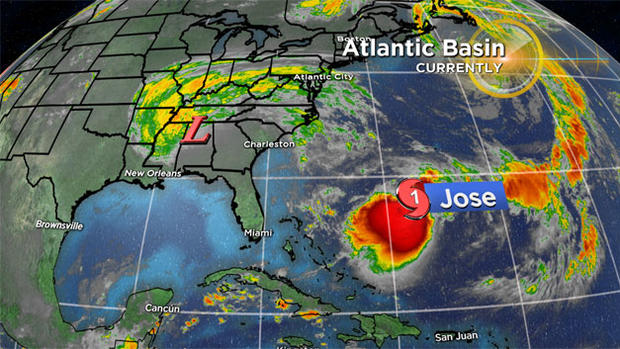
Hurricane Jose has gotten very little coverage, lurking in the shadows of Irma for the past several days. But it is there, headed nowhere fast, spinning around in circles, waiting for some sort of direction. Many times hurricanes can get caught in no man's land, waiting for an atmospheric steering current to give it a push or pull. See Hurricane Harvey--it was stuck over the Texas coast for days, leading to record rainfall and flooding.
Thankfully, this time, Jose is stuck over the open ocean and in fact will remain in essentially the same spot until later this weekend. This will also prevent Jose from significantly strengthening. Hurricanes feed off of the warm ocean waters so, when a hurricane sits in the same location for too long, there is a good deal of ocean water upwelling (cooler water drawn up to the surface). This cooler water is likely to slowly weaken and choke off the main source of energy for Jose in the coming days.
So the million dollar question--when will it finally start to move, and is there any danger to the U.S.?
Latest models are showing a west-northwest drift later this week and into this weekend (towards the Carolinas). This is typically cause for some alarm. Under the right (or wrong) atmospheric setup, a storm in Jose's position could be drawn westward, right into the East Coast.

This time around, I am happy to report that we may actually have some good hurricane news! With no big dips in the Jetstream over the East Coast to draw Jose in, it appears that Jose will be gently pushed eastward out to sea early next week. While we cannot totally rule out a track a bit closer to the coast, that scenario is becoming less and less likely.
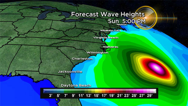
The only effect here in New England from Jose (and along the East Coast) is likely to be some rough seas. There will be some decent swells just offshore, about 5-10 feet, by later this weekend and early next week. This will likely mean an elevated rip current risk as well.
Other than Jose, there are currently no other tropical systems in the Atlantic. But like I said, we still have a long way to go. The wave train off the Coast of Africa continues to be active and unfortunately I would expect several more "named" storms before the season is done. Let's just hope that the "winds" are in our favor and the worst is behind us.
You can follow Terry on Twitter at @TerryWBZ