Beyond The Forecast: Hurricane Irma Update
BOSTON (CBS) -- Hurricane Irma made landfall at Cudjoe Key in the lower Florida Keys Sunday morning at 9:10 then made a second landfall at Marco Island in southwest Florida at 3:35 p.m. with wind gusts more than 130 mph in both areas.
One of the highest wind gusts of 142 mph was recorded at the nearby Naples Municipal Airport.
The right-hand turning of the hurricane was delayed several hours and that saved southeastern FL and the Miami area from catastrophic destruction.
Consequently, the storm surge, torrential rain, and devastating wind pummeled parts of northern Cuba and ripped across the Florida Keys then into southwest Florida.
Irma was a major hurricane for much of southern Florida but we should be so very thankful that it was not the beast that it was in the Caribbean Islands where winds of 175-200 mph occurred!
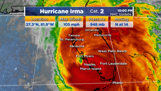
As of 10 pm Sunday, Irma was centered about 50 miles east-northeast of Fort Myers, FL. and moving northward at 14 mph. Fortunately, it will not slow down and stall like Harvey did in Texas!
Since much of its circulation is interacting with the landmass of Florida, the hurricane is in a weakening mode but it is still very powerful.
Maximum sustained winds have decreased to 105 mph. Wind gusts of 80 up to 100 mph flare out from the hurricane in a couple main bands shifting north northwestward. The spiral bands will continue to release episodes of torrential rain and produce brief spin-up twisters.
A record-breaking 56 tornado warnings have been issued today in Florida!
As the hurricane circulation tracks northward through the state, the wind direction will switch to onshore on the northern portion of the West Coast of Florida. It will produce rapid water rises as the storm surge hits the coastline and onshore winds on the northern portion of the East Coast Of Florida will pile up some areas of high water on the West Coast of FL.
Rainfall has been variable between 5 up to 15" of rain so far. The core of heaviest rain will continue to shift toward the Florida Peninsula then into Georgia and Alabama later Sunday and into Monday.
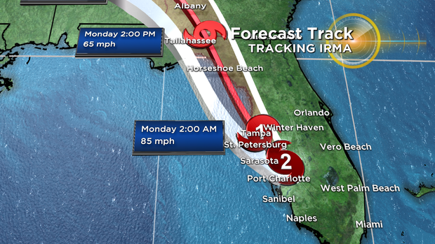
Irma will be downgraded to a Category 1 Hurricane with maximum sustained winds of 85 mph near Tampa by 2 a.m. Monday then down to a tropical storm with top sustained winds near 65 mph near Tallahassee at 2 p.m. Monday.
The remnants of Irma will likely distribute some ordinary showers with a slight breeze over parts of New England starting sometime on Thursday and lasting through Friday so we really have no worries.
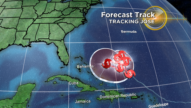
With that said, we will be closely monitoring Hurricane Jose, which is located about 400 miles northwest of the northern Leeward Islands. Jose is expected to weaken to a Category 1 hurricane in the next 48 hours and slow down and loop around over the open Atlantic.
It is unclear if Jose will have an opportunity to gain strength and track closer to the East Coast of the U.S. the first part of next week.