Beyond The Forecast: Southern New England In For Some Rough Weather
BOSTON (CBS) -- A coastal storm currently spinning off the North Carolina coastline will accelerate northeastward tonight and deliver a glancing blow to Southern New England.
The system, which had origins in the Tropics, has not officially been given a name (it would have been Irma). And, even though it is forecast to strengthen in the coming days as it races off into the Northern Atlantic, forecasters believe it will become "extratropical" and therefore never actually be a named tropical cyclone.
All semantics aside (naming and otherwise), this will be a powerful system, passing about 125 miles southeast of Nantucket early Wednesday morning.
While the majority of Southern New England will be spared any significant effects, portions of Cape Cod and the Islands will get wet and windy.
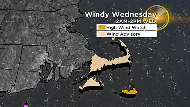
TIMELINE:
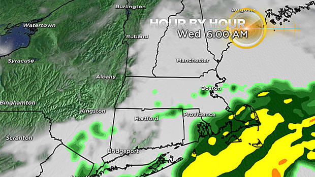
Tuesday night: Clouds thicken and rain approaches from the south. The initial batch of rain will likely get swallowed up by a layer of dry air currently overhead. Expect some light rain to arrive along the South Coast, Cape Cod and the Islands after 8 p.m.
Wednesday: The Coastal Storm makes its closest pass Wednesday morning, about 125 miles southeast of Nantucket. The shield of steady rain will likely reach as far back as Plymouth and Bristol counties, with just some light rain or drizzle farther north into Boston. East-northeast winds will peak in the morning, then shift to north-northwest by afternoon on Wednesday. Seas will be rough and the rip current risk will be very high. Sunshine returns in the afternoon as the storm races out to sea, east of Nova Scotia.
WINDS:
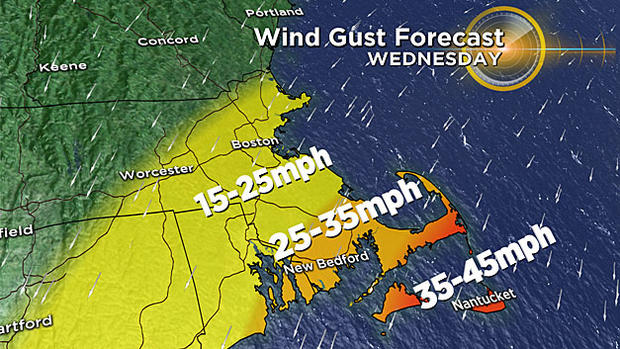
Nantucket and the Outer Cape have the greatest potential for significant wind gusts from Irma. Easterly winds 35-45mph are possible in those locations in far SE MA on Wednesday Morning.
25-35mph gusts are possible farther west near the Canal and along the South Coast and South Shore.
Little if any wind damage expected.
Winds shift to the north-northwest by afternoon.
SEAS:
Waters southeast of Nantucket will build quickly Wednesday with 10-15 foot swells. Closer to the Coastline, along the beaches of Nantucket and the Outer Cape, 5-10 ft. waves are possible. Significant rip current risk Wednesday. Tides are not astronomically high, so no coastal flooding expected.
As always, stay tuned to CBSBoston.com and WBZ-TV for updated forecasts on Irma.
You can follow Terry on Twitter at @TerryWBZ