Spring Nor'easter To Bring Snow, Sleet To New England
BOSTON (CBS) - Not up for an early spring snowstorm? Me neither.
April 1st should be about playing baseball, taking the patio furniture out of the garage, emerging from the winter cocoon, not shoveling and ice scraping! But alas, this is New England and it's all part of the experience. While the rest of the country is talking about rising pollen levels and blooming cherry blossoms, we are still battling, still fighting for every ray of sun. This is character building stuff!
So what's the latest?
A whole bunch of precipitation is on the way and it is all about the temperatures. Not just the temperatures at ground level, but for thousands of feet above our heads. A degree or two here or there will truly make a world of difference. Spring snow comes with a whole boatload of complicating factors. How much will melt on contact initially? How will the strong April sun (albeit behind the clouds) affect the precipitation type? How much will the heavy, wet snow compact?
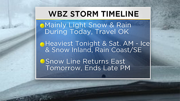
Let's break it down in pieces. This will be a fairly long duration event, starting Friday morning and tapering off Saturday evening.
Act 1: The Appetizer - Friday Daytime
The snow begins as early as 5-to-6 a.m. in parts of western Mass. and spreads east through the morning. Most of the snow which falls locally will be fairly light and non-impactful. I wouldn't expect many snow covered roads during the daylight hours of Friday.
The best chance of snow accumulation would be well north and west of Boston in the elevated areas.
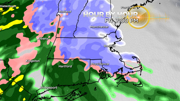
Act 2: The Main Course – Overnight Friday – Saturday Morning
When the sun goes down, things get interesting.
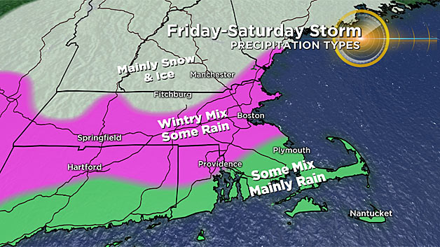
The precipitation will come down harder and it will likely stick to the ground and roads much more readily. At the same time, a nose of milder air will push up from the south and southwest, changing the snow to sleet and rain. By midnight, many areas south of the Mass Pike will be mixing and changing.
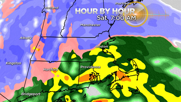
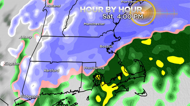
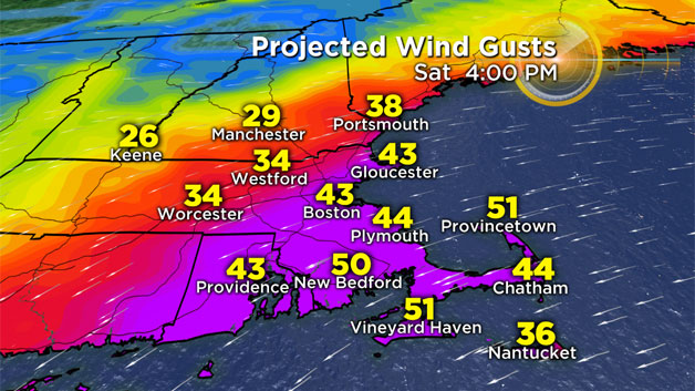
By dawn Saturday it will be raining everywhere south of the Pike while north of the Pike through the MA/NH border, the snow will be mixing with sleet and freezing rain. The winds will also be increasing out of the east-northeast, especially along the immediate coastline. Gusts 40-50 mph+ are likely over Cape Cod and the South Shore.
Act 3: Enough Already! – Saturday Daytime
The storm will linger for most of the day on Saturday. The snow will actually start to win out again and push back to the south. By early afternoon, the rain will flip back to snow in Boston and around 128 as the winds turn more to the north and northwest. It remains to be seen how much impact or accumulation will happen as the rain changes to snow, may be tough to accumulate in areas that were so wet and on the milder side.
The precipitation finally tapers off from west to east Saturday evening, but the winds remain gusty, 20-40 mph for the entire area and stronger (40-60) along the coast and over Cape Cod.
So what could go wrong?
The main thing to watch with this event is that changeover. How much of a push northward will the sleet and rain make?
If the atmosphere is even slightly colder than currently forecast, snowfall amounts could get dramatically higher. And if more sleet falls than snow, we may need to shave a few inches off current forecasts.
With an increase in snow amounts, being that it is heavy and wet, the risk for power outages grows. This could be the "X factor" with this event.
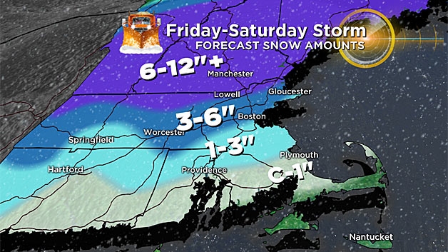
How Much Snow?
Nothing: Most of Cape Cod and the Islands…just too warm down there. Plenty of rain though.
Coating to 1 inch: Plymouth to Providence and points south to just about the Canal and South Coast. Washed away by rain in the end.
One to 3 inches: Boston and most of the South Shore (north of Plymouth), also most areas inside 495. A lot of slop here, rain, ice, snow.
Three to 6 inches: The potential exists for 3-to-6 inches of snow and sleet near and north of the Mass Pike ranging up to more than 6 inches near and north of Route 2 west of the I-95 corridor.
Six to 12 inches: Highest totals of 8-to-12 inches of heavy wet snow with some sleet over much of Vermont, New Hampshire and southwestern Maine.
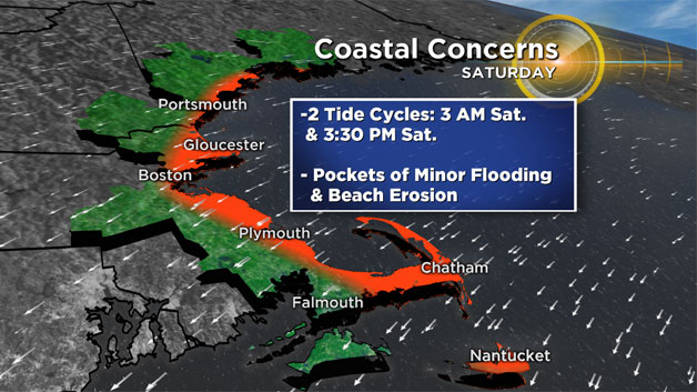
Coastal Flooding
The tides are fairly high astronomically and a persistent onshore wind will likely lead to some splash over and flooded vulnerable shore roads. Times of highest concern are the high tide in the early morning hours on Saturday (3-4 a.m.) and Saturday afternoon (3-4 p.m.).
Please stay tuned to updated forecasts on WBZ-TV, WBZ NewsRadio 1030 and CBSBoston.com. There is a fine line between snow, ice and rain. A small tweak could have BIG consequences!