Storm Moves Into New England
BOSTON (CBS) -- There are some important updates to the snowstorm already in progress.
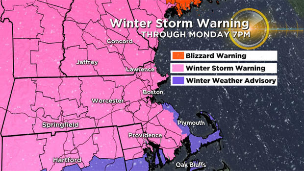
First some headlines: The majority of the snowfall accumulation will occur Sunday, tapering off after 10 p.m. Sunday as a bit of a lull occurs overnight.
The "backlash" of the storm coming on Monday is looking a bit less dire for our coastline. It now appears as though the strongest (most damaging) winds and the heaviest snow bands will occur just offshore and over the fishes.
While it looks like we will miss the strongest core of the winds Monday, there will still be gusts near the coast between 40 and 60 m.p.h. and some coastal flooding around the time of high tide (11 a.m.-4 p.m.), especially in north facing beaches (Cape Ann, Bayside of Cape Cod).
TIMELINE:
Through 10 p.m.: Snow continues steadily over most of the area falling at an inch per hour at times. Near the Coast, with temperatures closer to freezing, the snow will be much wetter and slower to accumulate. Some rain/sleet will mix in at times along the coast and in SE Massachusetts. This is when the majority of the snow accumulation will occur for inland areas.
10 p.m.-4 a.m.: A bit of a lull overnight as the center of the storm passes by. Some light snow continues inland, but not very much additional accumulation in these hours.
4 a.m.-Noon: The storm rapidly deepens off the East Coast and some wrap around (backlash) snow bands will rotate from north to south down our coastline…any rain will change over to snow as colder air is drawn in on north-northwesterly winds. Additional snowfall Monday morning will range from 4-8" in Essex County and parts of northern Middlesex County, 2-4" for the rest of the area (south and west of Essex County) as far west as Worcester. West of Worcester, very little, if any additional accumulation is expected Monday morning.
After Noon Monday: The storm pulls farther east and all that is left is some lingering snow showers and flurries along the coast, accumulation over. In fact, some peeks of sunshine are possible to the west!
FINAL SNOW AMOUNTS:
The jackpot from this storm will be up in Maine, where they are in for 1-2 feet of new snowfall!
Locally, the coastline of New Hampshire and Essex County MA will see the highest amounts (thanks to the backlash snows Monday morning)…final totals up there will likely top a foot.
8-12" is expected for all other areas north of the Mass Pike including most of Worcester, Middlesex and far western Essex counties.
4-8" in Boston and most areas south of the Mass Pike.
2-4" along the MA south coast, Cape Cod and the Islands
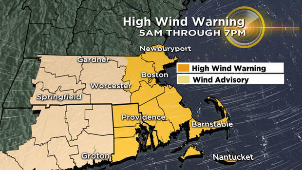
WIND & COAST:
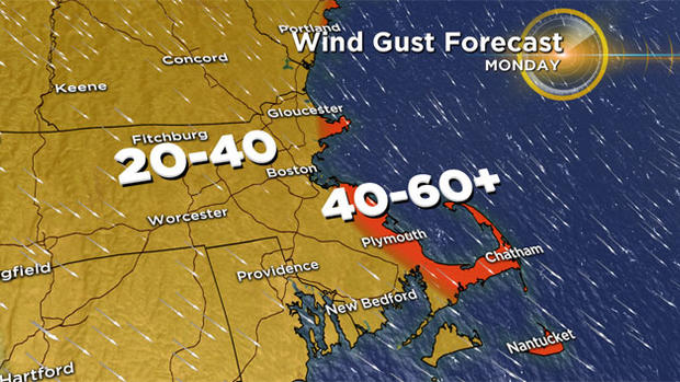
Again, the winds Monday likely will NOT reach 70+ m.p.h. as initially feared over the Outer Cape. However, we still expect gusts out of the NNW between 40-60 m.p.h. over Cape Ann, parts of the South Shore and Cape Cod/Islands. Inland areas will have NNW gusts between 20-40 m.p.h. for most of the day on Monday. Some wind damage is likely, especially in coastal locations.
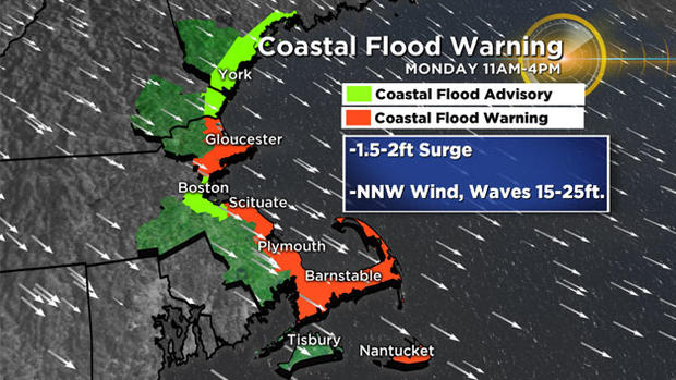
The high tide is around midday on Monday, however with the winds being from the northwest, this is an offshore direction for east-facing beaches. We are most concerned with the north side of Cape Ann and the Bayside areas on Cape Cod. There may be moderate flooding in those locations. Wave heights will grow to 15-20 feet just offshore and that alone could be enough for some splashover in typical, flood-prone areas on the MA east coast.
Keep abreast of weather updates on WBZ-TV & CBSBoston.com.


