Extremely Heavy Snow, Damaging Winds Sunday Into Monday
BOSTON (CBS) - Get ready for another round of heavy snow, changeable precipitation, damaging winds, and coastal flood threats Sunday into Monday.
A Winter Storm Warning is in effect from 7 a.m. Sunday to 7 p.m. Monday for nearly all of Massachusetts, while the coast, with the exception of Boston, is under a Blizzard Watch.
TIMING
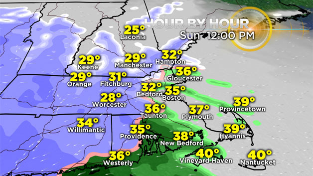
The snow begins in Worcester County between 10 a.m. and noon Sunday with a light wintry mix around Route 128, while there will be cold rain from Boston to Cape Cod.
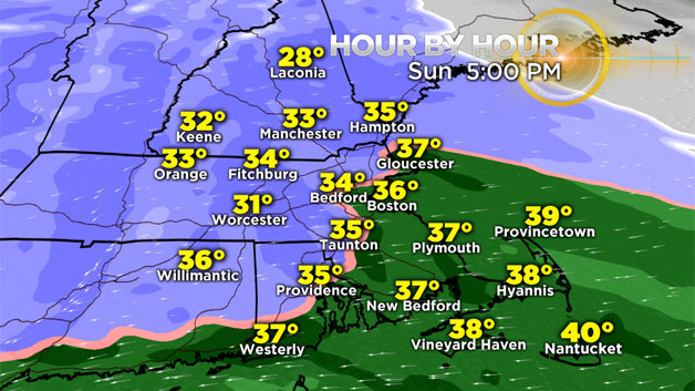
The heavy snow will continue along I-495, in northwestern Rhode Island, northern Connecticut, Worcester County, and all of New Hampshire and Vermont, eventually spreading into Maine. A wintry mix will develop in Boston, with heavy rain in southeastern Mass., the Cape and Islands.
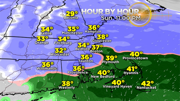
The rain/snow line will retreat slowly southeast as the low pressure center rapidly intensifies to our south. There will still be heavy rain along the south coast and Cape in the evening. It will change over to wet and pasty snow in Boston.
The heaviest snow in Boston will be overnight Sunday. Bands of heavy snow will increase the totals along the New Hampshire and Maine coasts.
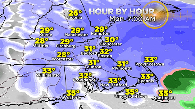
By Monday, the snow tapers off from west to east. With the last bit of snow hanging around the South Coast, Cape and Islands. All the snow moves out late Monday afternoon.
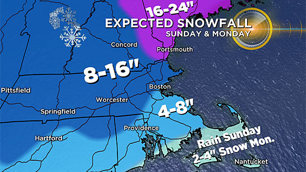
TOTALS
The tricky part here is how long the temperatures stay above freezing in Boston. That is where the dividing line is for snow totals.
The jackpot zones will be coastal and eastern New Hampshire into Maine with up to two feet of snow. Towns outside of I-95 into Worcester and along the Massachusetts Turnpike should expect 8-to-16 inches.
To the south and east of the city, 4-to-8 inches of snow will fall. For Cape Cod, Martha's Vineyard and Nantucket, it's rain Sunday then 2-to-4 inches of snow Monday.
WATCHES AND WARNINGS
The Winter Storm Warning goes into effect Sunday into Monday for Boston, Worcester, Springfield, Hartford, Providence and Concord, New Hampshire.
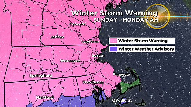
A Blizzard Watch is up for the Cape, Nantucket and across the South Shore, North Shore, Cape Ann, through the New Hampshire and Maine coastlines.
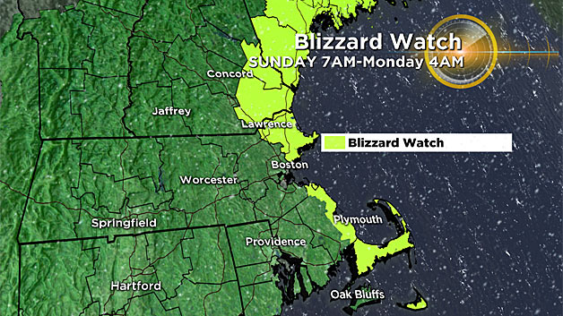
This means not only the snow, but the wind will be very strong.
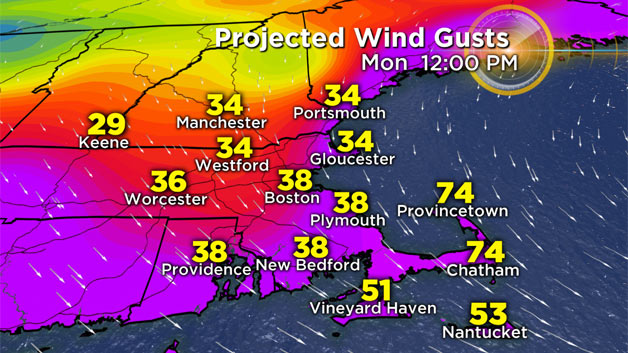
WINDS
The peak wind gusts will bring some outages and damage across the coastline. Especially for the outer Cape where wind gusts could be between 60 and 80 mph Monday afternoon.
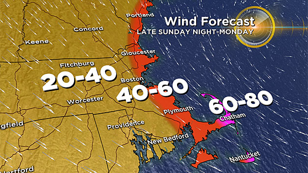
Farther inland, 20-40 mph gusts will still create blowing and drifting snow as we try to dig out from the heavy snow.
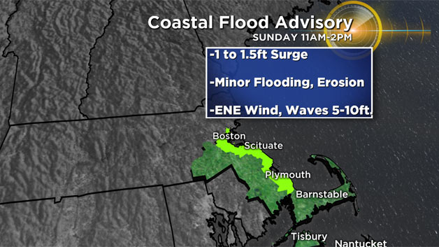
COASTAL FLOODING
The wind direction will not be from the northeast during the entire storm. However, wave heights will be high enough to create splashover and some flooding during our fairly high astronomical tides.
A flood advisory is up on either side of the noon high tide Sunday.
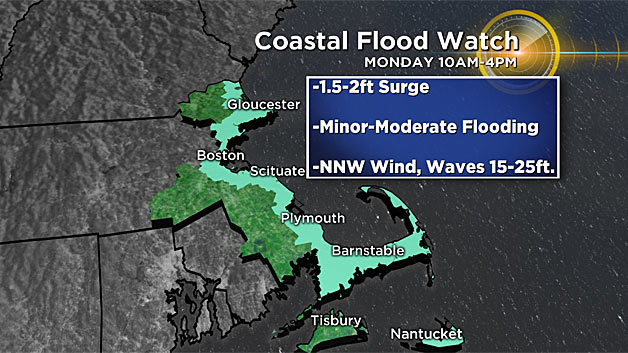
A flood watch is up for more of the shoreline for the Monday afternoon high tide. Wave heights will be much higher, but the wind direction will be more from the north, northwest.
Stay tuned to WBZ-TV and CBS Boston.com for further updates.


