Blizzard Gives Way To More Weekend Snow
Find Eric Fisher on Twitter and Facebook
Bright sunshine helped us dig out on Friday from the 8-14" of fresh snow blanketing the region. But don't put away the shovels and snowblowers. An active pattern is here and no doubt more snow will fly over the next few days. The question is how much of it will we add to the pile? Saturday morning is no big deal, but the storm Sunday morning into Monday warrants our attention. Buckle up!
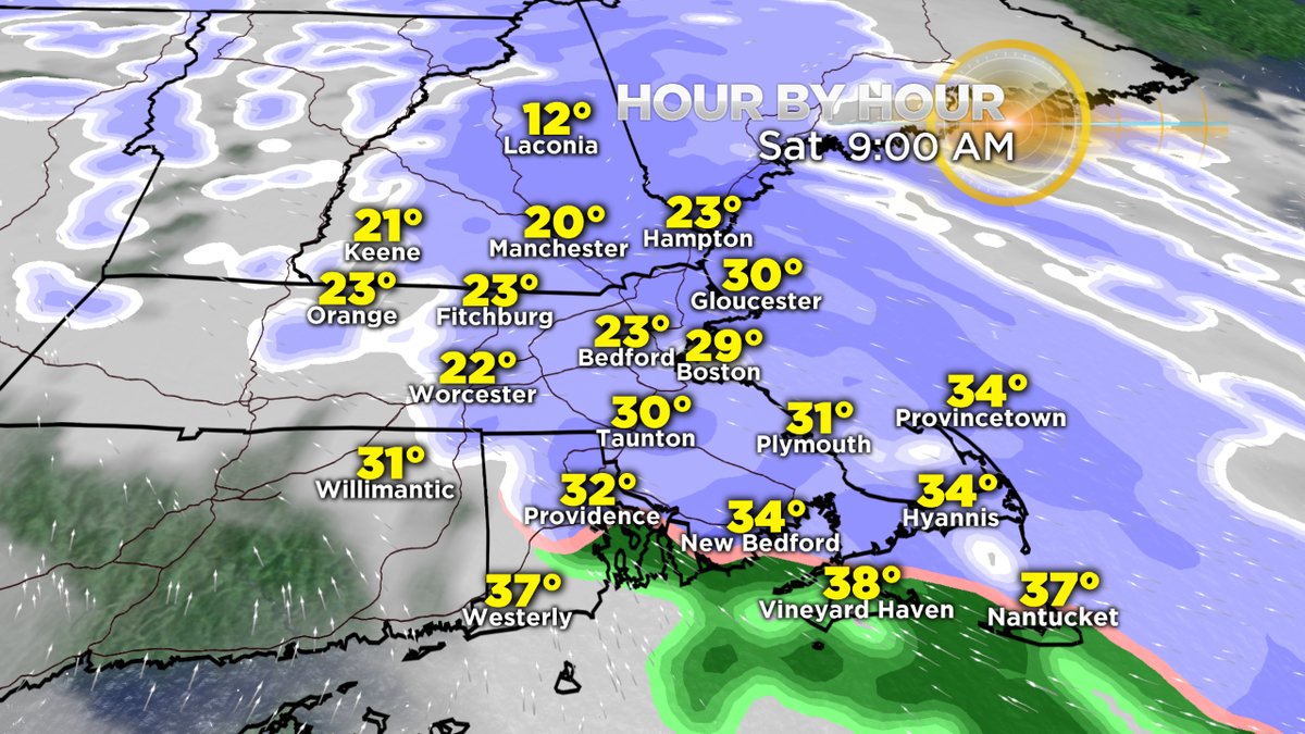
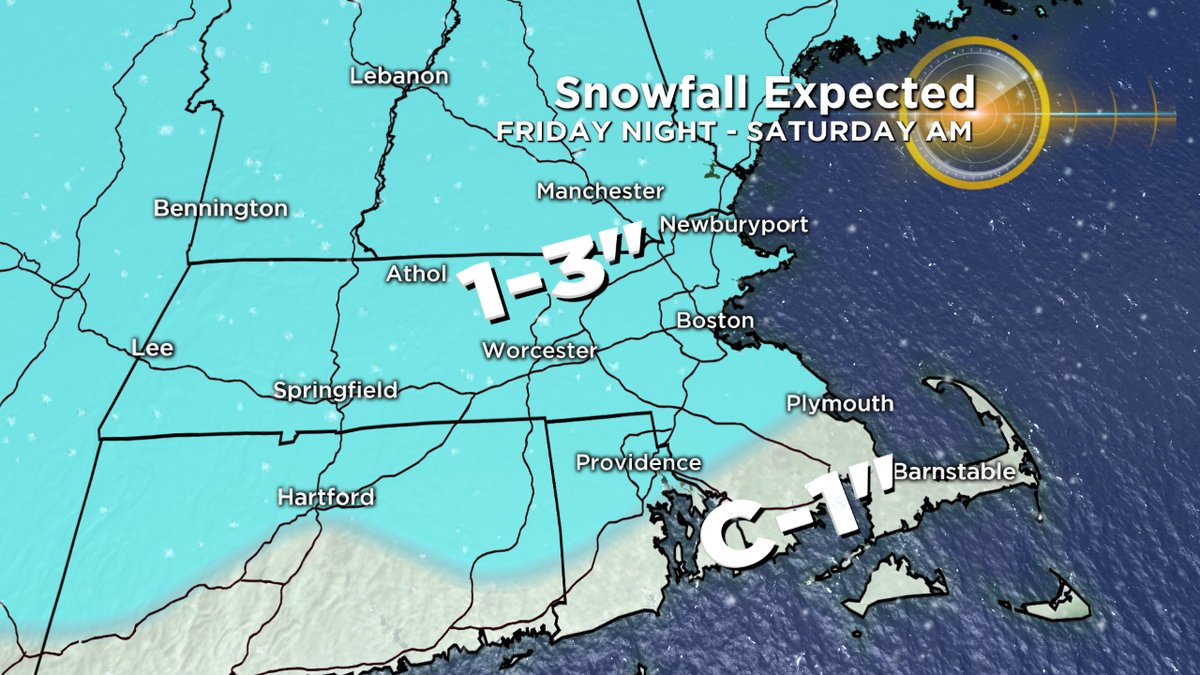
First up is snowfall Friday night through Saturday morning, which is a more straightforward forecast. Warmer air moving in from the southwest will flow over the cold locked in over New England, producing a widespread 1-3" of snowfall through noontime. A few locally higher totals near 4" are possible, mainly for the higher elevations. So get ready to hang out with some cocoa in the morning and get the kids ready to hit the sledding hills. In fact it'll turn out to be a great day for all winter sports. We haven't had many opportunities to hit the snowmobile trails or strap on the snowshoes this winter. Saturday offers the perfect day for it, with comfortable high temps in the mid 30s to low 40s. For those who get sunshine (most likely south of the Pike) it should feel wonderful out in the afternoon.
Sunday is where things get messier. It all starts with a batch of wet snow and rain developing Sunday morning. Rain will be more likely south of the Pike and toward the coast, while snow is likely across interior areas. At this point the storm isn't really 'ramped up' yet so we're not talking about whipping winds or blizzard conditions. However, travel will certainly be slow and sloppy throughout the day, especially away from the coastline. Plows will be back in action.
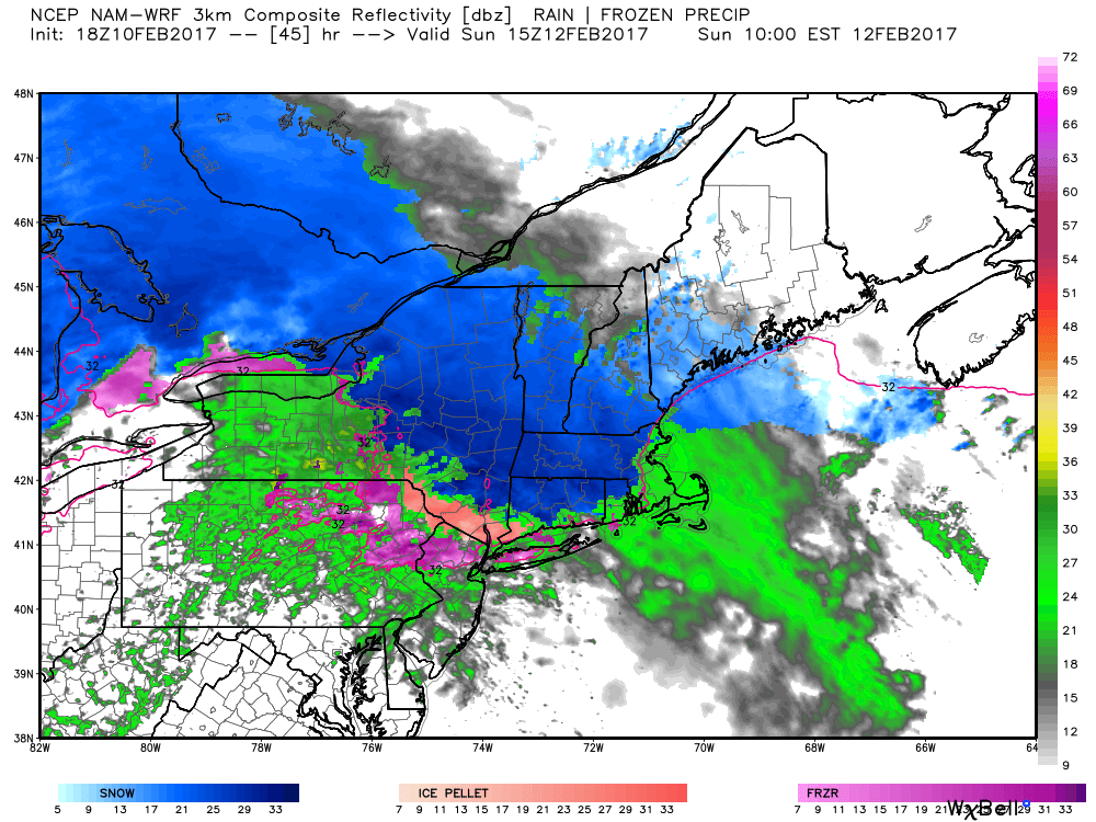
By Sunday evening, the initial inland area of low pressure will be handing off to a developing coastal low, and all indications are that this one will become a beast. If you're playing winter forecasting bingo, you can cross off 'bombogenesis.' Pressure will plummet right along the Cape Cod coastline and the storm will explode while heading toward the Gulf of Maine. If this happens on the western side of possible paths (over the Cape) then much of eastern Massachusetts will be seeing rain Sunday evening with snowfall over interior New England. If it occurs a little farther east, then we'll more rapidly switch the coast over to snow heading into Sunday night.
Right now, it looks like we could see a half foot or more of snow on Sunday, from morning through evening, across the interior. A solid addition to what's already on the ground. I'd say there are good odds of a plowable snow in Metro Boston, but the exact totals are not quite clear just yet. A range of 3-6" seems a good place to start. And it will be messy for all areas along/inside 128 as we may oscillate between wet snow and rain from morning right into the first half of the overnight. With borderline temps in the low/mid 30s there, the snow won't add up as rapidly as what we saw on Thursday.
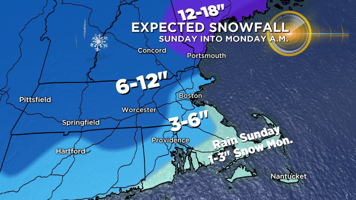
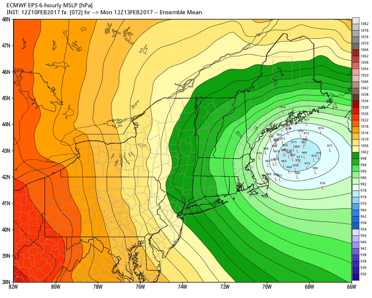
What happens Sunday overnight into Monday is the biggest question mark. Some guidance deepens the low so much that it closes off and stalls, potentially retrograding (moving west) back toward us on Monday. That solution would drag heavy snow and strong winds over all of eastern Massachusetts on Monday and dramatically increase the snow potential for the Boston area. We'd essentially drift into an all-out snowstorm. However, quite a bit of guidance is more progressive and allows the storm to pull up farther north and east by Monday with low snow amounts for eastern Massachusetts. I think we'll have a much better handle on which of these scenarios is more likely by Saturday, but it's a high stakes prediction. The closer path could make for all-out blizzard conditions again from Maine all the way down the coast to Cape Cod. The farther path gives us a very windy day with meager snow Monday. Quite a bit of difference on the line.
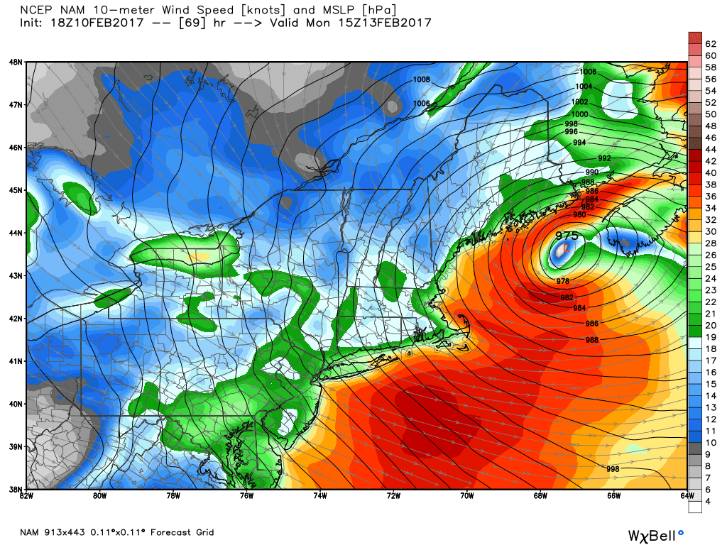
Regardless of snow totals, the wind should howl late Sunday night into Monday. Those strong winds will be out of the north, and could produce coastal flooding and outages. A worst-case (closer to the coast) storm would have the potential of wind gusts 60-80mph! Just a little farther east and we'll be more in the 40-60mph range. Either way, plenty of wind to go around and ~60mph at the coast are a solid likelihood. Astronomical tides are lowering by Monday since our full moon is happening this Friday night, but I'd be most concerned about the bay side of Cape Cod and Nantucket. There could also be a significant amount of beach erosion as the wave action increases. Lots to keep tabs on as we kick off the week.
So in summary, it's not a forecast locked in stone yet. We'll be tweaking the track, snow totals, and forecast gusts throughout the weekend. It's the type of storm you definitely want to stay updated with because I'm sure things will shift some over the next 48 hours.
To break it down by region -
Maine should get crushed with over a foot of snow and strong winds Sunday into Monday. This is where the brunt of the storm will take place.
Most of Vermont and New Hampshire receive a solid snowfall regardless thanks to snow on Saturday, over a half foot on Sunday, and then potentially a bunch more on Monday across New Hampshire if the storm ends up with the farther west track. Winter sports will be in full swing!
Connecticut, Rhode Island, and SE Mass will be on the lower end of snow totals. But we'll be monitoring the Cape, Islands, and South Shore for potential backlash snow on Monday.
The 'lowest confidence' zone is essentially MetroWest to Boston and locations northward to Essex County. A lot of uncertainty as to how much snow will fall here.


