Weather Alert: More Than A Foot Of Snow In Forecast Thursday
BOSTON (CBS) -- Here it comes - our annual February winter blitz has begun!
The trend over the last few winters has been for a quiet, relatively easy start to winter and then a short but intense period of snow and cold in February and early March. Tuesday's wintry mix will be just an appetizer to a much bigger snow event which will arrive Thursday.
How about this upcoming stretch for New England winter on steroids?
Tuesday: Rain, snow and ice
Wednesday: Highs in the 50's, some spots may nick 60 degrees falling just shy of record high temperatures
Thursday: Nor'easter with as much as a foot of snow
Friday: Windy and frigid, stuck in the teens in many areas
Sound like a 4-day forecast straight out of a Hollywood movie? Nope, that's just good ol' fashion February in New England.
Without further ado, let's get right to the main story, our Thursday nor'easter.
TIMELINE:
The snow will arrive between 5 and 8 a.m. on Thursday.
The first flakes will fall in southwestern-most New England and then fill in to the north and east. So, the early morning commute will likely be doable with very little snow accumulation before 9 a.m.
However, things will ramp up and deteriorate quickly after that with an inch-per-hour or greater snowfall rates rushing into southern New England by late morning and midday Thursday. We get several hours of steady, heavy snowfall, through the afternoon. Thankfully, this storm will keep on truckin', nothing really to slow it down or stop it from moving east rather quickly.
So by 5 p.m., there will already be a back edge to the snow visible on radar in western Massachusetts. From there, the snow will taper off from west to east between 6 p.m. and 9 p.m., with just some lingering flurries on Cape Cod after 9 p.m. Thursday.
A solid 12-hour slug of snowfall, in and out of here on Thursday.
SNOW AMOUNTS:
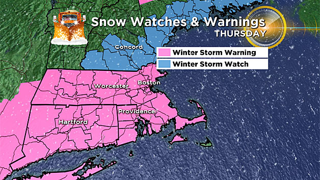
This looks like a classic southern New England bullseye.
Widespread 8-to-14 inches of snow is expected for most of Massachusetts, Connecticut and Rhode Island. Amounts taper to 4-to-8 inches in far northwestern Massachusetts and up in southwestern and central New Hampshire.
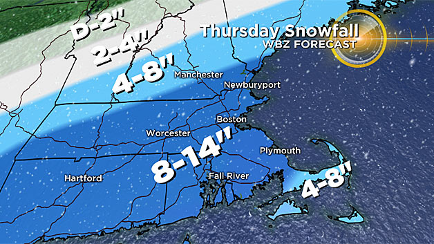
Two-to-4 inches are expected in far northern New England, tapering to nearly nothing up near the Canadian border.
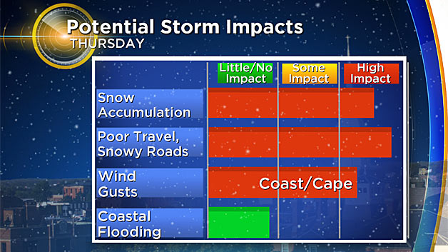
This will be a fluffy-type snow for those west of I-95 and areas north and west of Boston. The snow will be much heavier (wetter) right along the immediate coastline of the South Shore and over Cape Cod and the Islands.
There will likely be some mixing over Cape Cod and the Islands, therefore we have slightly lower snow amounts there (4-to-8 inches). At the very least, the snow will be MUCH wetter there (slop). Out on Nantucket, with a good amount of rain forecast, snow totals will likely only be 2-to-4 inches.
WIND:
This is a classic nor'easter on the way, hence the winds out of the northeast for most of Thursday, turning to the north by evening.
The strongest winds will be over the South Shore and particularly over Cape Cod and the Islands with gusts peaking between 45-55+ m.p.h. during the evening on Thursday.
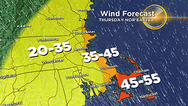
In Boston and along the coastline to the North, wind gusts will range between 35-45 m.p.h. through the day.
It will be a bit less gusty inland, however, some gusts could reach 20-35 m.p.h. away from the coast.
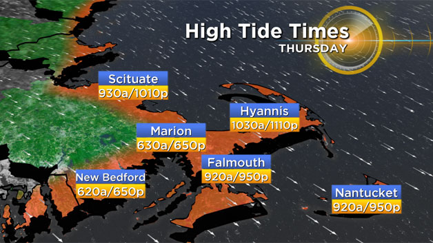
COASTAL CONCERNS:
With a full "snow" moon coming on Friday, the tides will be astronomically quite high during the storm, reaching over 11 feet in Boston Thursday morning.
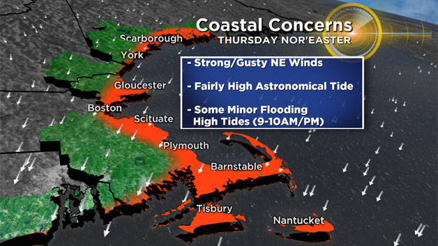
The good news here is that the strongest onshore winds with this storm will largely come between high tide cycles (Thursday afternoon).
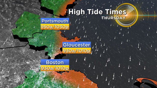
Our morning high tide is between 9 and 10 a.m. (just as the storm is starting) and our night-time high tide is between 10 and 11 p.m. (as the storm is pulling away and winds are turning northerly).
Even so, there likely will be some minor flooding and splash over Thursday night as the tide comes in.
WHAT COULD CHANGE?
It's the weather, things can and likely will change!
There is fairly good agreement at this point with our models and given that the storm is 24 hours away, I wouldn't expect any major changes, just some tweaking here and there for where the heaviest snowfall may occur.
Having said that, we got you covered as always, stick with WBZ-TV and CBSBoston.com for updates!