Winter's Back! Cold Air And Several Snow Chances Ahead
BOSTON (CBS) - If you've lost that winter lovin' feeling....it's not gone, gone, gone. We're back in the game and just in time for what's typically the busiest time of year for snowfall in the Boston area.
While the first couple of events won't be huge, they will help lay the groundwork for a colder and snowier month compared to our long January thaw. The first one starts Tuesday afternoon, another Wednesday, and another to keep tabs on to end the weekend.
Let the games begin.
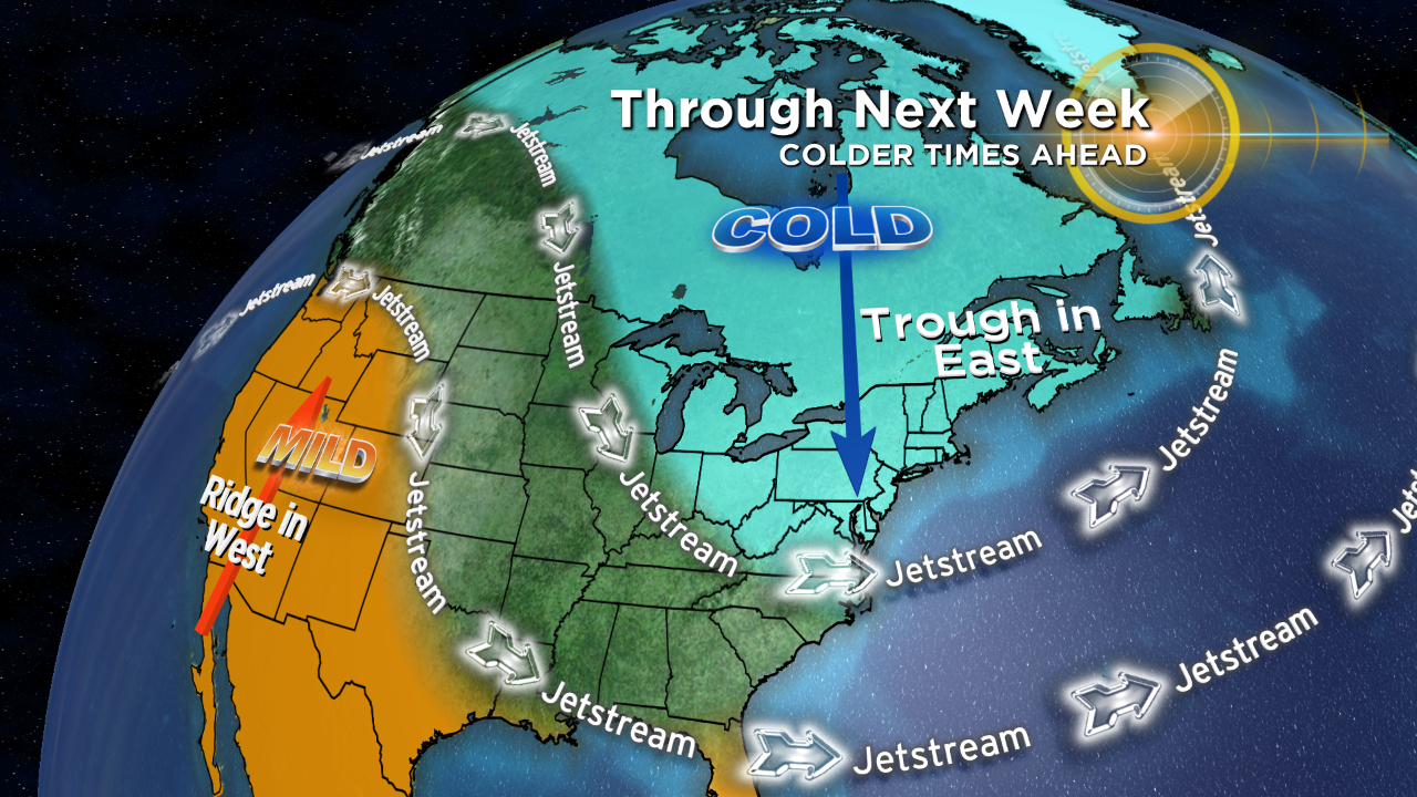
What's driving this change? A pattern flip in the jet stream. Most of January saw a trough in the west (responsible for big cold and tons of snow there) and a ridge in the east (well above average temperatures). Now, a ridge is building out west and a trough is settling in across the east. It looks like this type of pattern will be around for a while, so plan on colder air dominating through at least the first week of February. And along with that, higher chances for snowfall. If you feel like it always snows this time of year, you're right! Peak snow in Boston is late-January through the middle of February (so far as the averages go).
WHAT TO EXPECT
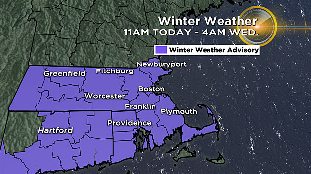
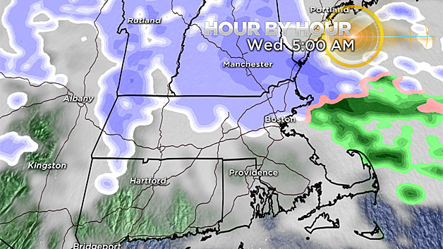
Tuesday brings back the triumphant return of the Clippah. I feel like we've barely mentioned Alberta Clippers in recent years. There's been an odd absence of these systems that swoop down from Alberta Province in Canada and race across the Great Lakes to New England. They're not often major storms, but can lay down healthy snow and kick up the wind. This particular one should blanket the entire area with plowable snow from Tuesday afternoon through Wednesday morning.
So far as timing goes, it should be getting slick by the time the Tuesday evening commute gets underway.

Snow should develop by mid-afternoon and begin to press eastward, covering much of the area by 6 p.m. Areas of moderate to heavy snow are possible, with the focus starting across areas around 15 miles north of the Massachusetts Turnpike down to southeastern Massachusetts.
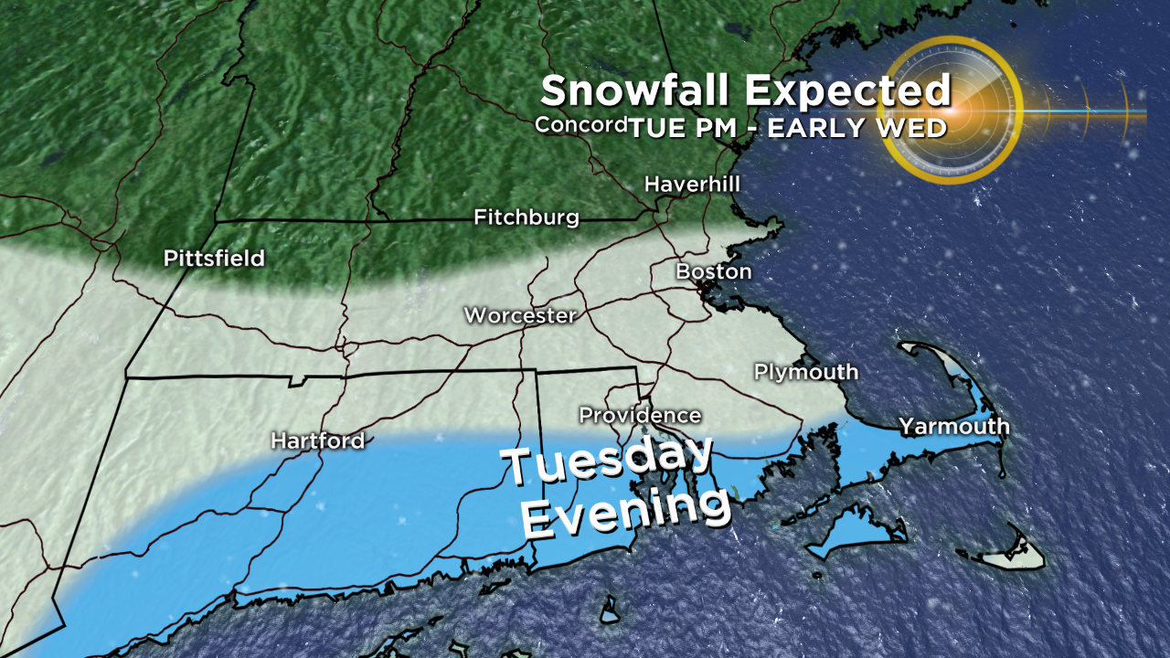
As the night wears on, snow should fill in across northern Massachusetts and New Hampshire, and that is expected to linger into Wednesday morning.
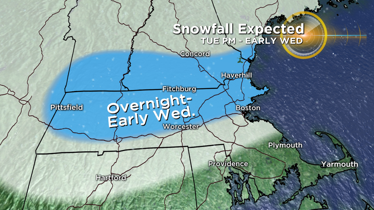
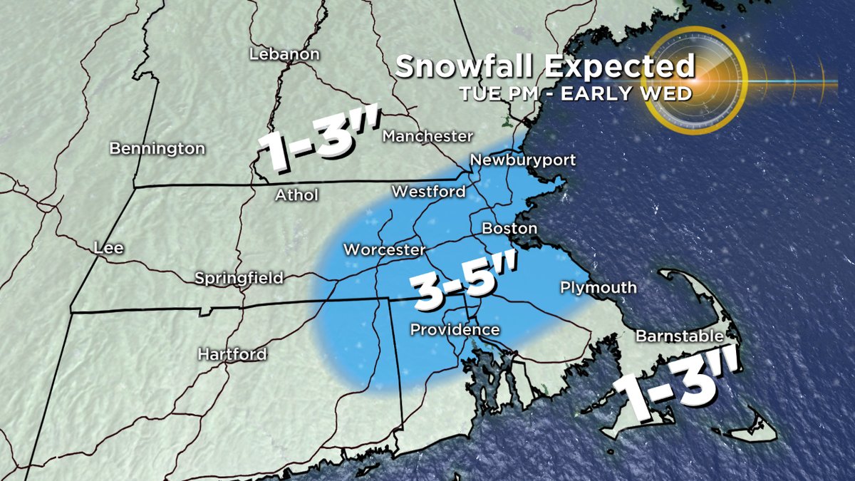
Although a widespread 1-to-3 inches looks very likely, there should be a zone of 3-to-5 inch totals. Nailing down this particular spot will be tricky, because it'll come down to where an inverted trough sets up overnight.
It may be a situation where we can't nail it down until sometime during the day Tuesday. Will it have a huge impact? Probably not. We're talking a couple extra inches of fluffy snow and most everyone will have a plowable snow anyway.
But the bottom line is that while most should fall in that 1-to-3 inch camp and isolated 3-to-5 inch totals are expected.
WHAT'S NEXT?
Event number 2 is during the day Wednesday.
While the initial low will be pulling away from the coast, there will still be instability and moisture left behind across New England. Scattered squalls should form, which can lay down another quick 1-to-2 inches of snow as they blow on through. Plus the usual squall elements of low visibility and strong wind gusts. So we'll have to keep a close eye on these as they push through Wednesday midday/afternoon.
The biggest hazard will be briefly dangerous travel.
Once these move out, it'll finally look like winter again with a blanket of snow on the ground. And this time, it may actually stick around a few days!
Colder air continues to filter in to end the week, with highs stuck in the upper 20's to mid 30's through the weekend. Great news for ski areas to pump out some new snow, plus much needed for our local plant life. The January thaw had some of it waking up, including lilac buds starting to pop! Never a good thing for these plants to wake from their slumber in the middle of winter. Colder air will help them go back to bed.
SUNDAY INTO MONDAY
If a few inches of new snow is just enough to wet your palette but not satiate your winter appetite, we're also watching a possible storm for late Sunday into Monday.
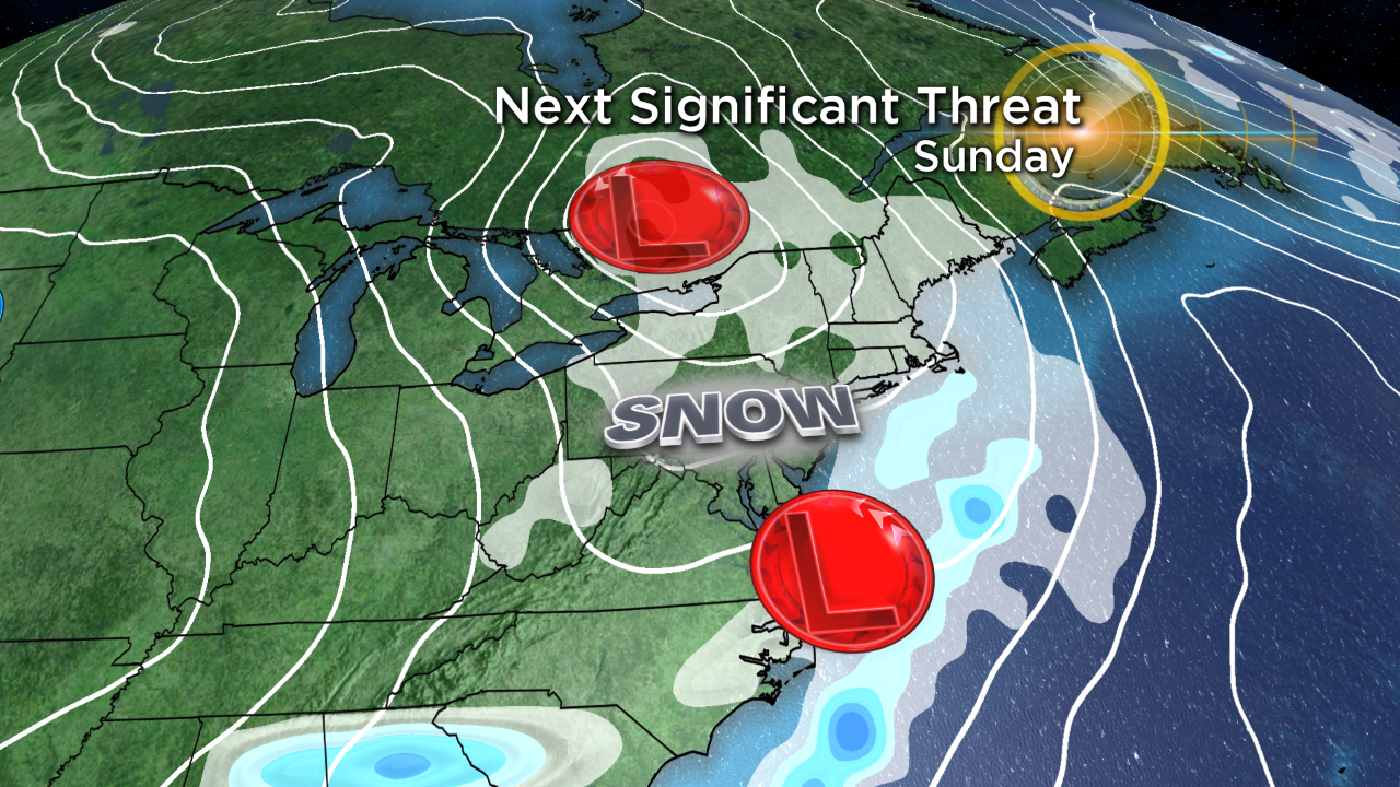
This one has been showing up in the model guidance for a week now. But while it's fairly easy to say 'the pattern looks right for a storm' many days in advance, the useful knowledge of 'how much' is never clear until a couple days out.
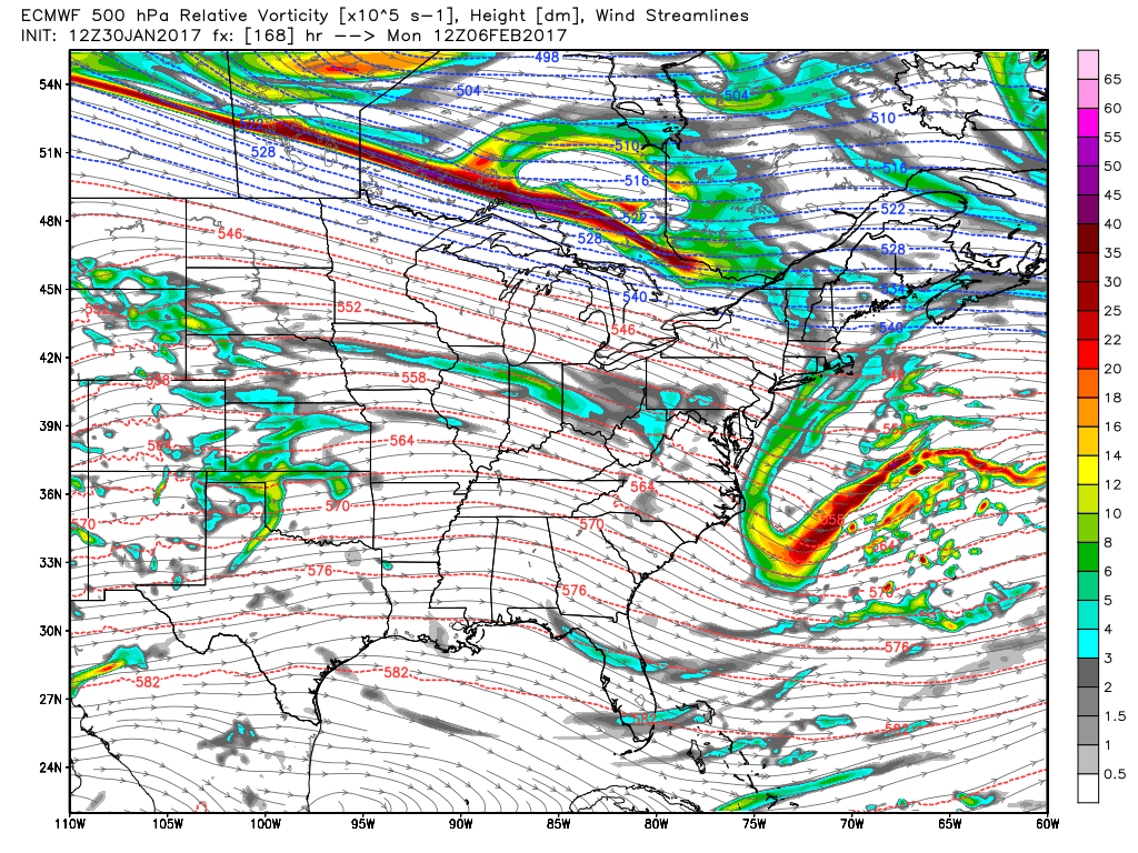
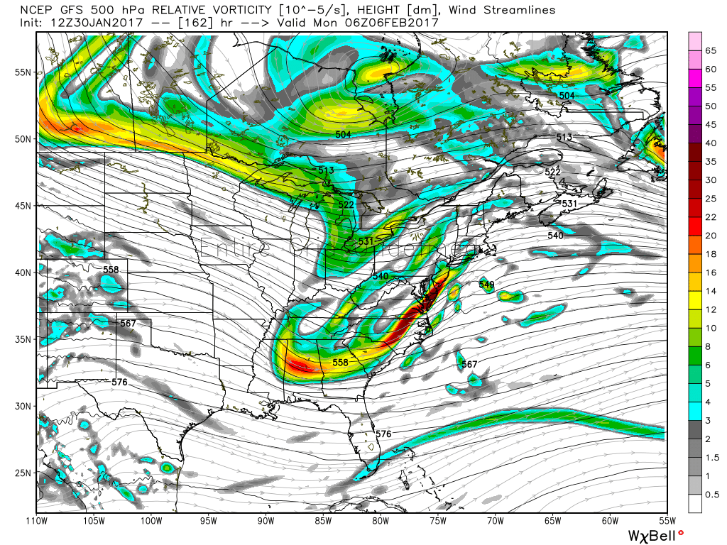
So what we can say at the moment is that it still looks good for a coastal storm to get going late this weekend.
The GFS has been most consistent with this one, taking a track that would give us significant snow. The Euro camp has a flatter flow and has generally not been favoring a large event. The difference here will come down to 'phasing' of the two streams (cross the streams, of course!). The flatter Euro pattern doesn't phase the northern stream energy with the southern stream, leading to a storm heading out to sea. The GFS brings these together with a stronger low climbing the coastline.
Basically, we'll just be keeping tabs on this one for the next few days.
It won't be locked in for a while yet, so no need to freak out about travel plans to go watch the Patriots. Plow operators are telling me they're already getting nervous about working during the big game - as am I as a meteorologist! We'll see how the timing and track work out.
Even if that one misses, there's another piece of energy that should swing our way later in the week with yet another snow chance. So while it's not the epic 'snow blitz' of a couple years ago, the pattern is much more favorable for snow over the next couple of weeks.
And if you really want to go long range, there are signs of a mid-month break to milder air before plunging back in to a colder and possibly snowier setup to end the month and start March. I think there's ample opportunity to get our snow totals up to typical levels before too long.