Two Storms To Coat Cape Cod In The Next Three Days
CAPE COD (CBS) -- Cape Cod, get ready. We are tracking not one, but two snow storms, which will be centered over Cape Cod in the next 3 days. For a region that is typically our least snowy, if you are a lover of flakes, Cape Cod and the Islands will be the place to be through the weekend.
The Cape won't be the only place to see snow, however. Will you be shoveling or plowing? Let's back up a bit and take you through both storms, region by region and inch by inch.
Storm #1
I hesitate to call this one a "storm." It is more like a wave or a disturbance. Storm #1 will be a very quick shot of snow and will remain confined to southeastern Massachusetts for the most part.
Timeline:
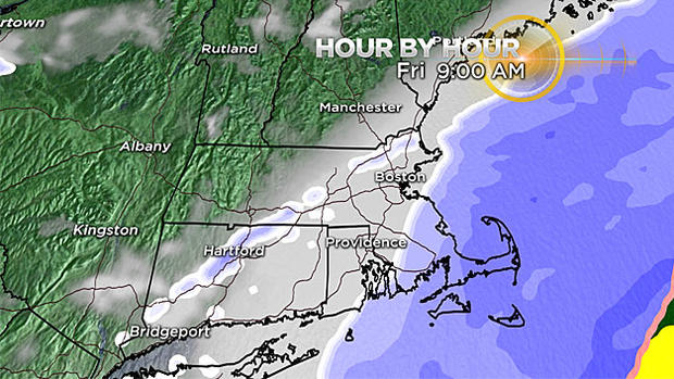
Some flurries and pockets of light snow will break out after 10 p.m. Thursday night across southern New England. The steady, accumulating snow will begin around 3 a.m. in southern Plymouth and Bristol Counties and across the Cape and Islands. Light to moderate snow will fall in this region for about 6 to 8 hours, tapering off to flurries by noontime.
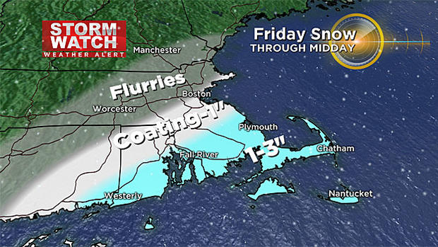
How Much:
1" to 3" - From Plymouth to Attleboro and areas south including the South Coast, all of Cape Cod and the Islands.
Coating to 1" - From Boston southward including all of Norfolk County and northern Bristol and Plymouth Counties
Flurries, scattered coatings - for areas north and west of Boston including Essex, Middlesex and Worcester Counties as well as extreme Southern New Hampshire
Storm #2
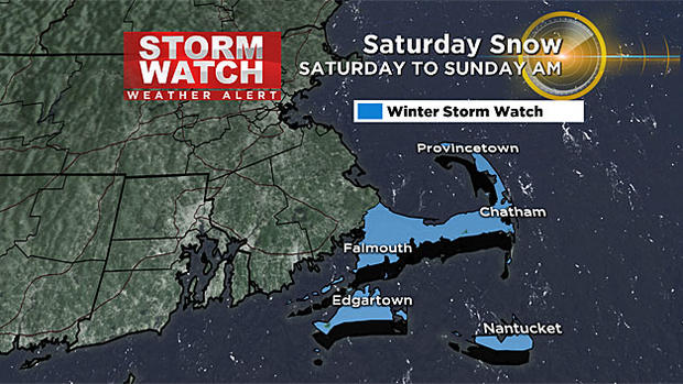
A much more significant storm than Storm #1, this one bears more watching. It will begin by dumping large amounts of snow in areas that truly aren't used to it. Six to 12" are currently forecast to fall across parts of Tennessee, North Carolina and southern Virginia. From there, it turns northward and here is where there is still some uncertainty. The most likely scenario would be for a track too far east to bring much snow to our area. Just a "grazing" for southeast MA with the majority of the snow falling over the fishes, out to sea. However, we cannot yet rule out a slightly more western track. Even a slight jog to the left could bring some very heavy snow bands onshore during the day on Saturday and make this a much bigger deal for southern New England. While this solution is less likely, it cannot yet be ruled out. The timeline and amounts below are using the most likely scenario, a farther east (out to sea) track.
Timeline:
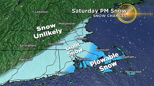
Light snow/flurries would break out around midday over southeastern Massachusetts. Steady light to moderate snow would likely fall from about 1 p.m. to 11 p.m. Saturday. Location looks very similar to the first storm, centered over southern Plymouth county, Cape Cod and the Islands.
How Much:
A tad too early for exact numbers given the uncertainty in final track, BUT…
Best chance of plowable snow (3" or greater perhaps) - From Plymouth to Attleboro and areas south including the South Coast, all of Cape Cod and the Islands.
Light snow, coatings or small accumulation – Eastern MA including; Middlesex, Essex, Suffolk and Norfolk counties.
Very little if any snow – Worcester County and areas north and west including Southern New Hampshire
Sadly, the ski areas will not get in on the fun from either event, but they have had a blockbuster start this year. Many northern ski areas in Vermont and Maine have already exceeded their total snow amount from all of last season!
Again, I would stress that you stay tuned to WBZ-TV and CBSBoston.com for updates. While there is unlikely to be much change to Friday's minor event, Saturday's storm is absolutely one to keep an eye on.