Major Snow For Northern New England, Rain For Eastern Mass.
BOSTON (CBS) - Rain, snow, wind - for a dry and relatively quiet 2016, we are going out with a weather bang. First and foremost let's hit some major headlines and dispel a few bad rumors.
This really is NOT a nor'easter, at least not for southern New England.
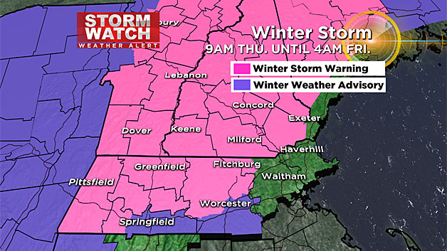
The most important part of a nor'easter is the northeast winds (hence the name). Winds in southern New England will be just about anything but northeasterly with this storm. For the majority of the event, winds will be out of the southeast (a very warm wind direction for a winter storm here). During the latter half of the storm the winds will turn westerly, that is when we expect the strongest wind and some damage to occur. Where will it be a nor'easter? Up in the mountains of New Hampshire and Maine.
There will NOT be much snow around Interstate 495 and certainly not much of any inside I-95.
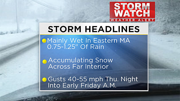
The vast majority of the precipitation will fall as rain in eastern Massachusetts. Certainly nothing plowable or shovelable during the day Thursday inside of 495. If any snow accumulates in eastern Mass. it would be after 7 p.m. as the storm deepens and passes our latitude in what we call a "backlash." The backside of storm systems are typically hard to predict and pinpoint how much snow, if any, will be able to accumulate.
Let's dig in to the nitty gritty and walk you through the storm piece-by-piece.
Thursday Afternoon: Noon - 5 p.m.
The storm begins as light snow for most of the area but temperatures quickly rise and the snow changes to rain in all of eastern Massachusetts. The rain/snow line will setup shop west of 495 and well north of the Massachusetts Turnpike. So in order to be clearly in the "snow zone" you would need to be as far west as Gardner, Athol, Orange or the Berkshires in Massachusetts. In New Hampshire it will be all snow in southwestern areas like Keene and Jaffrey and most spots north of Manchester.
The rain and snow will pick up in intensity as the afternoon wears on and if you are an evening commuter today, you will face areas of heavy rain in eastern Massachusetts and a heavy, wet snow in those areas outlined above.
Thursday Evening: 5 - 10 p.m.
During this time frame, the center of the storm will pass over southeast Massachusetts. There will be some very heavy elements of rain and snow, making travel difficult.
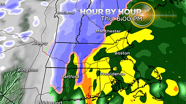
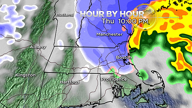
The rain/snow line will begin to collapse eastward after 7 p.m. turning the rain to a heavy, wet snow in northern Massachusetts (including most of Middlesex and Essex counties). By 10 p.m. it will be snowing in all of northern Massachusetts and southern New Hampshire. A couple inches of wet sloppy slush will accumulate in these areas.
Thursday Night: 10 p.m. - 6 a.m.
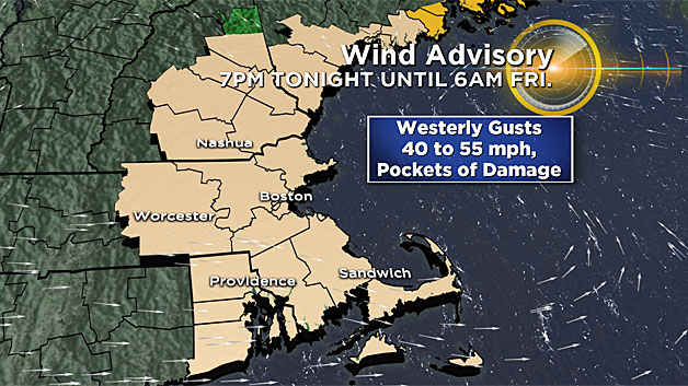
The rain and snow will taper off and end by midnight. The winds will shift to the west and steadily increase overnight, gusting 40-to-55 mph in most of eastern Massachusetts.
This will cause some minor wind damage (limbs down, scattered outages). More significant damage may occur in areas that received higher snow amounts (northern Worcester County, southwest NH) due the weight of the heavy snow on limbs combined with the gusty winds.
Friday Morning: After 6 a.m.
The winds will decrease below advisory level Friday morning, but remain somewhat gusty for most of the day (15-25 mph+).
Other than that, Friday will be quiet, a mix of sun and clouds with highs above the freezing mark, helping to melt some of the minor snow accumulation that occurred to the north of Boston.
So how much?
This will be a beneficial rainfall event for eastern areas, keeping in mind we are still very much in a severe drought. On average, expect about in inch of rain to fall in and around Boston and near the coastline.
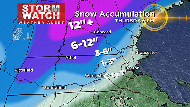
As for the snow:
Coating-to-one inch:
On the backside of the storm (late tonight) from 128 to 495 north and west of Boston.
One-to-3 inches:
Again on the tail end of the storm tonight around the 495 belt from Marlboro to Westford to Lawrence. This also includes most of southeastern New Hampshire from Nashua eastward to Portsmouth.
Three-to-6 inches:
Heavy, wet snow in far northwestern Middlesex County and a good portion of Worcester County north of the Pike. This also includes Manchester, NH.
Six-to-12 inches:
This snow will be in extreme northern Worcester County, just west of Fitchburg and points west like Athol, Orange and Greenfield, and all of southwestern New Hampshire including Keene and Jaffrey.
One foot or more:
Expect this much in central and northern New Hampshire including many of the northern ski areas! Also included would be the hills and ski areas of Maine, northwest of the major cities.
The bottom line - this not a major snow event for southern New England, but a jackpot for northern ski areas!
And if you are already looking ahead to this weekend, other than a few light rain and snow showers Saturday night, there are no major weather concerns as we ring in the new year.
Stay safe, Happy New Year!
Follow Terry on Twitter @TerryWBZ