Weather Alert: Thursday Storm Could Bring 6+ Inches Of Snow To New England
BOSTON (CBS) -- From the warmth and wind this morning to significant snowfall possible by Thursday. It's the rollercoaster ride of New England weather that we all love (or hate, LOL) and try to keep up with. So let's dig a little deeper into what the setup is like for this storm on Thursday.
A big dip in the jetstream (trough) is going to dive into the Ohio Valley & Great Lakes Thursday morning. This energetic disturbance is going to combine with southern stream moisture with ties all the way to the Gulf of Mexico. The storm center itself will develop and strengthen as it moves towards southern New England, but especially in the Gulf of Maine as the storm rapidly intensifies Thursday night into Friday morning. We're still about 48 hours out from the start of this event, so it goes without saying that there's still some uncertainty in the exact track, timing and expected snowfall totals. Here's what we know right now…
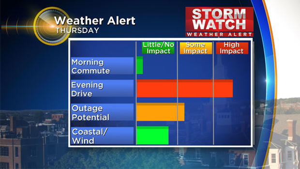
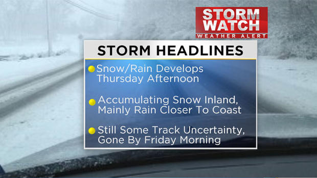
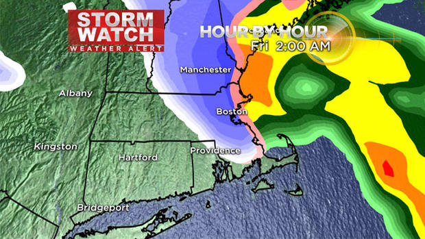
Timing: Your commute to work on Thursday morning will be just fine. Areas of snow and rain don't arrive until Thursday afternoon. I would be proactive and budget or plan on spending some extra time on the road for your ride home from work on Thursday.
The snow and rain will fall at a pretty good clip Thursday evening, with a period of moderate to heavy snow and rain after the evening commute into the first part of the overnight.
It's all out of here by Friday pre-dawn. So this is a fairly quick hitting storm.
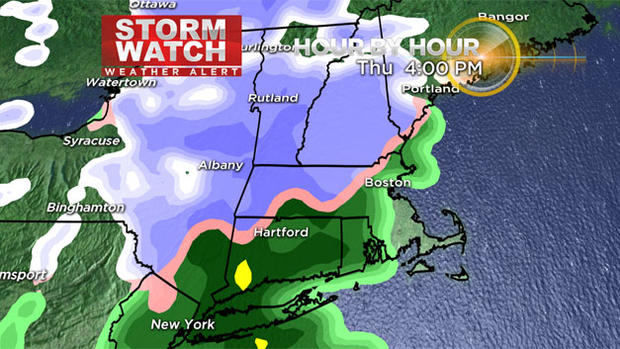
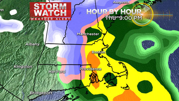
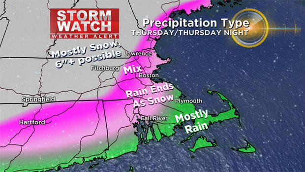
Precipitation Type: In most of eastern MA, the precip will start as rain, with the rain/snow line setting up somewhere around the 495 belt Thursday afternoon. The rain may push even farther northwest, into central MA & southern NH briefly during the evening. Late Thursday evening and night, colder air is going to whip around the backside of the storm causing the rain to change briefly over to snow even at the coastline as the storm departs.
Amounts: There will likely be a very sharp gradient in snowfall amounts from the coast to communities through the interior. Little if any accumulation is expected in far eastern MA, although the wrap around moisture may drop a coating to 1" in spots. In between 128 & 495, a few inches are possible…and the highest totals (potentially 6 or more inches) are likely outside of 495, but especially from northern Worcester County into western NH & western MA.
Wind, Coastal & Outage Concerns: The strongest wind with this storm will occur as the storm departs Thursday night. Some gusts may top out between 40-50 mph and may result in isolated pockets of damage (similar to this morning). Some outages will also be possible where 6"+ falls due to the heavy, wet nature of the snow through the far interior. Since the storm is moving pretty fast, I'm not overly concerned with coastal flooding or beach erosion, although seas will build 6-10 feet on our outer waters, so the marine community should be aware of that and areas of reduced visibility.
We'll keep you posted on our thoughts every step of the way, on-air and online.
-Danielle


