Active Week Of Weather To Close Out 2016
BOSTON (CBS) – I hope everyone had a very Merry Christmas and is enjoying the holiday season!
Although our weather is fairly quiet this morning, the overall pattern is going to be pretty active for the week ahead. We've got several things to keep a close eye on, two of which will occur in the next 24 hours.
Let's start with later on today.
The winter storm that has been wreaking havoc on the northern Plains & Midwest is slowly shifting east. What does that mean for us here in New England?
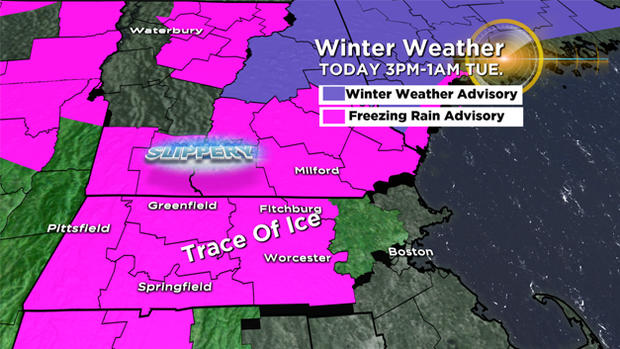
Clouds will increase and some very light precipitation will develop by early this evening. Temperatures will be slow to rise today, which means a few areas north and west of Boston, mainly in central/western Massachusetts could still be right around 32 degrees when the precipitation arrives.
Some pockets of light freezing rain are likely in these areas, although they will be isolated. All it takes is a trace of freezing rain to slicken the roads though – so keep a close eye on that car thermometer & take it slow if you're traveling this evening. I'm expecting a more significant impact from central Vermont to central NH, where as much as a tenth of an inch of ice could accumulate in spots.
Overnight, the temperatures will rise – so precipitation will be in the form of rain as it comes on through. Expect showers and downpours for your morning ride tomorrow, ending from northwest to southeast from mid to late morning. Clearing will come in pretty quickly after that.
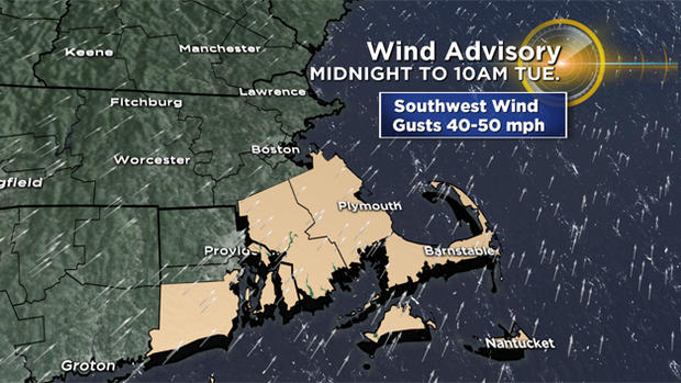
On to the wind. The southwest wind is going to ramp up tonight, and gusts 30-40 mph are likely for most of us.
Stronger gusts on the order of 40-50 MPH are possible in southeast Massachusetts, which may result in some pockets of damage and outages until late tomorrow morning. The remainder of the day tomorrow will be windy, but gusts will be below damaging thresholds.
Wondering about the rest of the week? Wednesday will be a quiet day overall, but Thursday brings our next chance of rain and snow.
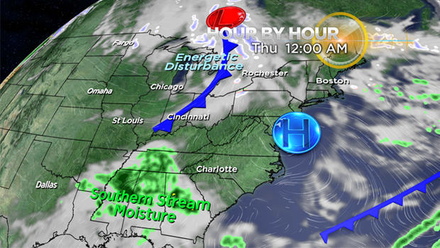
Right now, there are signs that an energetic disturbance out of the Great Lakes will try and combine with some southern stream moisture to create a strengthening storm center over New England. There's still some uncertainty in the track and timing of this system, so we'll have to monitor this closely over the next couple of days.
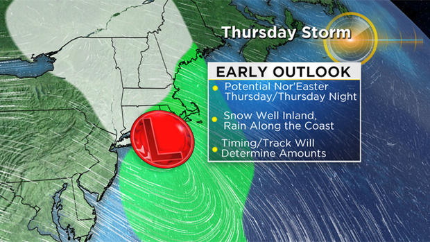
It looks like the best chance of accumulating snow would be through the far interior, with rain elsewhere.
Still figuring out your New Year's plans? The weather should cooperate for the most part this weekend, although it will be colder. As the ball drops at midnight, temperatures will be in the teens and 20s with the chance of a few flurries.
Be ready to bundle up! New Year's Day may feature some light snow or rain, especially during the first part of the day.
Stay tuned for updates all week long on air and online.