Matthew Expected To Be Strongest Hurricane To Hit U.S. In 11 Years
BOSTON (CBS) - Hurricane Matthew is barreling through the Bahamas right now, with the core of the strongest wind coming over the west side of Nassau.
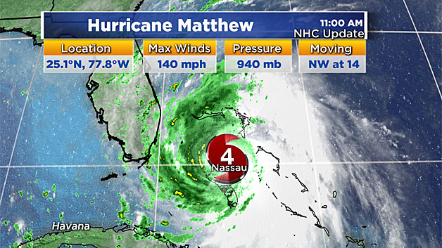
The eye is threading the needle between the capital city and Andros Island and gusts as high as 85 mph have already been reported there. The outer rain bands of Matthew are now pushing into parts of southeast Florida, and conditions there will deteriorate quickly from here on out.
Check: Hurricane Matthew Tracking Maps
Matthew will likely end up being the strongest hurricane to hit the United States in 11 years. Meanwhile, the U.S. has not had a major hurricane (Category 3 or stronger) make landfall in 4,000 days – the longest stretch on record by far.
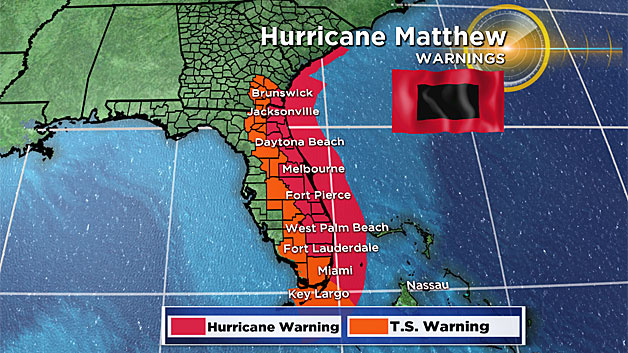
Hurricane warnings and tropical storm warnings have now been expanded to include parts of southeast Georgia.
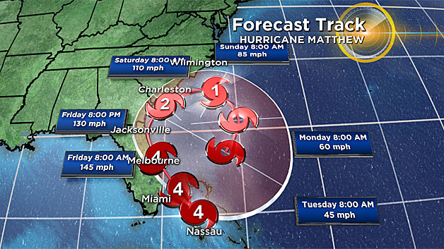
Matthew has re-strengthened to a Category 4 storm with 140 mile per hour sustained winds. Extreme damage will occur in many cities and towns along the entire east coast of Florida.
Could landfall occur somewhere along the coast of Florida? Absolutely.
Anywhere from West Palm Beach northward to Jacksonville will likely bear the brunt of this storm, although the scope of its damage will extend much further.
RAINFALL
A widespread 4-to-8 inches of rain will fall in parts of central Florida, southeast Georgia, eastern South Carolina and extreme southern North Carolina. Isolated totals of a foot are certainly possible.
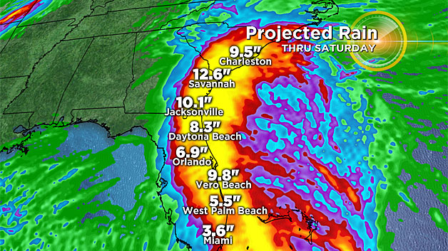
Flash flooding will result. Isolated, brief tornadoes may touch down as well.
STORM SURGE AND SURF
Storm surge will cause water levels to rise by as much as 3-to-5 feet in the coastal communities mentioned above. Life threatening rip currents and swells as high as 30 feet offshore will create pounding surf and significant beach erosion as the destructive waves crash ashore.
WIND
Hurricane force wind gusts extend 40 miles outside of the storm center, with tropical storm force wind gusts extending 160 miles from the eye of the storm.
Widespread wind damage will occur as these ferocious winds shift onshore in Florida Thursday evening, continuing through Friday in eastern (and parts of central) Florida, then impact southeast Georgia from Friday evening into Saturday afternoon.
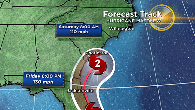
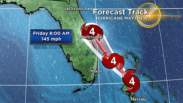
By Saturday night, Matthew should be several hundred miles off the coast of South Carolina as a Category 1 storm, and will continue to weaken as it moves east and then back south through the upcoming holiday weekend.
IMPACT IN NEW ENGLAND
So for us here in New England, this has been a fortunate turn of events.
It goes without saying that we could certainly use a tropical dose of rain to help alleviate our drought, but many are thankful that our holiday weekend forecast looks good.

An approaching cold front on Saturday may bring a few late day showers and usher in cooler air for Sunday and Columbus Day.
Stick with WBZ-TV, WBZ NewsRadio 1030 and CBSBoston.com for frequent updates.


