Hurricane Matthew Heading To Popular Vacation Spots
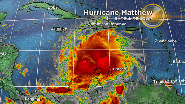
BOSTON (CBS) -- Hurricane Matthew is currently a dangerous and strong category 4. Friday night it become a category 5. This storm has been impressive to watch as it is just north of South America. However, things will turn more serious as it heads towards many popular vacation destinations.
Some facts (in recorded weather history):
Matthew is the 7th hurricane in the Atlantic to strengthen at least 80 mph in 24 hours or less.
Matthew is the southernmost category 5 in the Atlantic and is the closest ever to South America.
Last category 5 hurricane in the Atlantic was Felix, in September of 2007.
The ACE (Accumulated Cyclone Energy) is now 66. Which has met the NOAA definition of a "average hurricane season" for 2016.
Only 5 category 5 hurricanes have been recorded in October in the Atlantic. Wilma (2005), Mitch (1998), Hattie (1961), Cuba (1924), and now Matthew (2016).
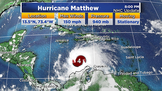
The latest update from the National Hurricane Center shows max winds of 150 mph and is now stationary. The storm will start to move north.
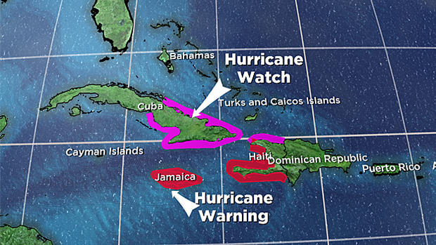
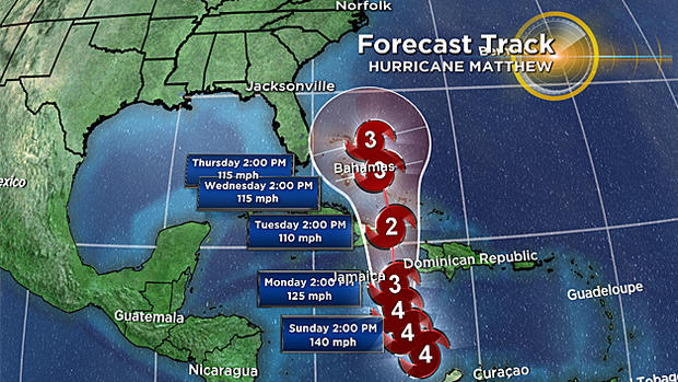
Jamaica & Haiti are under a hurricane warning. The eastern half of Cuba & northern Haiti are under a hurricane watch. The wind and rain will be devastating as the storm moves north between Jamaica and Haiti, but the storm surge is what usually causes the most injuries/deaths.
Life-threatening flash flood and mudslides are expected over southern Haiti. Expecting 15-25 inches of rain there with isolated areas getting 40 inches of rain. 10-20 inches of rain over eastern Jamaica, Dominican Republic and eastern Cuba.
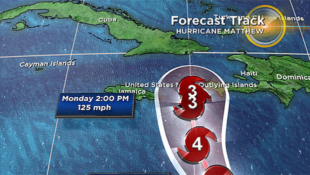
Sunday night into Monday the hurricane will pass between Jamaica and Haiti as a category 3 (125mph estimated winds). It continues north, to eastern Cuba Tuesday morning, with the friction of the land bringing it to a category 2. However, as Matthew moves over the Bahamas we may see intensification back to a category 3 Wednesday afternoon. Beyond Thursday, it's anyone's guess. Models have the storm heading along the east coast, to the northeast. But there are so many questions on how close to the coast it will get.
We are watching hurricane Matthew and the forecast very closely and will certainly update you on WBZ, MyTV38, on cbsboston.com and through social media as much as we can.
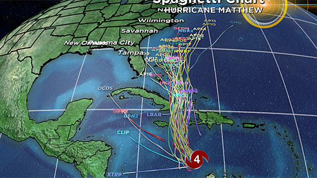
Please don't put too much weight onto any one particular model solution at this time, especially when we are talking 7 to 10 days away from now.
Here is the updated spaghetti chart on all the models and where they think the storm is headed. As we go further in time, notice the few models that even go out that far are all in disagreement.
In our immediate forecast this week, we kick out this gloomy trend of rain mid-week as a cutoff low moves out to sea.
Sunday, drizzle, spotty showers, some fog, temps around 60 & breezy.
Monday, a lingering shower, patchy drizzle, mostly cloudy and 66.
Tuesday, coastal drizzle, partly sunny inland. Highs in the lower 60s.
Finally some sun Wednesday and Thursday with highs in the mid to upper 60s.