Hurricane Hermine On Approach This Weekend
Find Eric Fisher on Twitter and Facebook
Believe it or not, we've been talking about/tracking this same tropical system for nearly three full weeks now. What took a long time to slowly organize quickly exploded in the Gulf on Thursday as Hermine become a potent hurricane before landfall. Amazing to think it had been nearly 11 years since Florida had a hurricane make landfall! When Wilma came ashore in October of 2005, there were no iPhones, no Twitter, and you needed a valid college email to sign up for Facebook. I'm sure no one was complaining in the sunshine state, but unfortunately the destructive power of the tropics came knocking again.
Now the attention turns to this weekend and the storm's path of the East Coast. In an interesting (and good) twist, the National Hurricane Center announced that they will continue warnings and advisories, even after Hermine becomes post-tropical. This is an important lesson from Hurricane Sandy in 2012. When Sandy was approaching the Jersey Shore, it was undergoing extratropical transition (basically, turning into a nor'easter and losing its tropical characteristics). This is mainly just weather semantics, but it made a difference. The NHC dropped Hurricane Warnings, and many thought the threat was diminishing when in fact it was increasing. So to avoid confusion, NHC will stay in control as Hermine comes up the coast and likely loses its tropical structure. In an interesting twist, New Jersey may be the state to benefit most from this, since it may take a strong hit from the storm.
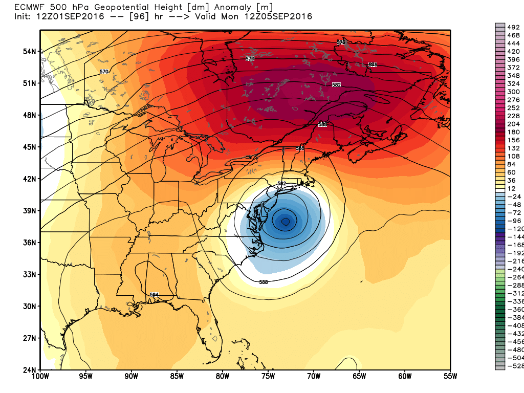
The 'banana ridge' sitting over the top of Hermine will stop the storm in its tracks, and then trap it offshore for days. Source: Weatherbell
So let's get to the forecast. Not much change from yesterday, thankfully. Guidance has locked in on a solution that takes Hermine up the coast and then stalls the storm east of New Jersey. A strong 'banana ridge' will build over the storm, stopping its progress and then forcing it to stall out for days. After reaching peak (East Coast) power Saturday into Sunday, the storm will slowly start to blow itself out Monday through Wednesday, but it will never wander far from our coastline. Lost in a no man's land with no steering currents to direct it out to sea. Below is a look at our local forecast through the holiday weekend.
Friday: Let's keep this short...a great day! Go outside and enjoy. 70s, dry air, a northerly breeze, and bright skies.
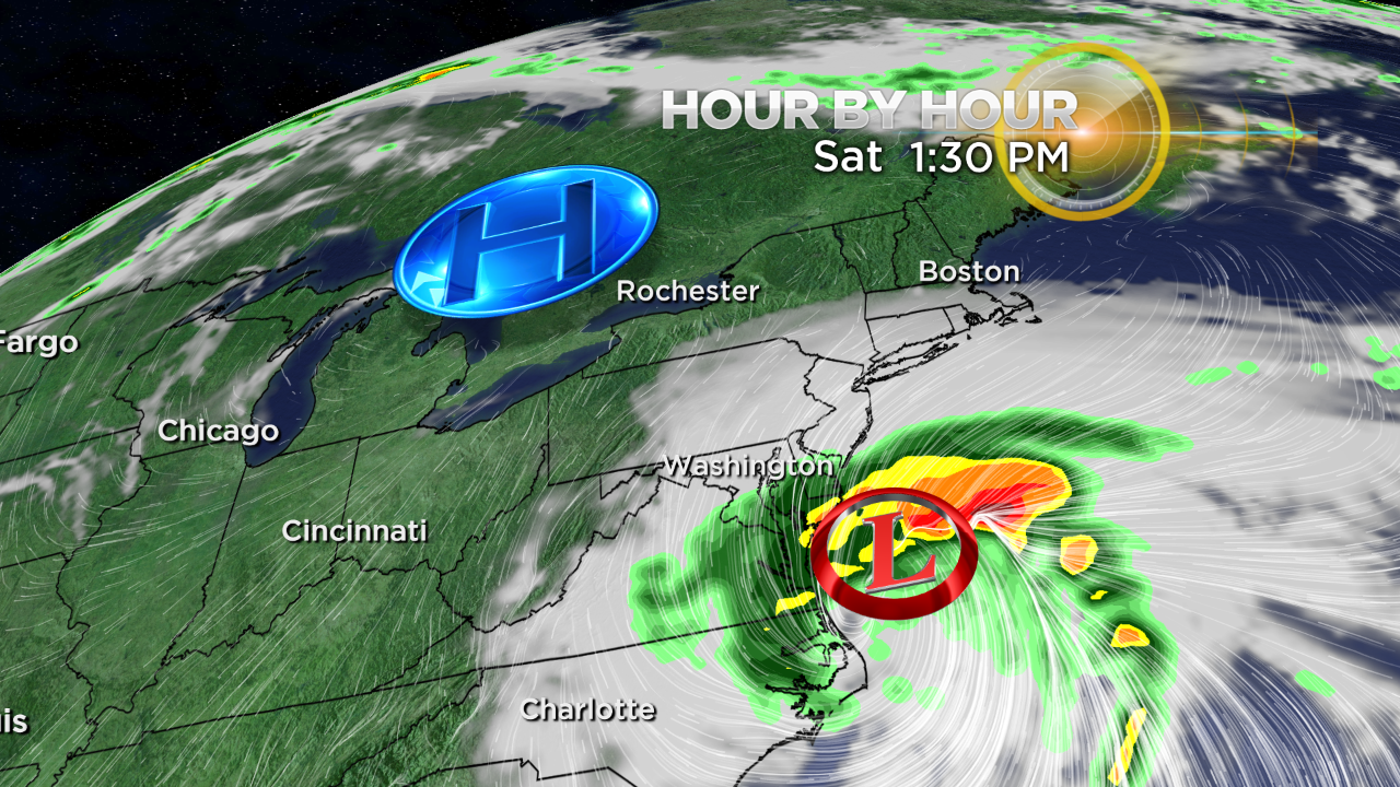
Saturday: Looks like a safe day to enjoy the outdoors. Hermine will be off the Mid-Atlantic coast, but far enough away to keep us away from any significant impacts. We'll see a steady increase in cirrus clouds overhead from south to north, and the breeze will begin to increase from the east - particularly felt at the coastline. We may start to get some 15-30mph gusts in the afternoon, and seas will already be choppy. Other than that, it's 70s and dry air. Shouldn't be any major issues for the fireworks over Boston Harbor Saturday evening either. For anyone in northern New England, it should be a great day. No concerns for hiking or camping, and you'll enjoy some sunshine to boot.
Sunday: This is the trickiest day of our forecast. There are still some timing issues on when rain may start to move in. We're definitely looking at thicker cloud cover, although some sunshine may survive a good part of the day in Vermont/New Hampshire/Maine and far northern Massachusetts. I'd expect a pretty thick cloud deck south of the Pike all day. Winds will continue to increase as high pressure to the north and Hermine to the south pump in east/northeast winds, which will start to gust 25-40mph by days end. The cloud cover will keep us on the cool side with highs within a few degrees of 70.
In terms of rain, the highest odds of downpours swinging in will be across Rhode Island, Connecticut, and SE Mass. By late in the day, those showers/downpours may be able to punch north of Boston. But there's going to be a big infusion of dry air from that high to the north, which may be able to hold rainfall there at bay until Sunday night.
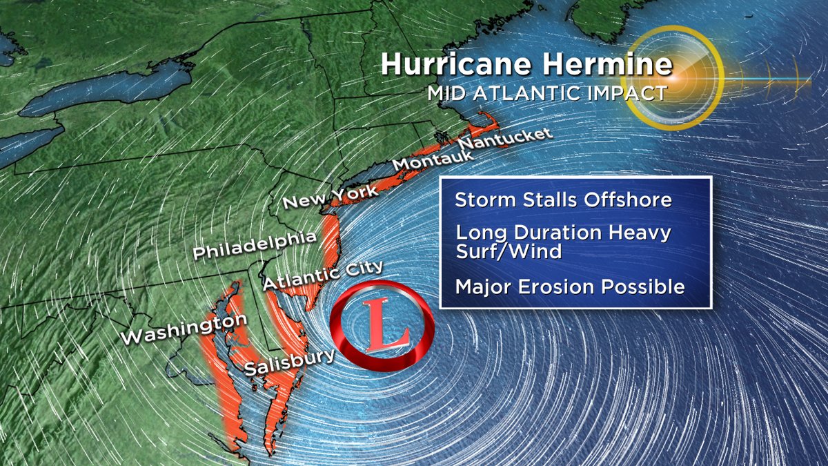
Surf will be running high by Sunday and the rip current risk will be elevated as well. Fortunately for us, astronomical tides are not especially high. No coastal flooding is expected on Sunday.
Meanwhile, there will be a nasty situation unfolding to our south. A slow-moving but powerful storm is a good recipe for major erosion. It looks like the worst region of erosion will be from Long Island down to coastal Maryland, centered around the Jersey Shore. This system has the potential to really chew up the shoreline since it will be around for several days. Gusts toward the Jersey Shore should top 60mph on Sunday, whipping up the surf. Locally, we're expecting minor beach erosion...but it's a situation we'll have to monitor in case the storm ends up a touch farther north.
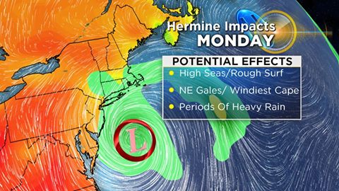
Labor Day Monday: The highest impact from Hermine (which may no longer be tropical at this point...more a nor'easter type storm) is expected to come Monday. As the center drifts a little farther north toward our coast, the rain bands and wind are expected to come along with it. Periods of rain, heavy at times, should rotate through the area. The highest concentration of heavy rainfall should be south of the Pike, particularly the Cape & Islands. These areas have the potential of 2-4" of rain, provided the storm comes far enough north. Rain totals will be lower the farther north you go. Currently, it looks like areas along or north of Route 2 will end up with less than 0.5" of rain unless there's a substantial jog north. We'll have to keep our fingers crossed that if it's going to rain on Labor Day, it's at least worth our while and dents the drought! Some of the rain showers may make it as far north as New Hampshire and Maine on Monday after being held away on Sunday.
Surf will really be rocking by this time, and we could end up with pockets of minor coastal flooding during Monday's high tide cycles. Winds will also be on the upswing. Northeast gusts 30-45mph are likely, and if the storm comes just a few miles farther north we may be able to see some 45-55mph gusts on the Cape/Islands. Considering the wind potential, there may also be ferry disruption on Labor Day.
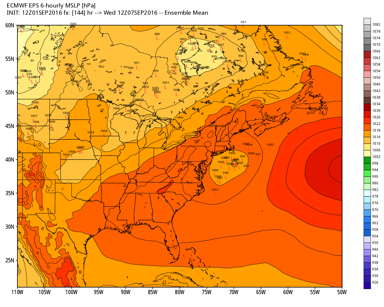
The Euro EPS still has the system just south of Nantucket on Wednesday of next week. Source: Weatherbell
Rest of the Week: Hermine's remnants go nomadic next week, trapped with nowhere to go. There's a chance the low, weakening each day, will spin just offshore all the way through Thursday. If it doesn't get far enough away from us, this could keep showers and cool weather in the forecast for Tuesday and Wednesday. If it can get a little farther out to sea, we'll jump into the 80s again by mid-week. There's a lot of uncertainty still for this part of the forecast so stay tuned...although we have to root for the unsettled and gray setup to help our landscape recover from a record dry summer!