Tracking Hermine - A Close Call This Weekend
Find Eric Fisher on Twitter and Facebook

If anything, this is good practice for snow season. Much like a fickle developing nor'easter, this relatively weak tropical system has been a thorn in our side. Can you believe we've been watching it for over 2 weeks now? For a long time Hermine refused to form...slowly ambling along through the tropics. Once into the bathtub waters of the Gulf and with lower wind shear to help out, intensification began. Now that we know Florida and the SE Coast is in for a large dose of flooding rain, storm surge, tornadoes, and wind...the forecast attention starts to move north. What impact will it bring several days from now?
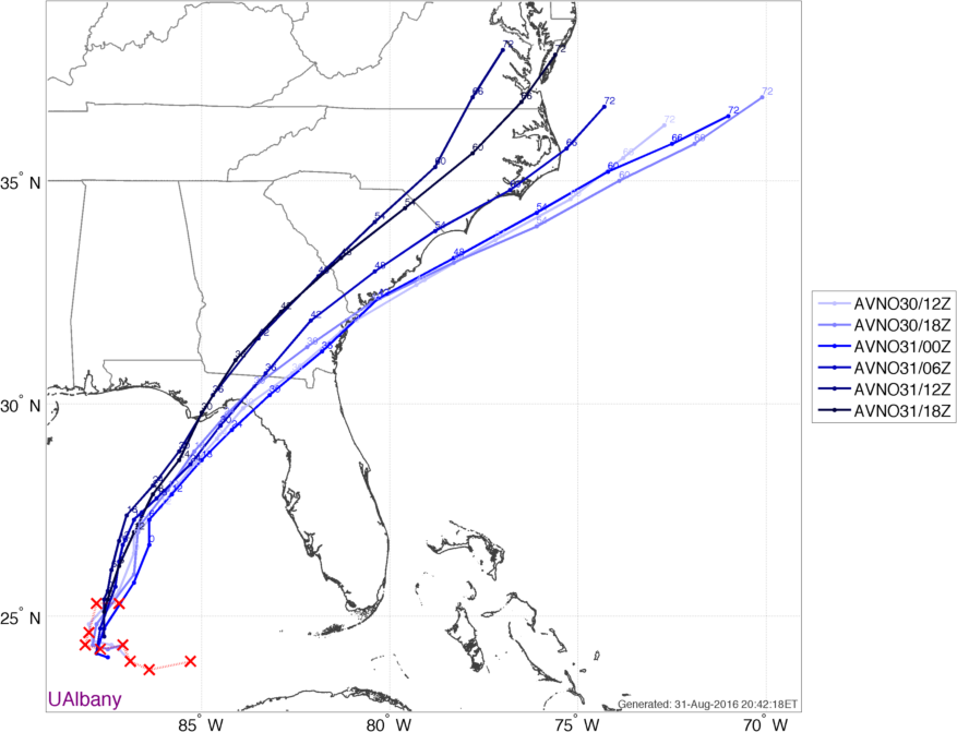
A look at the past several GFS runs (dates and times on the side). Each one progressively farther west over time. Source: UAlbany
The biggest trend on Wednesday was a shift to the west. All guidance followed this trend, taking the storm into Florida late Thursday night and then up the eastern seaboard to start the weekend. Now heavy rainfall and strong winds are likely into Georgia, the Carolinas, and perhaps into the Mid-Atlantic as well. Areas from Maryland up to NYC definitely need to start paying closer attention. And then - full stop. That's where our biggest forecast questions come into play.
A large ridge of high pressure is expected to build over the top of New England this weekend and stretch into the North Atlantic, essentially closing the escape hatch for Hermine. That ridge will also halt its northward progress by Sunday. So here's the rub - will it stall out far enough south to keep rain away from us in southern New England, or just north enough to bring us much-needed drought relief? Right now, it looks like the stall will occur south of Long Island, which would keep rain totals tepid here. The highest odds of rain are along the South Coast, while areas to the north stand a much lower risk of washed out BBQs. In fact, I wouldn't expect any rain in northern New England at this point. So any weekend plans in New Hampshire, Vermont, or Maine are looking safe and pleasant. Especially if you're heading toward the White Mountains for some hiking or camping. High pressure should protect the region from any significant impact.
Let's play this out in 2 scenarios...from 'worst case' to 'best case'
WORST CASE:
Hermine tracks right along the coast and stays over open water. This allows the storm to retain some tropical characteristics and strength as it moves north. It gets right up to the South Coast and soaks the region with heavy rain and gusty winds that could be just strong enough to cause some scattered damage. This is keeping in mind that trees are very weak and easily damaged right now. Heavy surf and onshore winds could produce some pockets of coastal flooding and erosion. Essentially, it would be a mid-grade nor'easter for us. Not widespread damage, but a nasty little weekend storm that would be here for Sunday and Monday (possibly into Tuesday too). Tides are high but not near peak levels (more than a foot below the highest tide of the month) so that should help us out a bit.
BEST CASE:
The storm tracks well west, and stays inland west of the I-95 corridor. It loses tropical characteristics and becomes extratropical (again, more like a nor'easter). It stalls out south of Long Island and the rain shield only tickles the South Coast or stays out to our south/east altogether. Clouds may increase and temps would be on the cool side, but most plans could go on as scheduled. The only main impact would be rough surf & rip currents for anyone at the beach from Saturday onward. There's also a bad side to the 'best case' - we need that rain! Even if the timing stinks, it would really help us out.
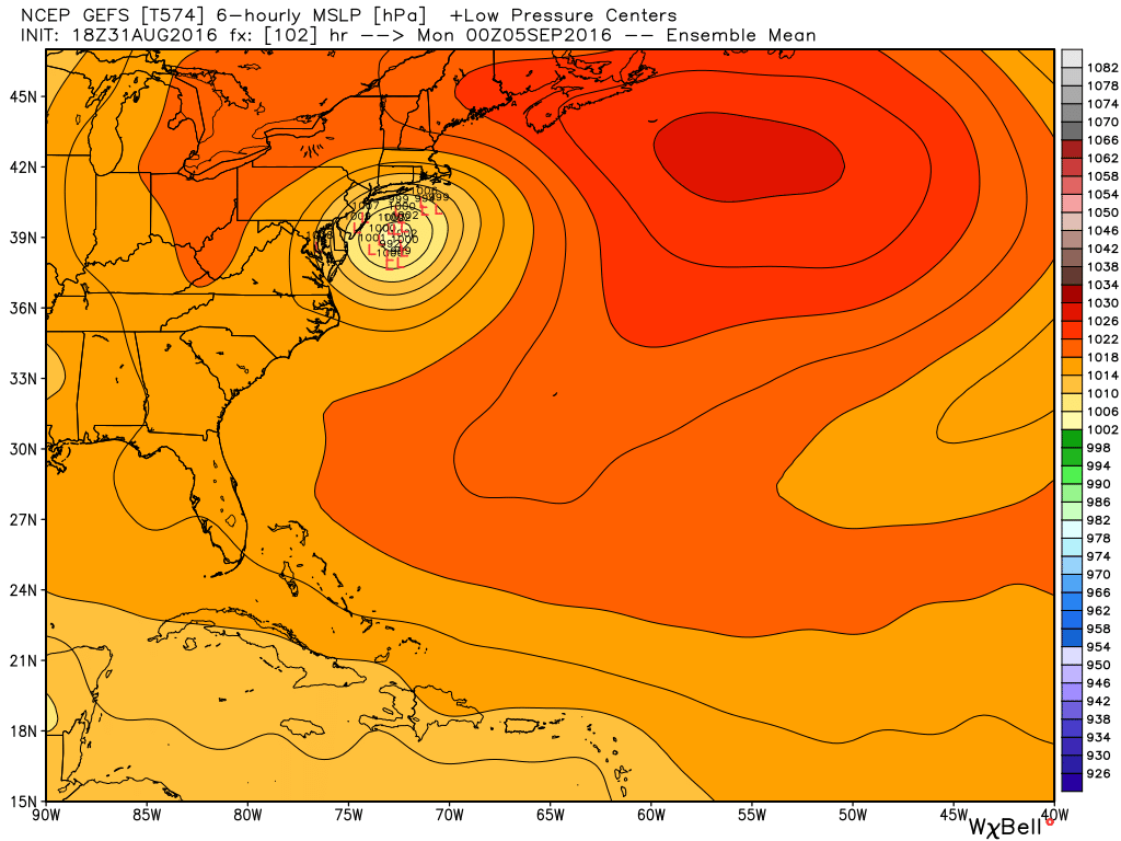
GEFS is clustering just off to our south...enough to bring some rain but overall the highest impact would be to our southwest. Source: Weatherbell
Both of these scenarios are still on the table for us, considering we're still 4-5 days out. As a takeaway, I wouldn't change any weekend plans yet. Give it at least another day, if not two. Very subtle interactions with the way the ridge forms and how the trough swinging in to grab the storm develops could make for significant track changes. And since we're on the fringe of this thing, 150 miles is the difference between bright skies and dry weather - or pouring rain and gusty winds. Plans in northern New England look good, and you should be on more alert for possible changes the farther south you go. 24-36 hours from now we'll hopefully have a better lock on the exact track and how far north rain will make it. And though you'll probably hear names like Irene or Sandy thrown around on the internet here and there, simply because they're in recent memory, this is neither. It will not be nearly as powerful as either of those systems, and is taking a completely different track. So put them out of sight, out of mind. Each storm has it's own flavor and it's still yet to be determined whether this one will be vanilla for us or not.