Boston To Crush Warmest August On Record
Brace yourselves, the air conditioning bill is coming.
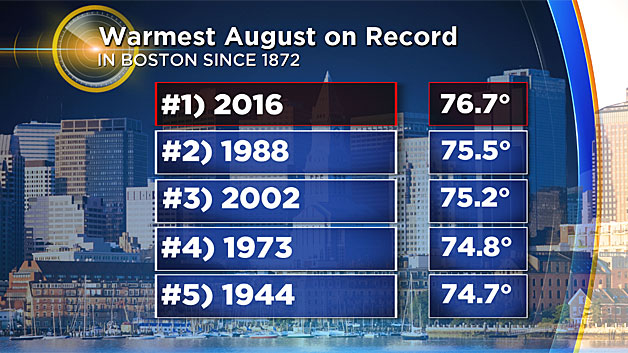
A cool start to summer most certainly did not last, with the furnace kicking on during mid-July. Since then, it's been full steam(y) ahead with meager cold fronts delivering little but wind shifts. The continuing drought story is the higher-impact event, but this month's heat has been impressive. Since weather records started being kept in 1872, this will be the hottest August the city of Boston has seen. And it won't even be close.
It will come down to the last 2 days of the month in Providence, Worcester, and Hartford - which will all finish 2nd if they don't nab the top spot. It'll be a photo finish.
Being ahead of the current record holder, 1988, by a little more than a degree probably doesn't sound like much. But to put it into perspective, 1 degree Fahrenheit averaged out over a year is the difference in climate between Worcester, MA and Portland, ME. So little changes aren't necessarily inconsequential. Keep in mind, we're averaging over fairly long periods of time! And when you've kept records for 144 years, there have been a lot of chances to beat records. And you can't say it's just the urban heat island effect, because it's not just the overnight lows that have been keeping the averages up this month.
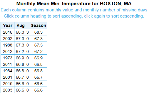
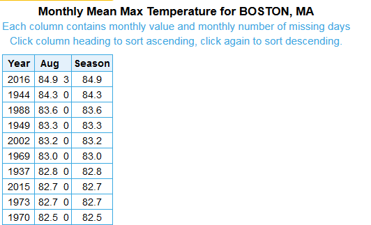
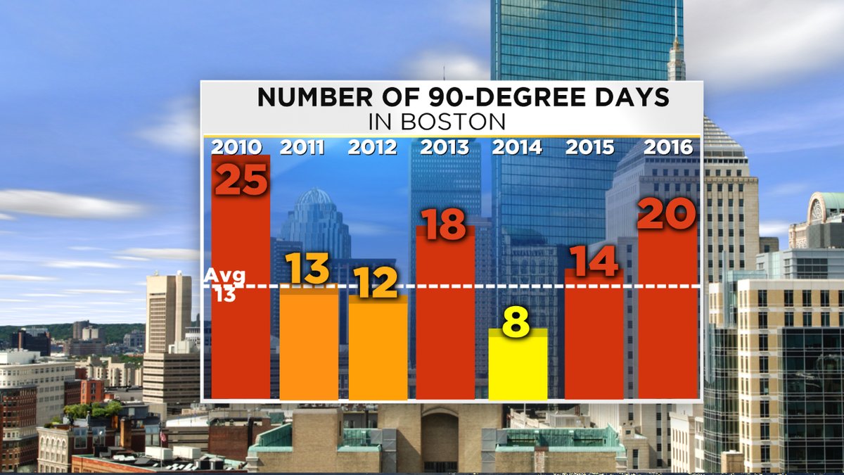
We've been doing it on both ends of the day. Both the mean daytime max temperature for August and mean daily low temperature are ranked #1 in Boston to date. In terms of 90s we still have a ways to go to enter record territory, but it's not completely out of striking distance. Monday was the 20th day to top 90F so far this year in Boston. That's a few behind the scorching summer of 2010, but well shy of the record 30 days in 1983. It would be a tough feat to accomplish, but the outlook says it's not impossible. More on that later.
Also interesting to note the 1983 comparison. That was another year coming off an extremely strong El Nino event. While they're not all exactly the same, our weather has been mimicking 1982-83 fairly closely since early last winter. It was a scorching summer...tying 1949 for the hottest summer season on record in Boston (this year is aiming for 3rd or 4th warmest). It was also very dry, the 10th driest summer for Boston. And since the inevitable 'what was the following fall/winter like' question is naturally coming, here's your answer. That fall was also very warm. On the plus side, it was very wet! We can only hope. And the winter which followed finally brought a return to more typical conditions in terms of both snowfall and cold.
So what's the outlook ahead? I'd plan on more beach time than apple picking time. We're expecting a nice push of pleasant air for Friday through Sunday this weekend, but it's really just a return to 'average' or slightly below...and then the torch will fire back up for most of the month. A resilient ridge will be the main factor for us this September, helping to keep pumping the warm air into New England. Not fun news for teachers and students in AC-free classrooms next week.
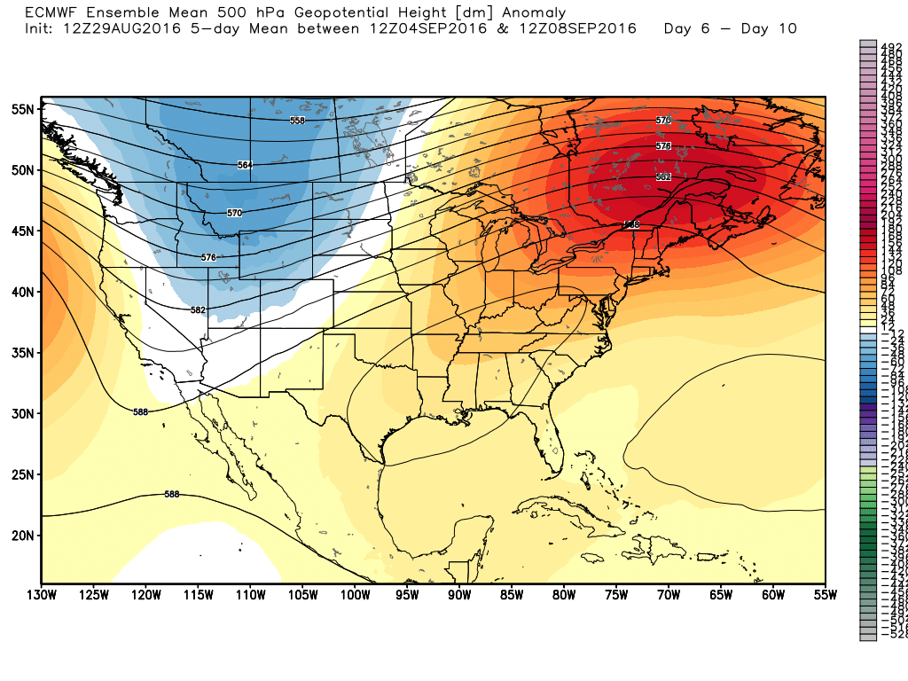 A strong ridge builds over the eastern U.S. next week (September 4th-9th) allowing for a surge of post-Labor Day heat. Source: Weatherbell
This also begs the question - what's warm for September? Color scales on weather maps are built for anomalies, aka departures from average. They don't always truly convey actual air temperatures to the casual observer. Well average highs in Boston drop from 77F to 67F. We're supposed to be getting into the season of chilly nights, a few crisp days, and even frost potential. I doubt we're going to be talking about much of that anytime soon. I'd expect to see plenty of 80s ahead of us, with several opportunities to top 90F in the next several weeks. The drought actual helps - as a dry landscape allows air heat up more easily. We may even make a run at another Top 10 warmest month on record. So in short, I wouldn't take my boat out of the water yet (if I had one), wouldn't shut down early if I had an ice cream shop, and I wouldn't shy away from thinking about a beach trip or two. The only big fall indicator that will come is shrinking daylight. We lose 1 hour and 22 minutes of daylight in September, as sunset goes from 7:17pm to 6:27pm. The lowering sun angle also makes September 'heat' feel more tolerable than July heat, even if temperatures are the same.
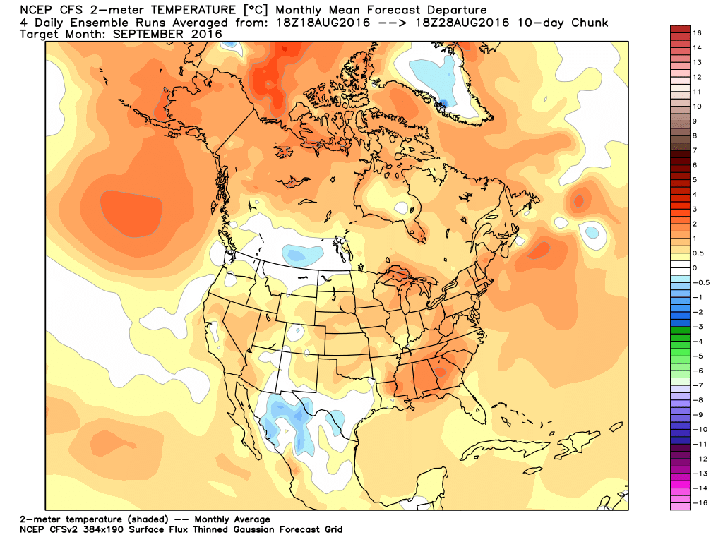
The CFS (which, disclaimer, isn't always great at long range outlooks) keeps the warmth on for the eastern U.S. well into autumn. Though the model doesn't have the best track record, I do agree with a warmer eastern U.S. over the next two months. Source: Weatherbell
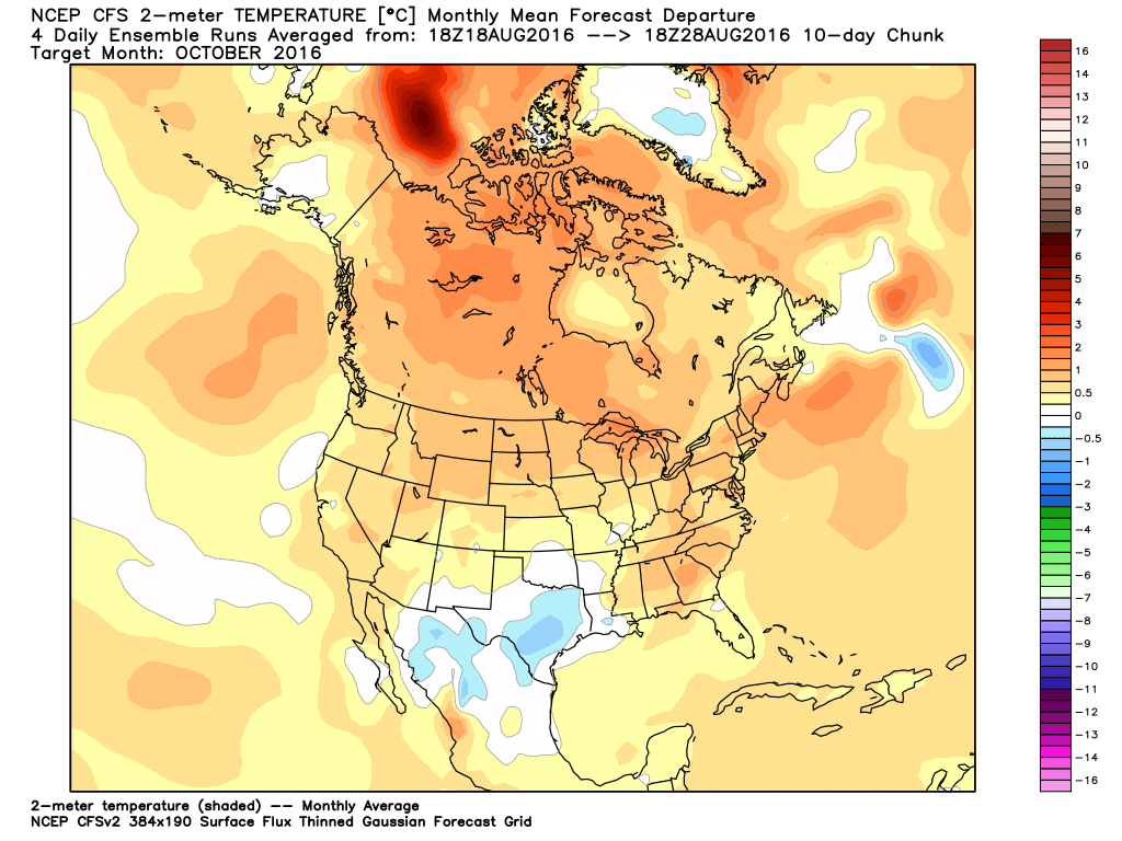
Even longer range, I don't see any wholesale changes for October. I'd call for another warmer than average month, though that's not necessarily a bad thing by the time October rolls around. A bit above average would really just make for a great month of outdoor weather. We probably won't have a shot at bucking the warm trend until we get into winter. We'll have that outlook coming up soon, but the early indicators are for a relatively typical winter in terms of temps and snowfall. Nothing screaming big heat/cold/snow just yet. But the WBZ team will be evaluating over the next month or so and will roll out the full prediction this autumn!


