Drought Continues To Deepen - Little Relief Ahead
The stories of stressed landscapes and even buildings are accumulating much more readily than rainfall these days. This week, a look at Boston's lowering water table and how it reveals the wooden pilings that support much of the city. The town of Scituate is urging people to 'take fewer showers.' A plane landed on a sandbar in the Quabbin Reservoir that likely wouldn't have existed without the dry conditions (which have the water levels about 6% below average for this time of year). The prolonged dry stretch, which dates back to spring 2015, is leaving its mark.
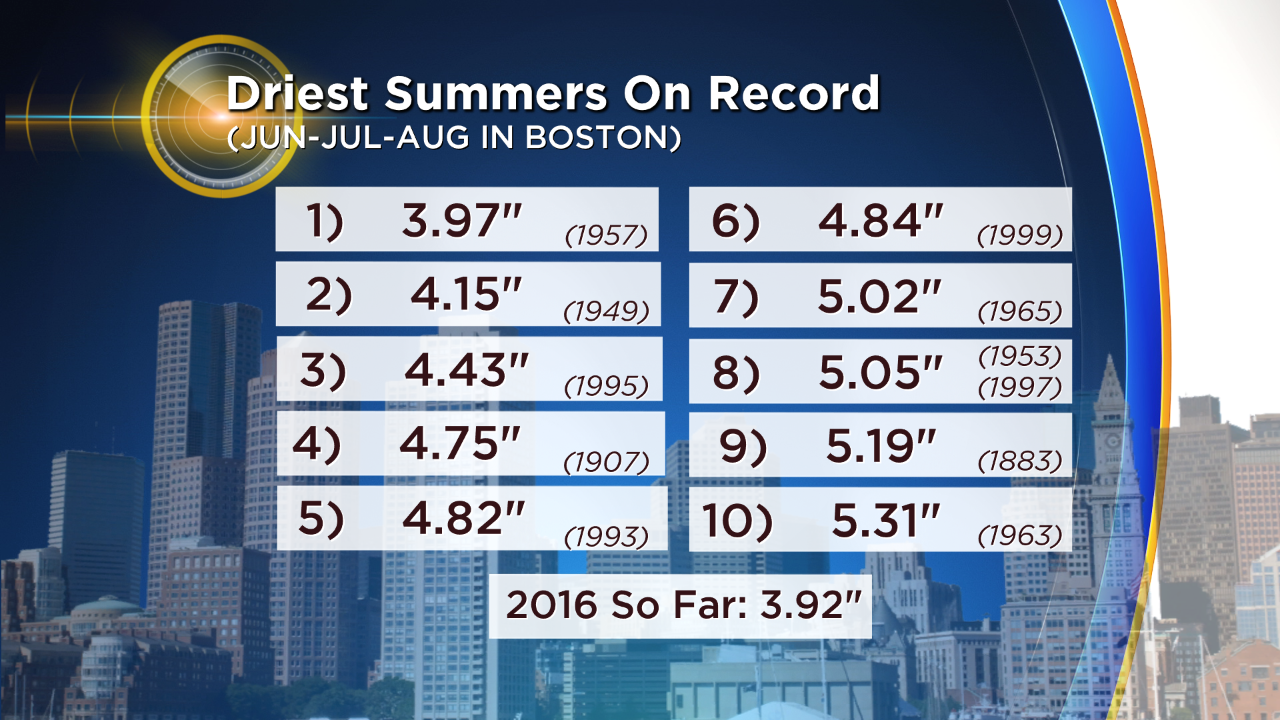
That being said, it's been drier in the past. Much of the area will NOT see its driest summer on record by a long shot. Providence isn't in the Top 20. Worcester isn't in the Top 10. Hartford is at #17 for driest summer. If a quick shower visits Boston tonight, Friday, or Monday...it won't be the driest summer there either. And though we haven't had 'Extreme Drought' on the drought monitor before, it's only been around for 16 years. Not much for a period of record. We'll see where things go in the long run...but it could be worse.
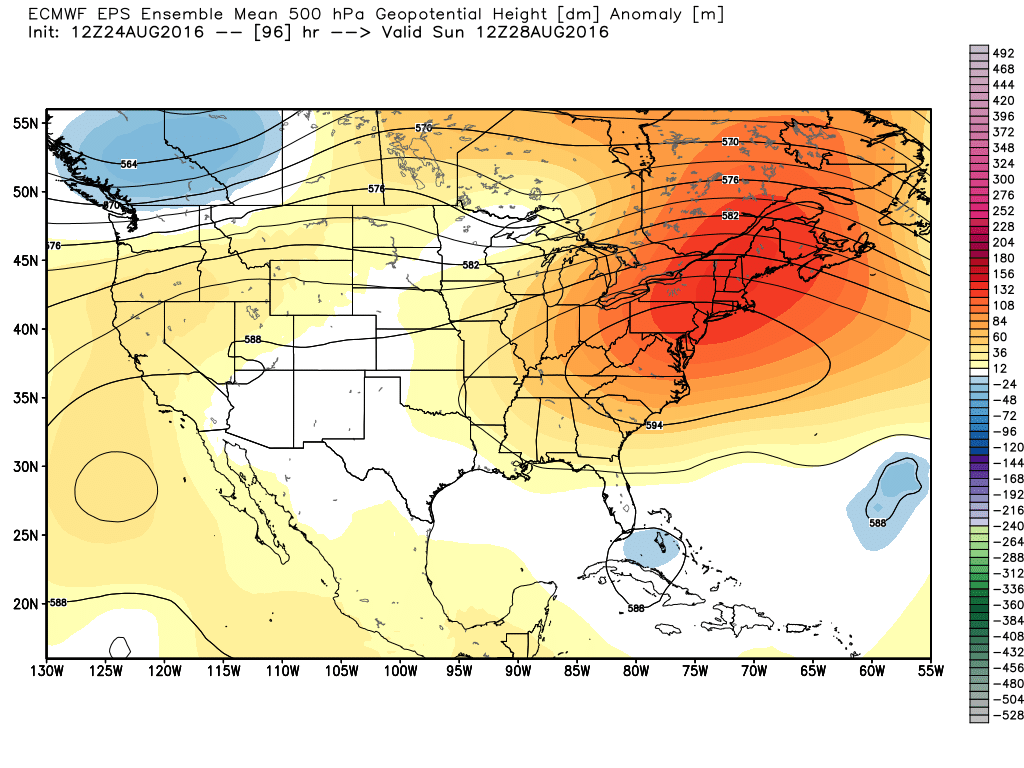
500mb setup this weekend with a large East Coast ridge keeping us dry and keeping tropical intrigue south across Florida. Source: Weatherbell
So let's look at the overall pattern, which doesn't bode well in the short-term. A big ridge is once again taking control of the east, pumping the heat back up and keeping rain chances low. We may be able to get a little overnight instability Thursday night with some scattered showers or a rumble, but I wouldn't bank on much. We have a cold front crashing into very warm and humid air on Friday, but the ridge will help squash storm chances. In essence, it's just too warm. The ridge allows for very warm air aloft, which in turns leads to poor lapse rates (the rate at which air cools with altitude). If air doesn't want to rise, then it's tough to get any good storms going. So that's a major limiting factor for us Friday afternoon. I'd expect widely scattered showers & storms at best.
A bone dry weekend with lots of sun gives way to another weak front Monday...which again probably won't generate much. An isolated storm or two is possible. And then...it's September! Meteorological Summer ends next Wednesday. It doesn't mean the end of beach days, lobster rolls, or tans...but it does mean the weather record books will close on summer. We'll see if any of these low shower/storm chances produce and nudge Boston away from the top spot (driest summer).
 Satellite loop of Invest 99L, which may become 'Hermine'
Looking longer range, the tropics offer at least some minor intrigue. There's still a lot of uncertainty with 'Invest 99', a system currently bringing heavy rain to Puerto Rico and Hispaniola. Disorganized waves like this are notoriously low-confidence forecasts, but the upper-air pattern suggests it has little chance to move north up the East Coast. The same big ridge that brings us heat and dry weather should block its progress, helping to steer it west into the Bahamas and Florida this weekend. It likely won't be a strong system when it moves through, but we always need to keep a close eye on things when tropical systems move over 30C water. If it receives Tropical Storm status, it would be named Hermine (her-MEEN)
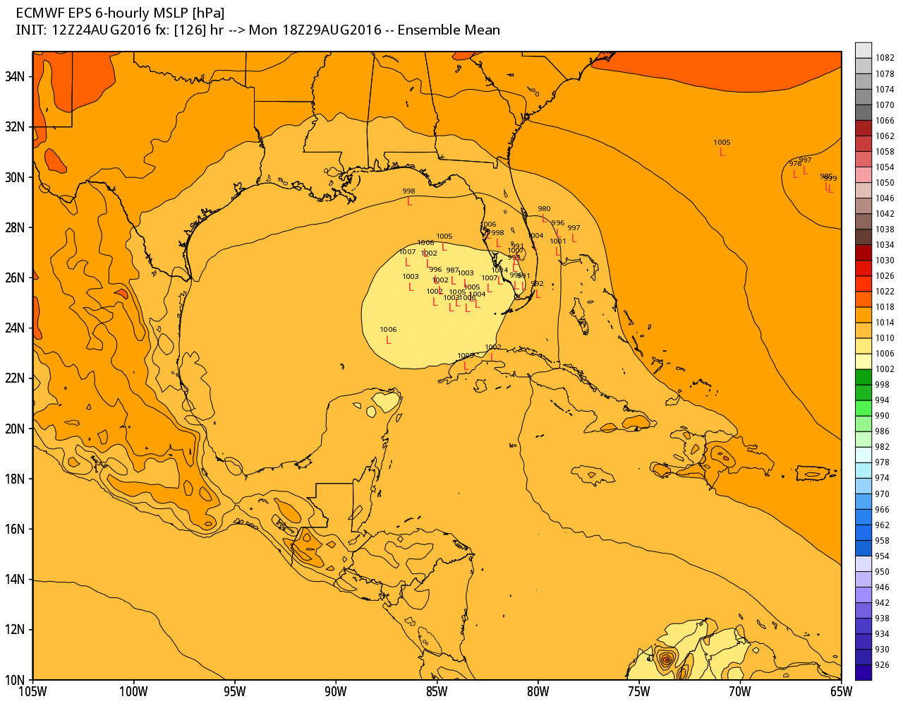
ECMWF EPS continues to show a cluster of solutions bringing a tropical low across Florida and into the Gulf early next week. Source: Weatherbell
After that - the circulation could get into the Gulf of Mexico. IMO, that's the most likely scenario right now. Even in a weak state, anything in the GOM this time of year has a wide range of possible outcomes. It doesn't appear that there will be much wind shear there, and the waters are very warm. Any Gulf Coast state should keep tabs on its progress through the weekend. From that point, the ridge begins to shift east. The big IF - whether or not a storm gets into the Gulf, is what matters for our forecast. The shifting ridge could allow the storm and its tropical moisture to swing around its western periphery and across the eastern U.S. At this point, it's our best shot for any decent rainfall. There's nothing else that screams rain looking well out into the future. So the severity of our drought into September hinges largely on the days ahead and what this system does. If it manages to get into the Gulf and then turn north, the earliest we could expect any rain from it would be at the very end of next week (start of Labor Day Weekend).
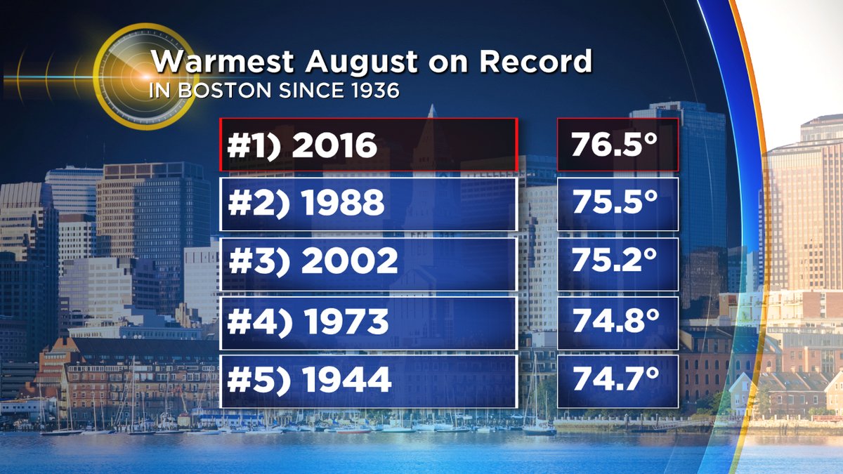
It's also worth noting that it hasn't just been dry, but hot! August is on pace to be the warmest ever recorded in Boston. We're currently a full degree above the record warmest (1988) and we'll increase that lead through Friday. That may be insurmountable considering the few days left in the month, and also considering that Monday should be another day near 90F. The long range calls for a very warm September as a following act, so the back to school sweaters are going to have to wait.