First Heat Wave of 2016 On The Way
Find Eric Fisher on Twitter and Facebook
Sometimes a cool stretch in summer can be a nice chance to recharge. We just wish it would come on a Tuesday-Thursday or bring more rain with it! A weekend in the 60s with only spotty showers/downpours was a good break for the lawns but didn't deliver as much rain as we would like. Boston only picked up 0.2" the whole time. Now the clouds are gone and it's time to heat up with another dry stretch likely leading to persistent drought for July. Plus, we've got a shot at our first official heat wave of the year (3+ days of temperatures 90F+).
The warm-up kicks in on Tuesday with temps well into the 80s. Good news for us - the humidity stays in check here. Dew points in the 50s should make for a beautiful summer day with bright skies and warm air. Not much of a pressure gradient as high pressure will be drifting just offshore, which means we'll likely get some light sea breezes in the afternoon. All told a great day to be outdoors and for enjoying the shore if you've got time off. There's an outside chance a couple towns may start their heat wave on Tuesday, in particular the Fitchburg to Lawrence areas.
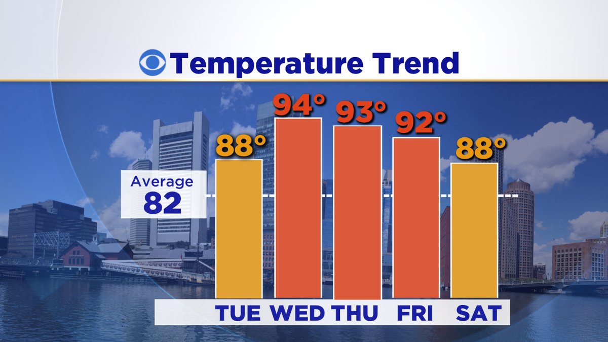
Then we start to get into the true 'Triple H' conditions for Wednesday and Thursday; something we haven't really seen much of. Only two days have reached 90 in Boston so far this summer, which is technically half-over (Meteorological Summer is June-August). The city averages 13 such days in a given year. That being said, we can stack up 90+ days easily from mid-July to early September. The climatological peak of summer heat is the upcoming two weeks, through the end of July. Then we start to cool down, but it's a slow process and there's often plenty of heat left in the tank for August. So if you're salivating for hazy skies and high heat, we're definitely not done yet.
Wednesday's dew points will climb into the 60s, and combined with highs in the low 90s should produce heat index values in the upper 90s. A day to take it easy during the midday and afternoon hours, and to make sure everyone stays hydrated at summer camps, etc. There's a slight chance the NWS may issue heat advisories for part of the area, but it will be borderline. I think we'll probably come up short of criteria.
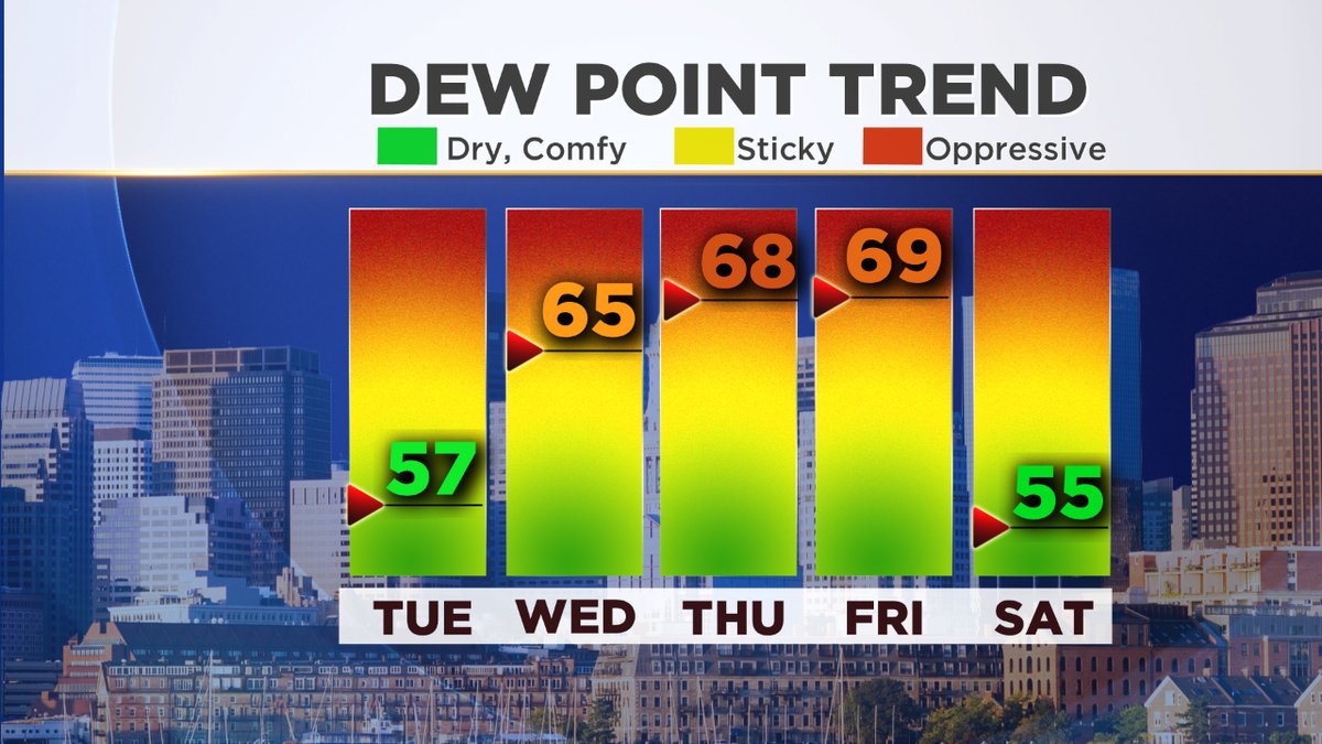
Southwesterly winds will continue to pump humidity up into New England for Thursday and Friday, with dew points topping 70F at times! That's when we fall into the 'oppressive' category where it's difficult for the body to keep cool. So certainly put an emphasis on hydration and avoiding strenuous activity during the middle of the day. With this kind of air in place and a weak trough approaching from the west, we'll likely end up seeing a few afternoon storms pop. On Thursday the highest likelihood of this happening will be well NW of Boston. Anyone in western New England, central Mass, and southern New Hampshire will stand the best chance of seeing some beneficial rain/storms. Severe weather appears unlikely.
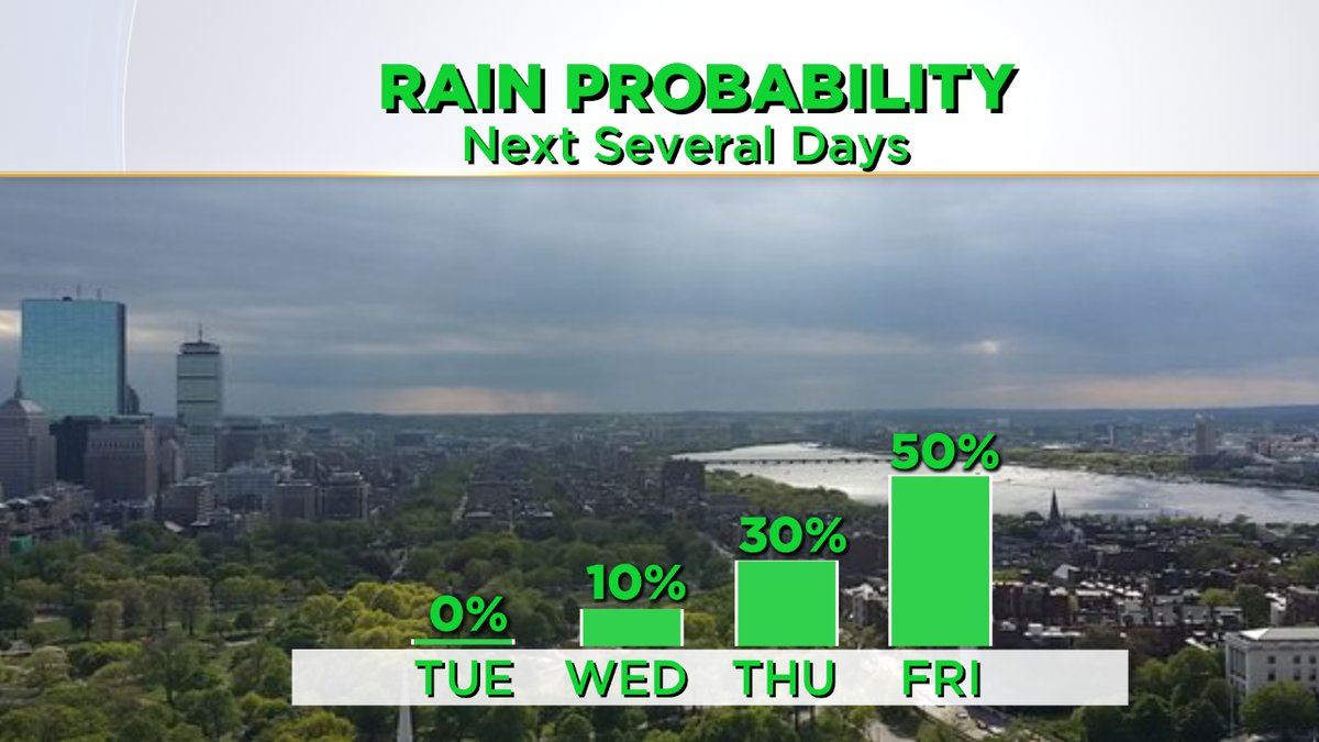
A pre-frontal trough swings through Friday and a trailing cold front behind it by Friday evening/night, which should bring us our best shot for showers/storms this week. Again, it doesn't look like a big severe weather setup. But hopefully we can squeeze out some more rain to ease a hot stretch. Provided we get enough breaks of sunshine on Friday, it should be another day that tops 90 with very high humidity. A tropical end to the work week!
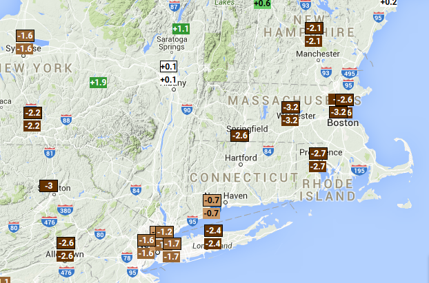
Rainfall deficits across the region since June 1st

