Snow Again - What To Expect Monday
BOSTON (CBS) -- We are living in crazy times! Just two days ago, it was rather muggy with temperatures maxing out in the range of 70-to-75 north of Boston and now it's a winter wonderland!
March Madness certainly is continuing into April and it's not over by any stretch of the imagination.

The pie chart reveals that over the last 126 years of record in Boston, there have been 69 Aprils with no measurable snow, 41 Aprils with 0.1-to-3" of snow and 16 Aprils with more than 3".
Adding in Monday's potential snowfall, this will be the 17th April with more than 3" in the city.
The general profile map of Sunday's snowfall depicts a swath of 4-to-6" west-southwest of Boston. The elevated area of the Blue Hill Observatory received 8" from Sunday's fast and furious storm.
More: Snow Totals From April 3 Storm
HOW WINDY?
The wind will gradually increase Monday up to 12-to-28 miles per hour from the northeast, as the next clipper system dives into the region.
After that, a blustery cold wind of 15-to-30 miles per hour will continue to blow through much of Tuesday from the north-northeast in the morning to the northwest in the afternoon.
There shouldn't be any coastal flooding concern with this next storm either.
HOW ARE THE ROADS?
Roads could become slippery Monday during the morning commute.
However, with mostly light to occasionally moderate snow falling during the daylight hours on an April day, I would expect that most roads will improve quickly with treatment and plowing probably won't be necessary in many areas as the day progresses.
Much of the snow should melt upon contact with paved surfaces. Driveways and some less traveled town streets may be covered with a bit of snow.
There is a concern for a flash freeze with temps falling into the 20s Monday night.
TIMING OF NEXT SNOW & RAIN:
A winter weather advisory is in effect from 3 a.m.-to-8 p.m. on Monday.
Snow will commence between about 6-to-8 a.m. It will be of longer duration than Sunday's storm, lasting 8-to-10 hours.

It will be a steady, mostly light snow and periodically could be moderate in spots. It should become more intermittent from north to south later Monday afternoon and taper off to just scattered snow showers over southeastern Massachusetts Monday evening into the first part of the night in that area.

The snow could mix with some sleet before transitioning to mostly rain primarily across southern Connecticut, southern Rhode Island and most of Cape Cod with a change back to a brief spell of snow on the back-end of the system late in the day Monday and Monday evening.
HOW MUCH SNOW ON MONDAY?
The clipper will produce a swath of 2" up to 4" across much of Massachusetts except the southeastern part of the state and perhaps closer to the northern border of the state.
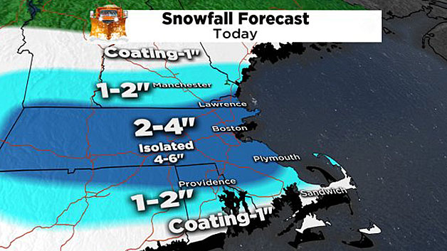
There is a slight chance that there could be a few isolated totals of 4-to-6" or so in that swath ranging down to no new snow or just a coating closer to the south coast after the rain turns back to snow late in the day.

HOW COLD WILL IT BE?
High temperatures for the next 2-to-3 days will be running 15-to-20 degrees below average for this time of the year. That means low 30s Monday and mid-30s on Tuesday.

The low temperatures will be near record lows on Wednesday noting the above map, courtesy of WeatherBell. It is displaying a ridge of high air pressure poised right over the region.
Consequently, with clear sky and diminishing wind Tuesday night, the stage is set for some decent radiational cooling over the fresh snow cover from these two storms.
That snow will not have all melted by Tuesday night in most locations. Boston's record low for April 6 is 20 degrees set in 1881. That will be a close call in the city, while the suburbs are all in the range of 10-to-16 degrees.
WHEN WILL IT WARM UP?
The upper air steering currents will abruptly change by late Wednesday and Thursday as this map reveals a southwesterly flow of air aloft and the warming will be dramatic, so expect temperatures returning to the 55-to-60 degree range for both Thursday and Friday, with showery periods.
As Mark Twain's old saying goes, "If you don't like the weather in New England now, just wait a few minutes."