70 To Snow? Winter Weather Returns This Weekend
There's nothing about New England spring that lets you get comfortable for long. It develops in fits and spurts, as the atmosphere starts its maturation to warm-season form. Kind of like watching a toddler grow up if you think about it. Temperamental at first, not sure what it wants. Then finding the path and moving toward its steadier summer life. And like watching a kid grow up, there are days when you want to rip your hair out. This weekend may provide one of those moments.
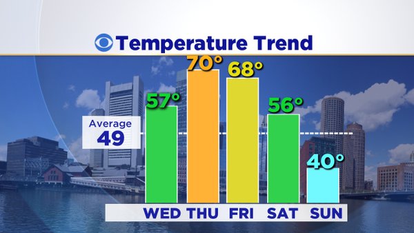
Let's start with the warmth first. Loads of strong late-March sun will help bring us well into the 50s on Wednesday - by far the pick of the week! Get your golf or baseball practice in with less wind and comfortable air. The end of the week looks even warmer, so why isn't Thursday or Friday the pick? Wind, and lots of it. A strong south-southwesterly flow will set in for Thursday and Friday, which should help to produce gusts in the 35-50mph range! Much less enjoyable to be outdoors, even with the warmth.
Also on the docket to end the week is a stormy 24 hours from Thursday evening through Friday evening, as unusually high levels of moisture stream northward into the region. We should be in and out of scattered showers and downpours, culminating on Friday. I wouldn't be surprised if we end up with some thunder and lightning during the day with a warm and muggy air mass in place and a cold front approaching. Highs will be well into the 60s with dew points also around 60F. Rain totals should end up in the 0.5-1.5" range for the event. It's good that we've kept up these rain events every few days, because there's no snow to melt. Without it the ground would quickly dry out just as plants need the moisture to start growing. It's also helping to keep brush fire season in check so far.
Saturday is our transition day between the Friday storm and the cold blast ahead. Many of us still reach well into the 50s before the arctic front races in from the west. So if you're trying to get in one more long training run for the Boston Marathon, Saturday morning is definitely the way to go.
Okay...let's talk some cold. This arctic boundary is being pushed forward by a very potent shortwave disturbance. It's not only cold, but quite energetic. So as the winter air pours in on Saturday night, it should be accompanied by plenty of snow showers and squalls. These will be most likely across Vermont, New Hampshire, and Maine - which is great news for late-season skiers trying to get in the final few turns of 2016! There's a good shot at several inches of snow for many of the mountains with this system...and an outside shot of localized 6" totals. Around here in southern New England? The best chance of accumulating snow will likely be across higher terrain of Worcester County and southern NH. But I think we'll max out at coatings to a couple inches overall. A bigger deal may be some areas of poor visibility as the squalls move through for overnight/early Sunday AM travel.
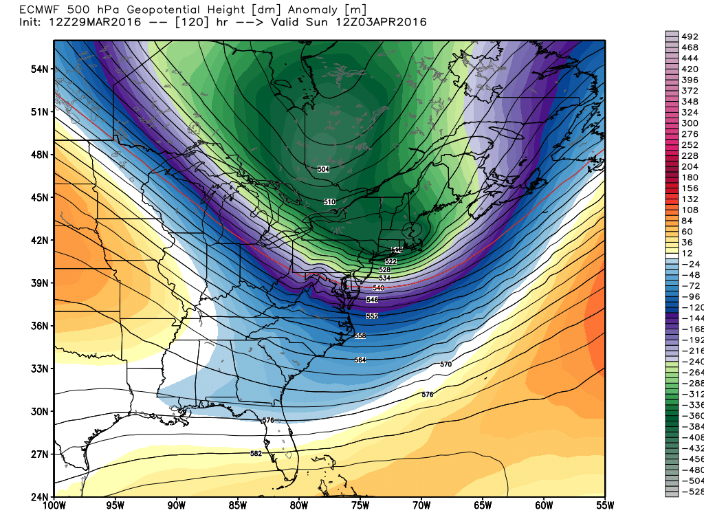
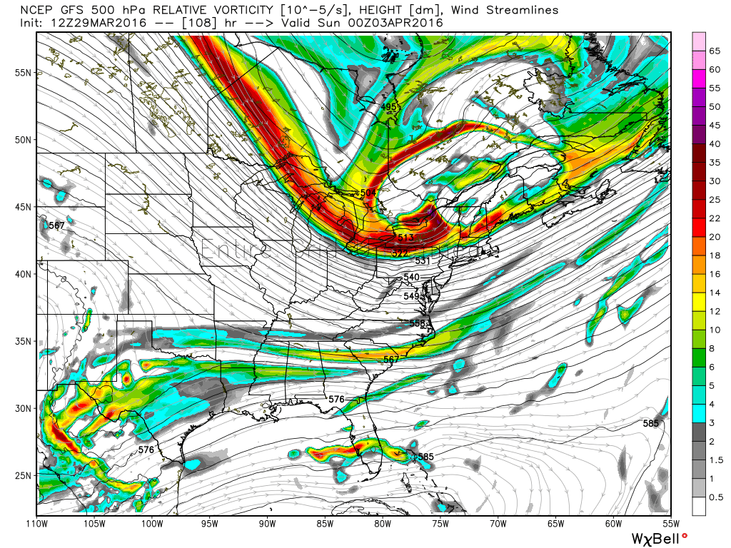
A highly anomalous trough digs in right over New England on Sunday. Source: Weatherbell
Temperature wise - we all get interested when we see weather maps with deep purples and pinks on them. Barney's coming! Those maps are usually showing temperature anomalies, which can translate to different impacts depending on the time of the year. Temps 20 degrees below average in January hurt a lot more than 20 degrees below average in April. Average highs are in the 30s in January, but 50s in April. Plus, the higher sun angle and increased daylight can work wonders on how a certain temperature feels. So keep that in mind when seeing these maps - they're not all created equal.
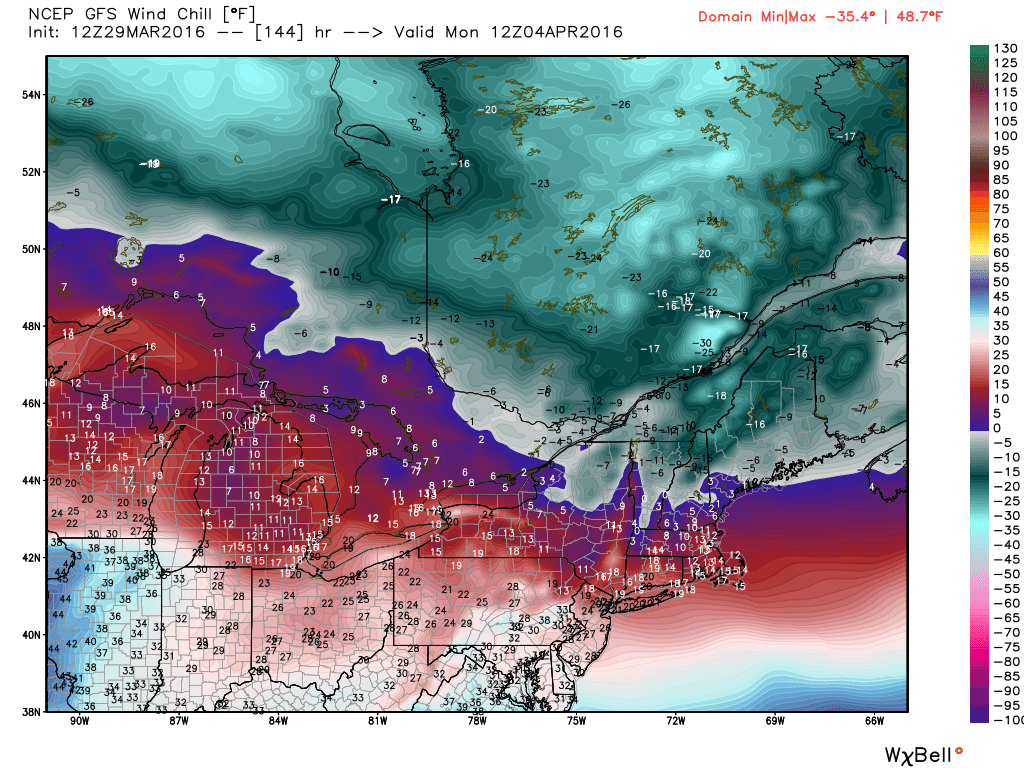
GFS guidance for wind chills Monday morning. Not a fun one at the bus stop. Source: Weatherbell
However, it'll be quite cold by April standards Sunday through at least Tuesday. Highs for many won't escape the 30s during this stretch. Not bitter mid-winter cold, but not what you want to see in April. It looks like Sunday night and Monday night should drop into the 10s and 20s, with wind chill values in the 0s and 10s. This is worrisome not because we can't handle it, but because all the warmth this winter and early spring has woken up plants well ahead of schedule. I'm concerned that many early-season blooms may come out by Saturday, and then be killed off by the cold. Most forsythias should be out by then, as well as daffodils and perhaps some of the early flowering shrubs/trees like cherries. With some luck, perhaps some of these will stop short of bloom before Sunday or the harshness of the cold will diminish as we get closer. But if not, there could be some significant damage. Hardy plants can fend of a few hours in the 20s, but multiple hours in the 10s/20s would be bad news. It's a storyline we'll have to monitor over the coming days.
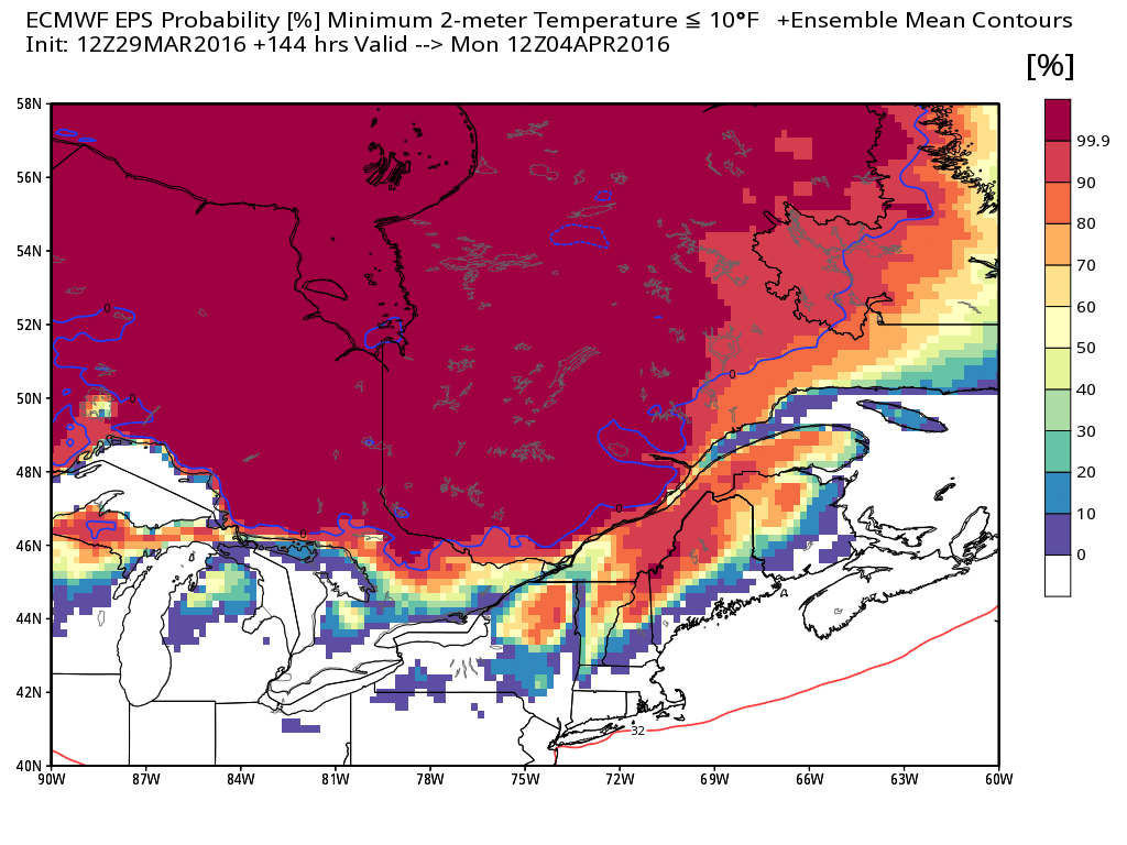
ECMWF EPS probability of temperatures below 10F on Monday morning. Looking extremely chilly for April across northern New England! Source: Weatherbell
Then we come to a more significant snow chance late Monday into Tuesday. Model guidance has been hinting at the development of a clipper during this time frame. These clippers aren't blockbusters, but they can lay down a pretty good track of snow if the timing and placement are right. The pattern looks good for one to develop and we'll have plenty of cold in place to see mainly snow if it materializes. Much too early to be talking totals etc. but keep it in the back of your mind that the shovels may need to be ready again! As previous blog posts noted, this cold period has been on the horizon for quite some time now and we highlighted April 2nd-10th as the best chance for some more snow before the season wrapped up. Have been advising many a plow operator to keep the plows ready until we clear this hurdle just to be on the safe side.
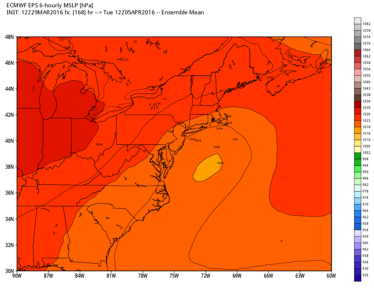
The Euro EPS is on to a low forming south of us...likely not a major storm but one capable of plowable snow. Operational models have also been showing a similar solution. Being 7 days out, there's still room for change. Source: Weatherbell
How rare is late season snow? I must admit I was a little surprised to see how many 6"+ snowstorms have visited Boston in April! There have been 8 of them since 1891, the last of which was the infamous April Fool's Blizzard in 1997. I would have thought it was an extreme rarity for the city, since records are kept at Logan Airport on the water. Usually it's one of the least snowy locations compared to inland areas that don't have to deal with the influence of the ocean.
After this stretch of cold and snowy chances, it looks like the air will start moderating by the middle to end of next week. Warmer air makes a comeback heading toward mid-month, so this may be the final gauntlet to get through. And you know how spring snow goes - doesn't stick around for long. But be prepared for some moments of #SpringFail frustration Sunday through Wednesday!