Snow, Ice, Rain, Wind Will Make A Mess Of Several Commutes This Week
BOSTON (CBS) - Wash, rinse, repeat.
Many times the atmosphere tends to get stuck in a certain pattern. It was just about this time last week when I was writing a very similar blog about a very similar storm on the way. I guess you could call this meteorological deja-vu. We've got another "kitchen sink" type storm on the way, complete with all the "wintry mix" ingredients.
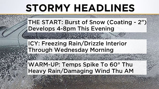
Much like our storm of last week, it will begin with a burst of snow.
Much like last week after a coating to a few inches it will transition to rain in southeastern Massachusetts and inside of I-95 and to an icy mix inland.
Much like last week, there will be a lull in the precipitation while warmer air streams overhead.
And last but not least, much like last week, the grand finale will consist of some very heavy rain, gusty winds and a temperature spike to near 60 degrees.
A few differences of note this go around - there is no Arctic air to dislodge (you may remember the insane cold over the weekend that preceded our last event), and thanks to school being back in session in Massachusetts, there are a lot more cars on the roads this week.
If you are a daily commuter, strap on your seat belt and find your happy place, it could be a long week with several commutes adversely affected by all sorts of weather. Your driving skills and your physical and mental condition will undoubtedly be tested over the next few days.
CHAPTER 1: The burst of snow
Tuesday evening through Tuesday night
Snow arrives from south to north after 4 p.m. Tuesday.
First flakes will fall:
Between 2-4 p.m: Connecticut, Rhode Island and The Berkshires
Between 4-6 p.m: Worcester County, southeast Mass., Cape and Islands
Between 6-8 p.m: Rest of southern New England, including Boston, the North Shore and southern New Hampshire
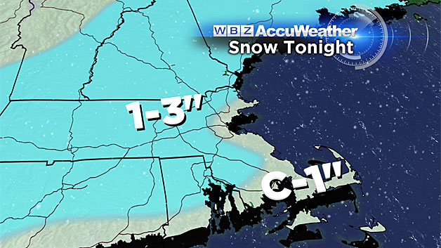
Snow Amounts:
Widespread coating to an inch of snow expected from the upper Cape through southeast Mass. and into Boston.
Widespread 1-to-3 inches west and north of Boston, isolated 4 inches possible, most likely in Worcester County.
CHAPTER 2: The wintry mix
After Midnight, through Wednesday morning
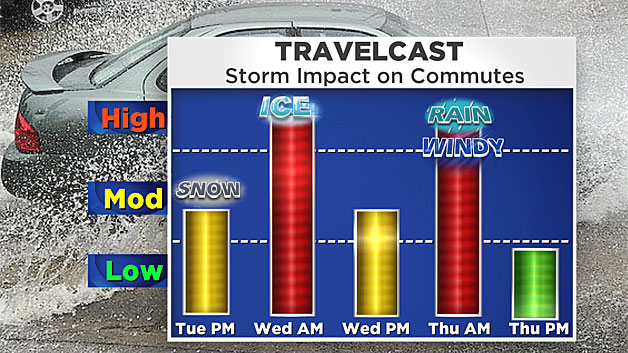
The snow won't last very long at all over southeastern Mass. and along and east of I-95. It will change to rain before midnight in most of these locations.
It will be a slower and icier transition west of I-95 and especially north and west of I-495. After midnight the snow will change to sleet and freezing rain, adding a crusty topping to the fresh snow.
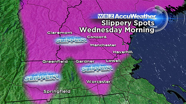
It will be a slow and slippery Wednesday morning commute in many locations.
Along the immediate coastline, including Boston and all of the South Shore and Cape, temperatures will be above 32 degrees and roads will just be wet.
However, most areas inland of I-95 will be right around or just below 32 degrees. A mix of sleet and freezing rain will fall for several hours between midnight and 7 a.m. in most of Middlesex County, Worcester County and southern New Hampshire. Any untreated roads and surfaces will become very slippery.
CHAPTER 3: The lull
Is it over? Not quite yet.
Daytime Wednesday from about 7 a.m. to 4 p.m.
Not much precipitation falls in this time frame as the first wave of this storm passes by and we wait for the main storm system to arrive from the Ohio Valley.
Temperatures will be stuck in the 30's for a good portion of the day on Wednesday north and west of Boston as warmer air initially flows just overhead. Periods of light rain will persist during the day, but less than .5" of liquid. Road conditions will steadily improve as temperatures tick up a few degrees.
CHAPTER 4: Wind, rain and warmth
Wednesday night – Thursday morning
During the evening commute on Wednesday, just some pockets of rain, temperatures solidly above freezing for most of southern New England. Later Wednesday night, a band of very heavy rain arrives along with some gusty and perhaps damaging winds.
Timing the heaviest downpours:
Between midnight and 2 a.m: Western New England including Hartford and the Berkshires.
Between 2-5 a.m: Worcester County, Middlesex County
Between 5-8 a.m: Eastern Mass., including Boston, the entire coastline and the Cape and Islands
Much like last week, there is a chance of a few rumbles of thunder within these heavy rain bands.
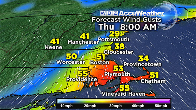
Wind gusts between 35 and 55 mph are possible, leading to some tree damage and scattered power outages.
Finally, temperatures will surge well into the 50's by dawn Thursday, likely falling just a few degrees shy of records for the date (Boston record: 65 in 1930).
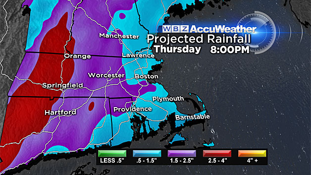
Total rainfall: Widespread 1-to-2 inches, isolated spots up to 3 inches. Not enough for any river flooding, but urban/street flooding is very likely.
WHAT'S NEXT?
It looks much quieter through the weekend. No immediate flash freeze, no significant storminess.
A few weaker storms may pass to our west early next week, drawing up more mild air. We could see a few more days with temps in the 50's!
Watch: Terry and Danielle Niles discuss the forecast:
Follow Terry on Twitter @TerryWBZ