Snow Storm To Bring Blizzard Conditions To Southeast Massachusetts
BOSTON (CBS) - Nothing like a nor'easter to start a work week! This will come as little comfort to many living along the coastline, but we are actually dodging a major bullet Monday. Had this storm taken a track typical of so many of our great nor'easters, it would have been historic.
The center of the storm was showing an "eye" formation at its center Sunday night. In a word, this storm is an absolute beast. Its' center will pass several hundred miles to our southeast Monday, putting southern New England on the very outer fringe.
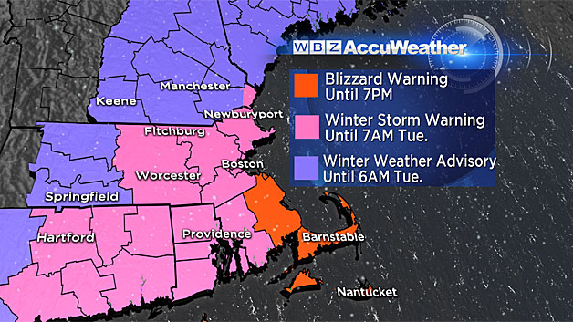
The greatest concern with this event will be the blizzard conditions (powerful winds and falling/blowing snow) in southeast Massachusetts and over the Cape and Islands. Travel is not recommended during the daylight hours Monday in the blizzard warning area with whiteout conditions expected at times.
TIMELINE:
Through 8 a.m:
Snow will move from the South Shore up through Providence and Plymouth, nearing the Massachusetts Turnpike by 8 a.m. Winds will continue to increase and the visibility will rapidly deteriorate over Cape Cod and the Islands.
8 a.m. to 10 a.m:
The snow overspreads the remainder of eastern Massachusetts, into Worcester County and through the North Shore. Heavy snow bands rotate onshore in Barnstable and Plymouth counties.
10 a.m. to 4 p.m:
The "peak" of the storm. When the majority of the snow accumulation occurs. Steady and at times heavy snow falls in all of eastern Massachusetts. Again, heaviest snow and strongest winds in southeastern Massachusetts. Blizzard conditions in that region.
After 4 p.m:
Snow continues across the area but lighter in intensity. Snowfall accumulation slows considerably and winds begin to turn more northerly and with a bit less ferocity. While the snow will continue for most of the night, it will get lighter and spottier after midnight, with just a few flurries left Tuesday morning.
SNOW AMOUNTS:
9-to-12 inches:
The highest snow totals will be in southeast Massachusetts including Plymouth and Bristol counties as well as the Cape and Islands. There will likely be some ocean-enhanced snowbands in this area, these highly localized bands of snow could cause a few towns in southeast Mass. to go over the foot mark.
6-to-9 inches:
Norfolk County, Suffolk County (Boston) and all areas inside Route 128, including the North Shore and Cape Ann.
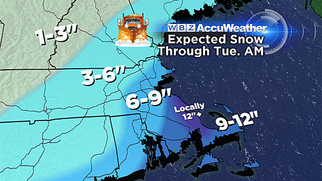
3-to-6 inches:
Most of the 495 belt north of the Mass Pike, and points west to Worcester County and southern New Hampshire.
1-to-3 inches:
Areas north and west of Worcester County.
WINDS:
A major factor with this storm will be the powerful northeast wind gusts. Once again the worst hit area will be Plymouth County, Cape Cod and the Islands where gusts will range from 45-to-65 mph Monday.
Farther north along the Coast from Boston to the North Shore, gusts will range from 30-to-45 mph.
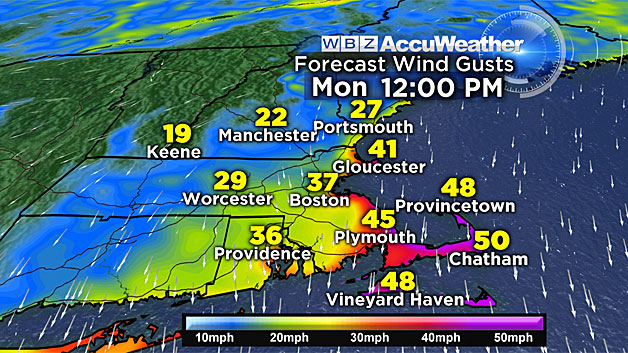
Across the interior, winds will be gusty but not nearly as powerful, gusts 20-to-40 mph at times.
Given the already stressed trees due to our last heavy and wet snow on Friday, numerous power outages are again likely with this event.
COASTAL FLOODING:
The area of concern once again - the Plymouth County coastline, Cape Cod and Nantucket. We expect minor to moderate coastal flooding here between 9 a.m. and 1 p.m.
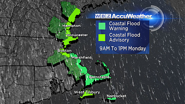
A 2.5-to-3 foot storm surge is currently forecast. Combine that with winds gusting to 65 mph and waves to 20 feet just offshore and you have the recipe for significant splash over and beach erosion.
Minor coastal flooding is forecast from Boston and points north along the coast.
WHAT'S NEXT?
First the snow. While the majority of the snow will fall on Monday, some snow will likely be in the air Tuesday and Wednesday as well. Then comes the cold, the most brutal air since last winter will drop out of Canada later this week. Next weekend looks absolutely frigid. High temperatures in many areas could be stuck in the single digits by day, dropping below zero at night.
This storm should not be underestimated. I would urge that you stay tuned to updated forecasts and rethink travel plans on Monday especially if you are headed towards the coastline. Stay with WBZTV, WBZ NewsRadio 1030 and CBSBoston.com throughout the storm, we will have you covered.
Watch: Terry, Danielle Niles and Pamela Gardner discuss the forecast
Follow Terry on Twitter @TerryWBZ