Blizzard-Nor'Easter Kicks Off Snowiest Week So Far This Winter
BOSTON (CBS) -- After a slow and mild start to winter, we are making up for lost time quickly this February.
Boston has had nearly 7 inches of snow so far this month, while Worcester is already over a foot. This coming week will be the coldest and snowiest week so far this winter.
Check: Parking Bans and Snow Emergencies
First the snow. While the majority of the snow will fall on Monday, some snow will likely be in the air Tuesday and Wednesday as well. Then comes the cold. The most brutal air since last winter will drop out of Canada later this week. Next weekend looks absolutely frigid. High temperatures in many areas could be stuck in the single digits by day, dropping below zero at night.
So that's the big picture, for the remainder of this blog we will focus on the most significant even of the week, a Monday Blizzard/Nor'easter.
TIMELINE:
The snow will encompass most of eastern Massachusetts by 7 a.m. on Monday. Many kids will enjoy a four day weekend, having been off Friday for our last storm and again on Monday.
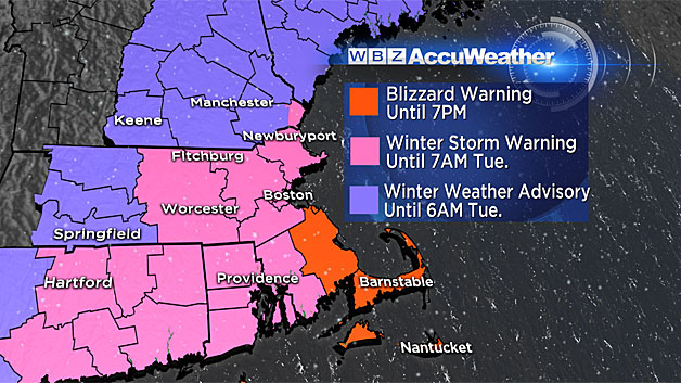
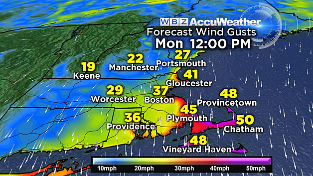
The snow will come down hardest during the daylight hours on Monday. Blizzard conditions are likely in coastal Plymouth County and over the Cape and Islands. Blizzard conditions refer to the wind and visibility. Frequent gusts of 30-to-50 mph, along with falling and/or blowing snow, will cause near-zero visibility in those blizzard-warned areas. Travel is NOT recommended in the blizzard warning area on Monday.
There may also be some ocean enhancement to the snow, due to very cold air flowing over the relatively mild ocean. This will be seen in some thin bands over southeast Massachusetts on Monday. Within these bands, snowfall rates could reach 1-to-3 inches per hour!
By Monday evening, the snow rates will taper and the majority of the snow accumulation will be done.
SNOW TOTALS:
So how much are we talking?
The "jackpot" area looks to be in southeast Mass., Plymouth County, and Cape Cod.
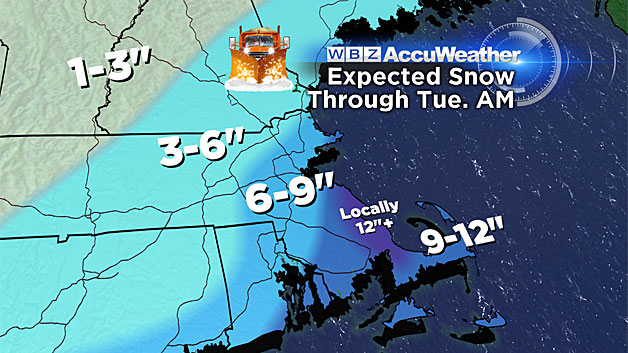
We are forecasting a conservative 6-12 inches there, however there may be some locally higher amounts (within the ocean enhanced snow bands) up to 18 inches!
For the remainder of inland southeast Massachusetts, Boston, the North Shore, and areas inside of I-495, we are forecasting 6-12 inches as well.
Farther north and west, beyond 495 into Worcester county and southern New Hampshire, snow amounts will be lower, 3-to-6 inches and tapering quickly to 1-to-3 inches into central and northern New England.
COASTAL CONCERNS:
This will be the first real test of our coastline this winter. Tides will be astronomically very high on Monday. The late morning high tide is the primary concern, between 10 a.m. and 1 p.m. Moderate coastal flooding is likely, especially along the South Shore and Cape Cod.
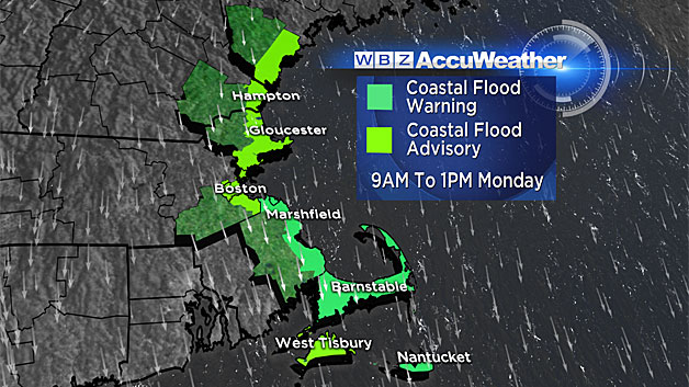
Significant beach erosion will occur in these areas as well.
WIND DAMAGE-POWER OUTAGES:
With trees already being stressed from our last heavy snowfall, the additional snow and wind from this storm will create a significant concern for wind damage and numerous power outages.
This storm should not be underestimated.
I would urge that you stay tuned to updated forecasts and rethink travel plans on Monday especially if you are headed towards the Coastline.
Stay with WBZ-TV, WBZ NewsRadio 1030, and CBSBoston.com throughout the storm--we will have you covered.
Follow Terry on Twitter @TerryWBZ