Several Inches Of Plowable Snow Falls Across Southern New England
BOSTON (CBS) - Here we go! A widespread, plowable snow event is underway in southern New England.
Live Blog: Discuss The Storm With WBZ AccuWeather Team
Right on schedule, the rain changed to snow across the area and driving conditions deteriorated quickly.
Here is the latest forecast:
TIMELINE:
Steady, accumulating snow will continue through early afternoon, with rates as high as an inch per hour at times.
By 1 p.m., the back edge of the snow will begin to make progress eastward and the snow will taper off from west to east. Snow will end in Worcester by about 2 p.m. and Boston by about 4 p.m. The final snow bands will exit the Cape between 5 and 6 p.m.
SNOW AMOUNTS:
A widespread 4-to-8 inches of snow for most of eastern Massachusetts. As with just about every storm, there will always be some overachievers.
For this storm that area will be in northeast Connecticut, northern Rhode Island and a large portion of Worcester County and western Middlesex and Norfolk counties. These areas could top 8 inches and reach 10 or 12.
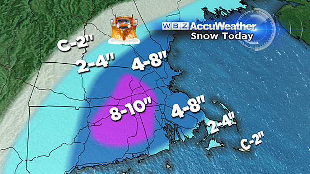
For the most part, snow totals decrease the farther north and west you travel outside of 495. West of Worcester County and Hillsborough County in New Hampshire snow totals will only be 2-to-4 inches with just a coating to 2 inches in far western Mass. and most of central and northern New England.
Due to a later changeover from rain to snow, Cape Cod and the Islands will also receive less snow, between 2-to-4 inches of heavy, wet slop. Portions of extreme outer Cape Cod and Nantucket will only see a coating to 2 inches.
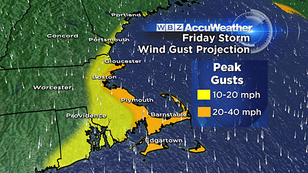
WIND:
While not a major concern in this event, the winds will be a bit gusty at the immediate coastline, especially over Cape Ann, the South Shore and Cape Cod and the Islands. Gusts 20-to-40 mph are likely in these areas.
COASTAL FLOODING:
There is no concern of any flooding at the coast line with this event. Mid-morning high tides should pass uneventful.
POWER OUTAGES:
Due to the heavy, wet nature of this snowfall, there is a risk of some isolated power outages. Without any significant strong winds, the threat remains relatively low.
SLIPPERY TONIGHT:
Temperatures will drop well below freezing everywhere tonight.
Overnight lows will be in the teens for most of the suburbs. Any untreated surfaces will become very slippery.
WHAT'S NEXT:
A quiet weekend with daytime temperatures near or slightly above 40 degrees will help to melt some of the snow left on the pavement.
We have been watching the long range for the potential of a significant winter storm early next week. If all the ingredients come together, this could be a nor'easter-type event Monday night and Tuesday.
Either way, next week will be much more "wintry" with a significant shot of Arctic air blanketing much of the central and eastern United States.
Watch: Terry, Danielle Niles and Pamela Gardner discuss the storm
Follow Terry on Twitter @TerryWBZ


