State Of The Winter, El Nino Update, And Other Weather Tidbits
BOSTON (CBS) - Well it's February, honey bees have been spotted in some towns, bulbs are poking out of the ground again, and we're starting the month with a string of 50+ days.
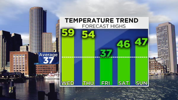
Oh and we can't forget Phil, who says spring is coming early. Naturally a quadruped must know what he's talking about, no? Sorry Phil, but don't write the eulogy for winter 2015-16 just yet. There are some interesting times ahead of us, particularly next week. So let's take a look at where things stand and what's on the table for the weeks to come.
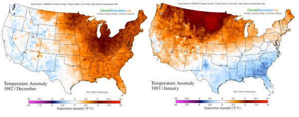
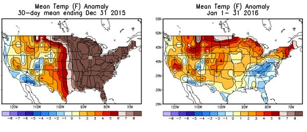
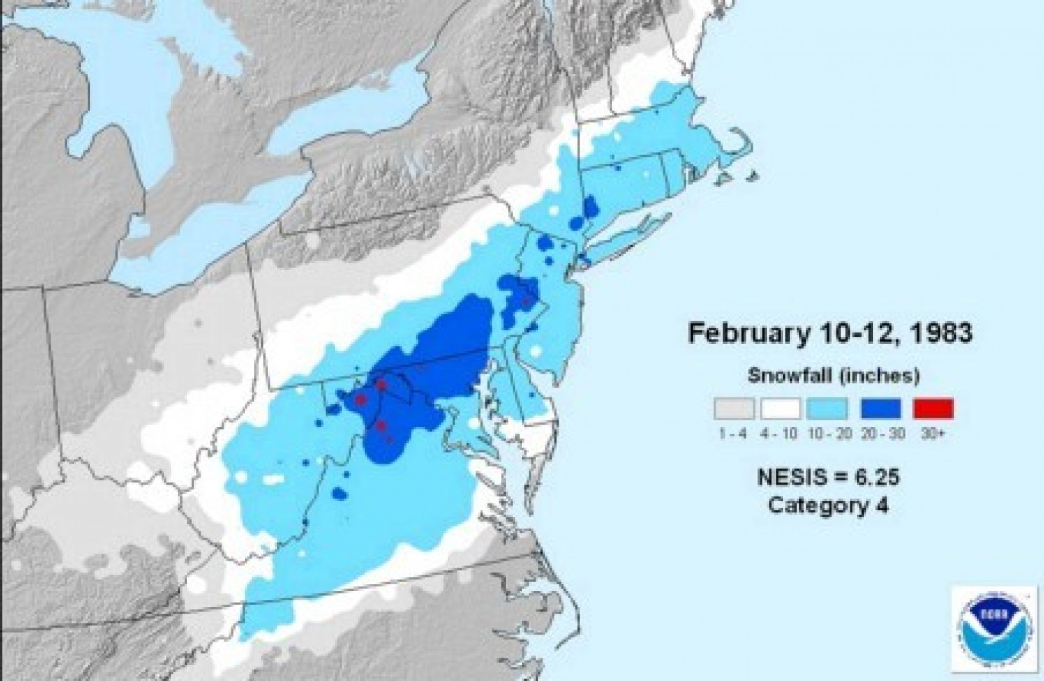
First off, I continue to notice that this winter's temperature pattern has been nearly identical to the strong El Nino in 1982-83. I brought this up on some past blog posts when we were seeing warm conditions in November and December. No two El Nino events are alike, and you can't broad brush all of North America with a standard 'El Nino' one size fits all forecast. But these two events have been strikingly similar. The temperature anomalies have been warmer for most this year, which is not overly surprising considering the world is a slightly warmer place than it was 30 years ago. But the placement of the warmer and colder temps vs. average is nearly spot on. So what happened in February of 1983? It, too, was warmer than average in New England (like this February will be). But there was also one heck of a blizzard. In fact, a blizzard almost exactly the same as the one we just saw in the Mid-Atlantic up to southern New England. The only difference was that the Megalopolitan Blizzard of '83 came up about 30 miles farther north.
Source: NOAA
There's no question this winter will wind up well above average in New England, no matter what happens in February. We're on pace for the warmest ever recorded across the region, and this first week will most certainly keep us in the top spot. In fact our departures will be so big after this first week that it will take some serious consistent cold just to come close to overcoming the warm start and getting back to 'average.'
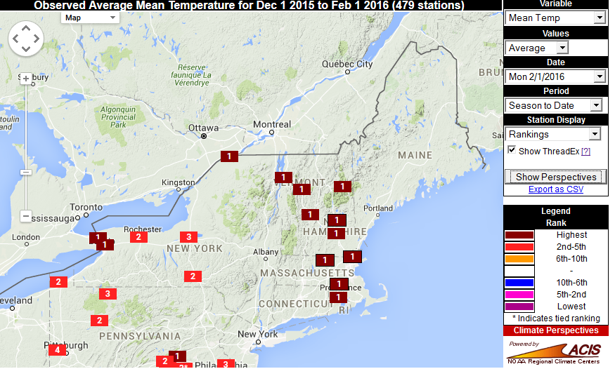
Current rankings for Meteorological winter (Dec-Jan-Feb). Source: Southeast Regional Climate Center
How strange has it been? Well, before you say it's so much warmer now than it used to be, let's look at the most 50+ days we've had in February. The record is 12, and it was set in back 1925 and 1976. Yes, it was warm then too. Sometimes the factors just align to produce anomalous conditions. We'll be at 4 of them after Thursday, and may not see another one until at least after the middle of the month. Looks like a tough record to capture, which is just fine.
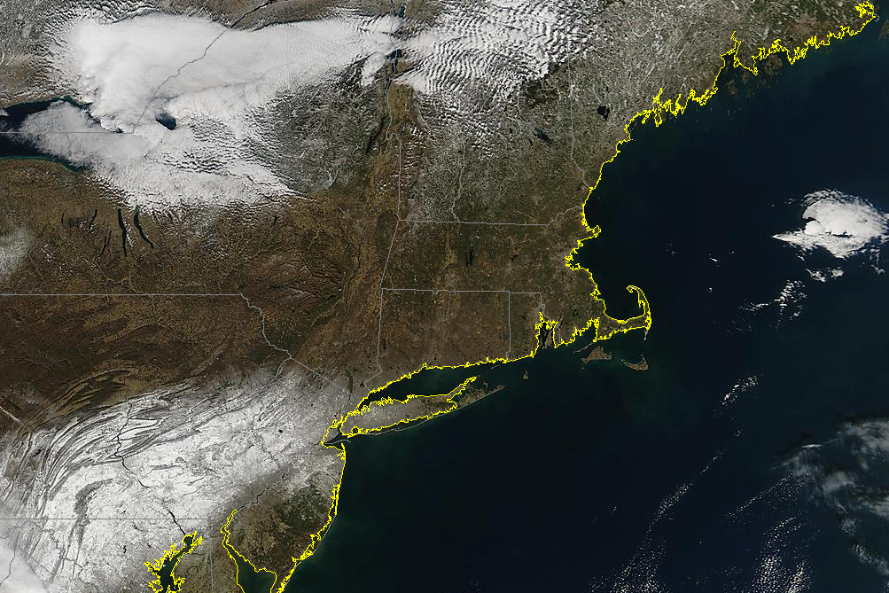
Tuesday's satellite image showing no snow on the ground across southern New England, and not much in northern New England for that matter. The remnants of the Blizzard of 2016 are seen from Long Island down into Maryland. Source: MODIS
Is the lack of snow surprising? No, not really. The outlook for this winter was for below average snowfall (my guesstimate was 32" in Boston) and the general consensus was that if we could pick up some decent snowfall, later in February through mid March was going to be the time to do it. That looks on track. Selfishly I'm hoping for one big storm to help get us closer to that 32" mark. It also happens to be the case that essentially all of our major snowfall winters are followed by duds, or vice versa. Consider these seasons:
2014-15 110.6" 2015-16 10.4"
2010-11 81.0" 2011-12 9.3"
1993-94 96.3" 1994-95 14.9" 1995-96 107.6"
1977-78 85.1" 1978-79 27.5"
Over and over it happens. There was no expectation for this to be a big snow year, so it's not surprising that the birds are chirping and grass is dominating the landscape.
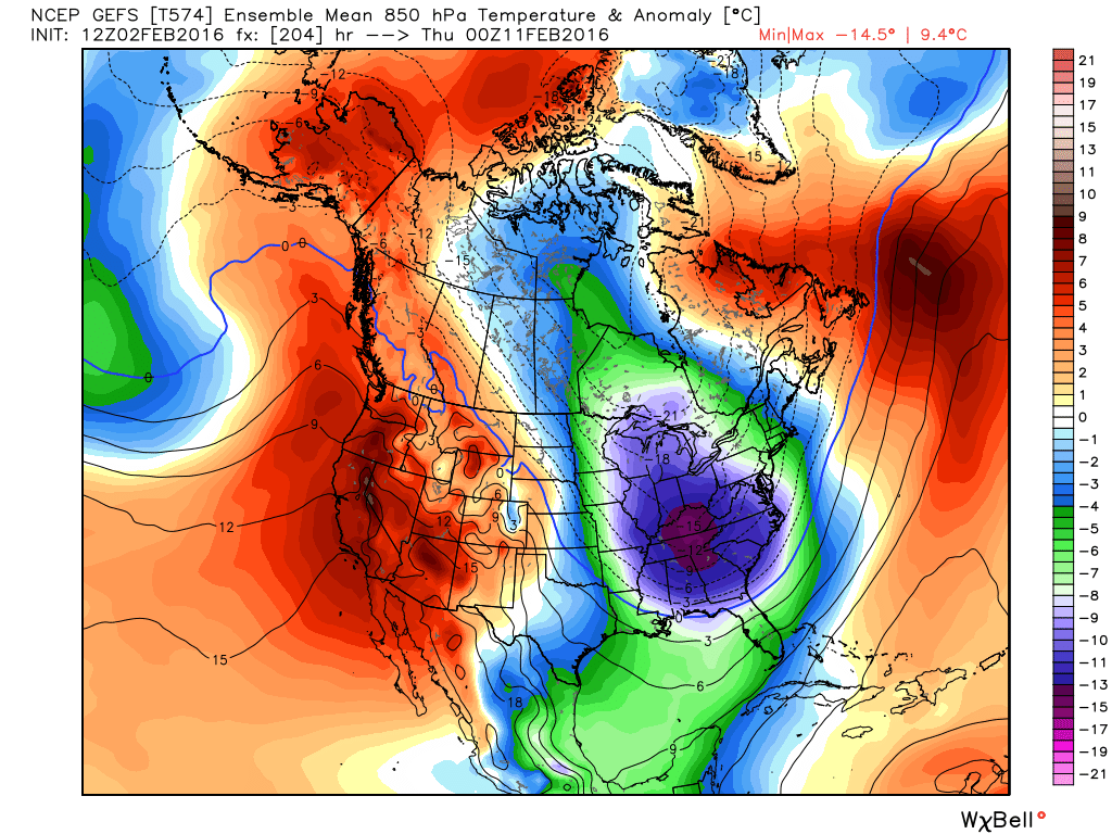
A cross-polar flow develops next week, bringing some harsh cold down out of the arctic. Source: Weatherbell
So will it change? Yes, yes it will. We get a small cool-down for Friday, but the larger outbreak of arctic air is on track for next week. All signs have been pointing to the main push of this frigid cold to take place across the Midwest and Southeast to start...and then to have it slither on over to New England by mid to late week. We may finally put together a solid stretch of truly cold temperatures running below average through the middle of the month, at least. Those types of stretches have been few and far between - the days at or above average and besting the ones below average at a rate of 5:1 since November 1st.
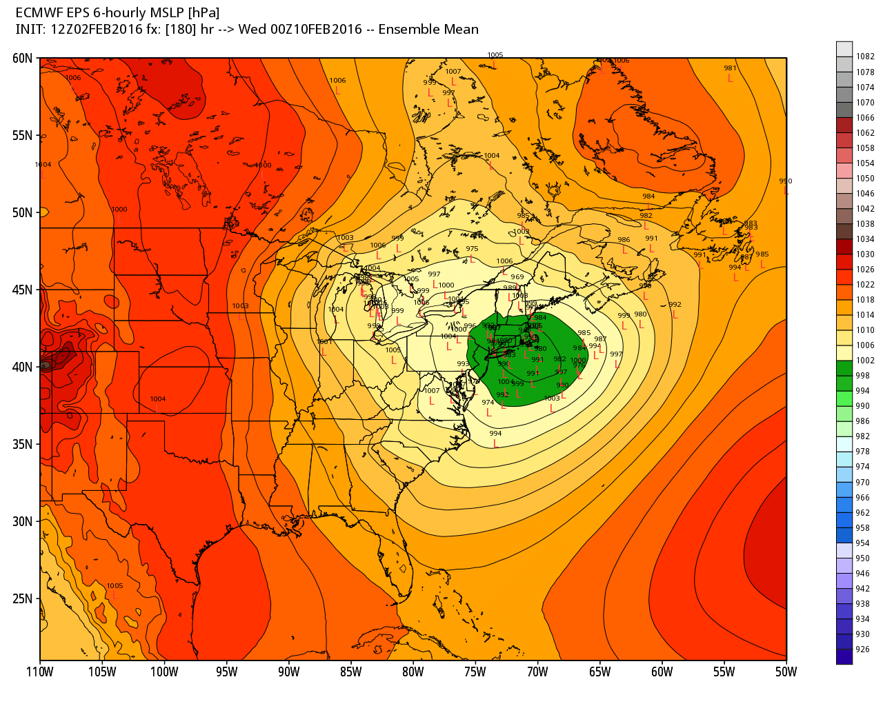
ECMWF EPS low locations early next week. There is still a large spread, but here is hope for snow lovers in New England. It's the next 'interesting' period to watch. Source: Weatherbell
Will it come with snow? I'd say that chances are looking pretty decent. The period to watch is Monday through Wednesday, the 8th through 10th. There may end up being two impulses to track which form along the leading edge of all this arctic air. There is still a wide spread amongst model guidance on where/when the storm will move, but there will very likely be activity along the East Coast during this time. It may end up that this is another inside track storm that hugs the coast, but I'm finally a little optimistic for interior New England. In particular, ski country, which could desperately use a snowstorm before President's Day and vacation week. We'll keep tabs on this setup and details should become more clear as we head toward the end of this week.
Now chances look somewhat promising next week, but the window may not stay open for too long. A couple more clipper systems are showing up in the guidance late in the week and toward Valentine's weekend, so the overall pattern appears active. After that though, the cold may shut back down. By the 17-20th a warmer setup may regain control and take back the reins. So we'll have to see what we can squeeze out the 8th through 18th or so. To me, it looks one of the best chances New England has had so far this winter. Fingers crossed.
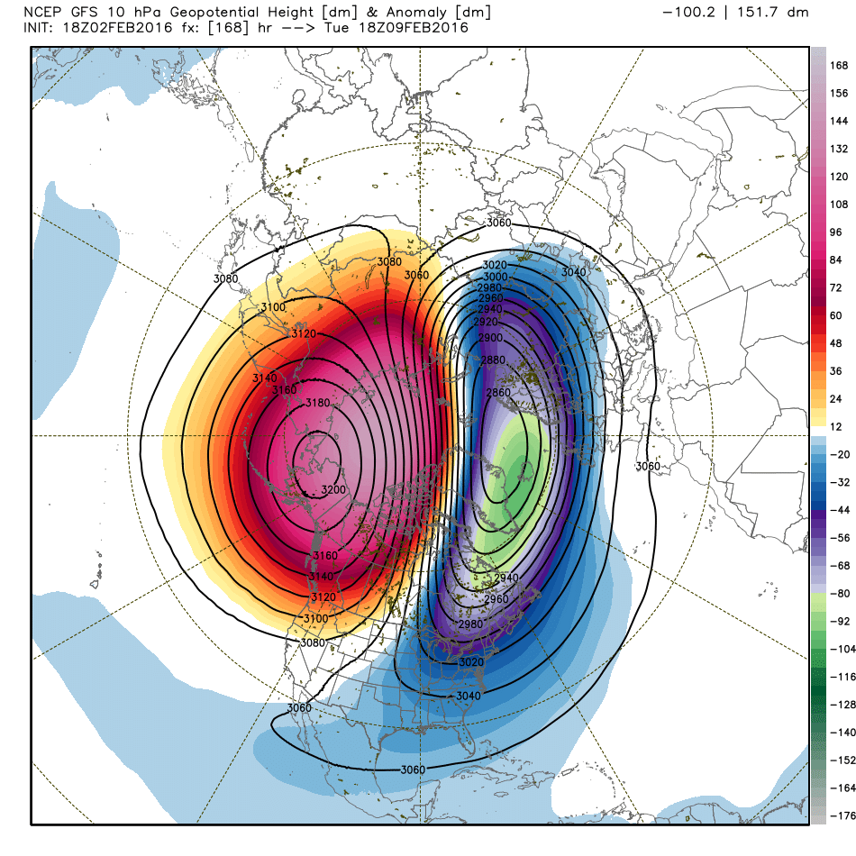
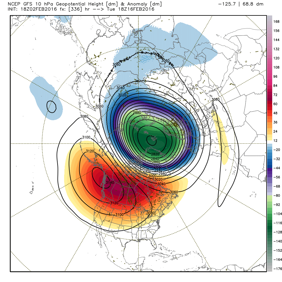
The GFS has been calling for a displaced/weakened polar vortex next week, allowing for an intrusion of arctic air. However, it also expects the PV to reorganize around the pole later in the month and strengthen, which could draw the cold back up to the north and allow a return to Pacific air across the Lower 48. Source: Weatherbell
The wildcard in all of this is a sudden stratospheric warming event and its impact on the polar vortex. As you may recall, the PV is a river of fast moving air that wraps the pole and oscillates in strength. When we get a SSW (where the air in the stratosphere, in the vicinity of 10mb, warms rapidly), it puts pressure on the PV and can weaken the flow or displace/stretch the PV. In a strong SSW, the westerlies at high altitudes slow down or even reverse, becoming easterlies. That in turn can shut down the train of jet stream disturbances, and allow high pressure to force cold air out of the arctic. That's why there's been so much focus on the PV in recent years when we've had big cold across eastern North America.
However, there are opposing forces in this case. To get an insanely cold winter like the last two, you need a lot of things to go 'right' (I'm sure most of you would argue 'wrong'). Looking at the rest of this month, the opposing forces are El Nino and the MJO (Madden-Julian Oscillation). El Nino adds a wrench because it offers an amped subtropical jet stream and a flood of mild Pacific air into the Lower 48. The MJO has been and is expected to be in phases 4-5 for the next couple of weeks, which favors a trough over the western U.S. and ridging over the central and eastern U.S. The bottom line is that you have two forces competing against one, not all of them working in concert to really allow for a long period of serious cold.
So the mild party ends after this weekend and a much colder week should follow and last into the start of the following week, but I wouldn't bank on that cold holding strong throughout the rest of the month. We may get back into a mild pattern heading toward the back half of February. We'll see how all these things play out over the next several weeks but in the meantime for winter lovers, I'd put a good portion of your eggs in next week's basket.
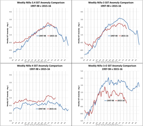
On a final note, how's El Nino doing? Well it continues to weaken as we head into the home stretch of winter, especially in regions 1+2 right off the coast of South America. But it remains a formidable event. The largest anomalies are west of the typical El Nino 1+2 regions and are actually increasing farthest to the west. Typically in a strong El Nino winter, the wettest stretch of the event sets up for California. It does not appear this will be the case in 2016. Much of February is looking very dry, as a matter of fact, for California. Which is not great news considering they have not done much to dent the drought. Basically it's just been a slightly wetter than average winter so far, and they could use a whole lot more. South of the Bay area there's literally no rain or snow in the forecast through mid-February. El Nino itself is expected to fade and switch to the La Nina phase later this year, which may put us back in play for a busy winter in 2016-17.
Source: Jan Null


