Forget Phil - Your February Outlook
Oh, the joy of pulling a rodent out of the ground at daybreak to figure out the future!
The time is almost upon us, where groundhogs across the nation are thrust into the spotlight as we anxiously await news of whether we should book tickets to the nearest tropical location. It's all in good fun, and I must admit I love hokey traditions. Winter is long, community events are enjoyable, and now that football is just about finished we need something to fill the time. All excellent. But the scary part is that many people actually believe these prognostications. Don't laugh, it's true. It's the same crowd that ardently believes in Farmer's Almanac outlooks. Whoops! No hard feelings for the F.A. - I buy it every year and enjoy the read. It's good entertainment. I encourage you to do the same. But the track record...
Juuuuuuuust a bit outside.
So should you believe that shady local meteorologist? With the untrustworthy science and technology? I'd say you could do worse. I hope so, anyway! So far the winter outlook is right on track, and here are some thoughts on the final month of Meteorological Winter (Dec/Jan/Feb) and for those who don't believe in meteorological seasons, a look into March as well.
![]()
Rankings for December/January combo across the Northeast. Nearly every site is in the Top 3 with a couple mild days to go. Source: Southeast Regional Climate Center
For starters, let's start with the slam dunk. This winter will go down as warmer than average, and there's nothing Mother Nature can do to stop it. December was absolutely exceptional, running +10.6º versus average and crushing records in the process. January wasn't extreme, but it was no slouch. We'll finish about +3º versus average and most of New England will see its warmest December/January combo on record. Even if we had a February WORSE than last year (the coldest month on record for most of New England), it still wouldn't be enough to make winter below average. And considering the start, there's no shot. None.
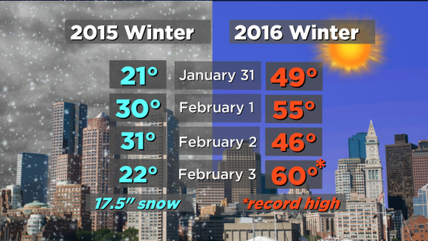
That start includes a pattern reminiscent of December for the east. A zonal flow kicks things off for this weekend into Monday, and that keeps the cold out of here. February 1st will feature 50s around the area, a solid 20 degrees above the norm. That's just the start, as a major storm system winds up in the Plains and heads to the Great Lakes. Since it's a cutter, we'll be on the mild side of this one just like the pre-Christmas storm. Deep southerly winds will bring rain all the way up into Canada, and highs here should be in the 40s to near 50F on Tuesday and make a run at 60F on Wednesday. Considering the slow movement of the front, we'll probably get a midnight high on Thursday that will be somewhere near 50F. So when you put that all together, the first five days of the month will probably be running +12F versus average. That's 17% of the month so strongly above average that it's going to take quite a few major cold shots to overcome an above average month overall. Winter's has it work cut out for itself.
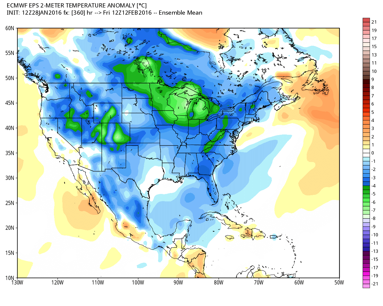
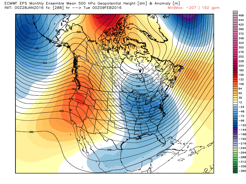
ECMWF EPS mean temp departures show cold really making some inroads by the middle of the month. I think the core of this will likely end up being focused just to our west. Source: Weatherbell
However, that warm air is not here to stay, and there are some interesting players on the field for the rest of the month. The first major cold blast will be focused on the Plains, Midwest, and Southeast behind that departing 'warm storm.' As we head into next weekend, that air mass will arrive here in modified form. That means it'll certainly feel like winter again, but I don't expect it to be terribly harsh. Just a return to normal.
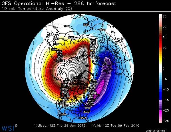
Major stratospheric warming is being forecast in early February, displacing/stretching the polar vortex and perhaps even splitting it. Source: WSI Energycast
At the same time, many are focusing on a strong sudden stratospheric warming (SSW) event that's getting underway. This happens when there is a flux of energy in the vertical pushing up into the atmosphere. The stratosphere warms, and puts pressure on the polar vortex. In some SSWs, the polar vortex can weaken to the point of splitting. This is all happening many thousands of feet above our heads, in a layer of the atmosphere that usually is not a part of our weather (of which most happens in the troposphere). So why does it matter? Well a weakened polar vortex ends up producing an erratic jet stream, allowing some of the harsh cold that's been bottled up in high latitudes to move equatorward. A displaced or stretched PV can also leave strong high pressure over the high latitudes, which in turn gives us a -AO (arctic oscillation) and opens the door to cold air. We saw a whole heaping pile of this over the past two winters, with the jet stream taking on deep undulations with record warmth in some areas (like the western U.S.) and extreme cold in others (the eastern U.S.).
Here's the tricky part - not all SSWs are the same, and there is a limited number of documented events. We don't have a full sample of SSWs in different ENSO (El Nino Southern Oscillation) phases, different MJO (Madden-Julian Oscillation) phases, etc. So it can be difficult to say exactly what the outcome will be. Just because there is a SSW event doesn't mean the eastern U.S. will automatically freeze.
What we do know is that the main impact of a SSW event at the lower-levels is often a couple of weeks following its peak. This places us on watch for mid to late February into early March. The first cold shot for us arrives next weekend, and I think it will be transient (not persistent). But looking toward late month, the cold may settle in and stick around into March. That means an early spring or an extremely mild stretch (such as what we saw in 2012) is looking very unlikely. Winter isn't leaving us yet.
High impact Northeast storms by week. Mid-February is an infamous time of year for major storms. Source: Tom Niziol
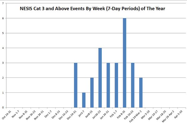
This also coincides with what is our more notorious stretch for winter storms. The highest concentration of big Northeast storms is early February through the start of March. So colder air will be matching up with a climatologically busy time for storms. Lo and behold, check out the latest ECMWF weeklies. That my friends is a pretty good pattern for an eastern U.S. winter storm. We have a strongly +PNA (ridging over western North America) and a deep trough digging into the east. There isn't a ton of blocking, but there's enough. All told, don't put away the shovels yet.
CONCLUSIONS:
February 1-5th will feature a very warm start with well above average temperatures, a rainstorm, and maybe even some record highs on Wednesday. This will kick off the month with a strong base above average.
February 6th-8th is a transition time with colder air getting established and a return to a wintry feel.
February 9th - 16th is a time frame I'd target for a possible storm system (or two) to move in. It appears we'll have enough cold to work with and it will just come down to timing of disturbances and whether or not they're on the scene to tap that cold.
February 17th-29th should keep life interesting. Right now I'd lean colder than average but not as persistent/deep as what we saw last year. All told, this will not be enough to give us a month of below average temps as a whole. I think we end up +1 to +2.5F versus an average February, and end up with a Top 20 warmest winter on record in southern New England.
March - An unlikely rush into spring, with cold lingering into at least the start of the month. We're not 'in the clear' for winter storms until well into early April (read: April Fool's blizzard in 1997) so there should be more snowy opportunities in March before we start to say goodbye to winter weather.