Southeastern Mass. Getting Battered By Blizzard Conditions
BOSTON (CBS) -- FEET of snow have fallen already in Washington D.C., Baltimore, Philadelphia and New York City. . . INSANE. These cities are essentially getting a season's-worth or more of snowfall in one "foul" swoop. And Saturday night, it was our turn.
Thankfully Boston is just a bit too far north to get in on the heaviest snowfall, but our South Coast, Cape Cod and the Islands are getting battered by blizzard conditions.
Check Current Conditions | Download Weather App
Here is what to expect
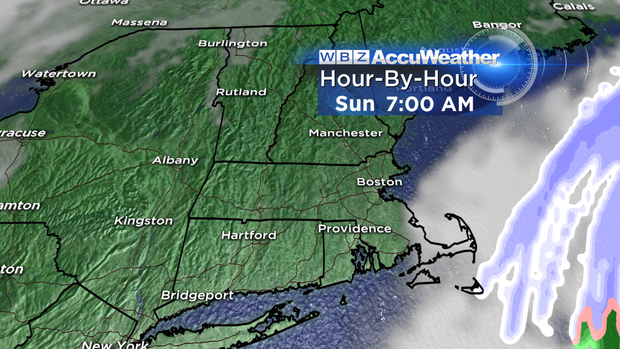
After midnight: The storm begins to pull east and the snow retreats from northwest to southeast. Any snow accumulation will be just about done in Boston and points north. The back edge of steady, accumulating snow will progress from Boston around midnight to the Cape Cod Canal by 5 a.m. Snow rates will becomes lighter, however winds will still be howling, gusting over 50 mph at the coastline.
Sunday morning, after dawn: When you wake up in the morning, it is long gone. There could be some lingering light snow or flurries over Cape Cod and Nantucket, but otherwise stick a fork in the Blizzard of 2016. Winds will veer to the north and northwest behind the storm and remain gusty, 25-45 mph.
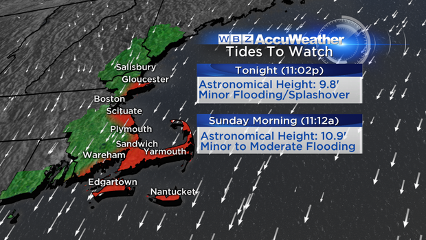
There will likely be some minor coastal flooding between 10 a.m. and 2 p.m. Sunday along the South Shore and Cape (NNE facing beaches).
How Much?
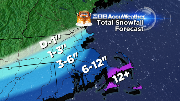
Dusting to an inch: 495 belt north and west of Boston including Westford, Lowell, Lawrence and Haverhill.
1-3": Between 495 and 128 north and west of Boston including Billerica, Wilmington, Andover and Worcester.
3-6": City of Boston to Providence including most of Norfolk county and immediate North Shore to Cape Ann.
6-12" or more: South shore from Scituate to Plymouth, all of Plymouth and Bristol Counties, Cape Cod and Islands. There is a chance that parts of the Cape and Islands could reach as high as 12-18" thanks to locally heavy, intense snow bands, dropping 3" per hour.
The gradient with this storm was simply incredible. With snowfall totals ranging from nothing to as much as 18" in a range of just 50-100 miles, you can see why forecasts this week were a bit up and down. Being on the fringe of a historic blizzard has it hazards!
Come Sunday afternoon, we can put this one behind us and focus on getting to another Super Bowl. The forecast in Denver: mainly cloudy, near 40 and dropping with a chance of snow showers and of course a big Pats victory!
Follow Terry on Twitter @TerryWBZ


