Snow Storm's Track Down To Wire For Southern New England
By Terry Eliasen, Meteorologist, WBZ-TV Exec. Weather Producer
BOSTON (CBS) - Here we go. One of the largest East Coast winter storms in recent memory is underway. In a word, this storm is MASSIVE.
At this hour, it stretches more than 1,000 miles in each direction - from Columbus, Ohio to Havana, Cuba and from Little Rock, Arkansas to the Outer Banks of North Carolina. Moderate to heavy snow is already falling in Jackson, Mississippi, Little Rock, Arkansas, Nashville, Tennessee, Louisville, Kentucky and Roanoke, Virginia.
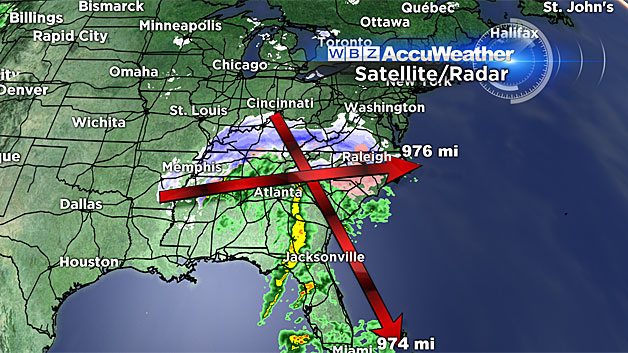
An ice storm is underway in parts of the Carolinas.
Strong thunderstorms are rocking parts of Georgia and Florida.
And we're just getting warmed up.
They haven't even gotten started in the Mid-Atlantic yet, but blizzard warnings are posted from Washington D.C. to Long Island, New York. A whopping 23 states are currently under some sort of winter storm watch or warning associated with this one storm. Over the next 48 hours, an enormous portion of the eastern United States is going to get buried in white.
An entire landscape, transformed by one blockbuster atmospheric event.
The "jackpot" area has not changed since yesterday. Upwards of 2 feet of snow is still expected in parts of northern Virginia, West Virginia, Maryland and Pennsylvania, including Baltimore and Washington, DC.
Just for a little perspective, they average a little over a foot of snow per SEASON in Washington. Only once in recorded history (way back in 1922) has our nation's capital received 2 feet or more in a single storm. To say this storm will be historic is an understatement.
WE'RE ON THE EDGE
Closer to home we are still "livin' on the edge."
If this storm were a giant pizza, we would be getting the crust here in southern New England.
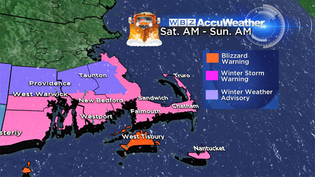
A Blizzard Warning has been issued for Martha's Vineyard. A Winter Storm Warning has been issued for the South Shore, South Coast and Cape Cod.
Trying to forecast what will happen on the northern-most 100 miles or so of this 1,000 mile+ wide storm is no easy task. Not to mention, there will be a significant cutoff line between those who see a lot of snow and those who get shut out. And we are living right in that transition zone.
Having said that, we are going to be sweating this one right down to the wire.
One thing is for sure, the farther south you live in southern New England, the greater chance you have of getting in on the action.
The reverse is also true, those north of Boston, have very little chance of any significant snow accumulation.
So let's dig in to the nitty gritty details.
TIMELINE:
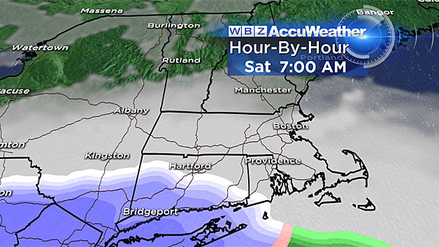
Saturday 7 a.m: Snow will have overspread New York City and will be headed into Southern Connecticut…otherwise quiet in New England.
Saturday 1 p.m: Steady snow likely from Hartford to Providence and making northward progress into southeastern Massachusetts. Flurries possible as far north as the Mass Pike.
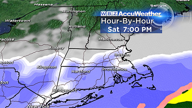
Saturday 7 p.m: Steady snow south of the Mass Pike, heaviest south on a line from Providence to Plymouth and areas south. Flurries/light snow possible up to MA/NH border.
Sunday 1 a.m: Again, steadiest and heaviest snow remains in southeast MA including southern Plymouth and Bristol counties and all of Cape Cod and the Islands…Flurries/light snow still possible as far north as MA/NH border…With winds peaking overnight and the steadiest snow coming during this time, there could be near whiteout conditions over extreme southeast MA.
Sunday 7 a.m: Storm pulling east…steadiest snow now over the Outer Cape and Nantucket. Light snow/flurries possible in eastern MA, but tapering quick from west to east.
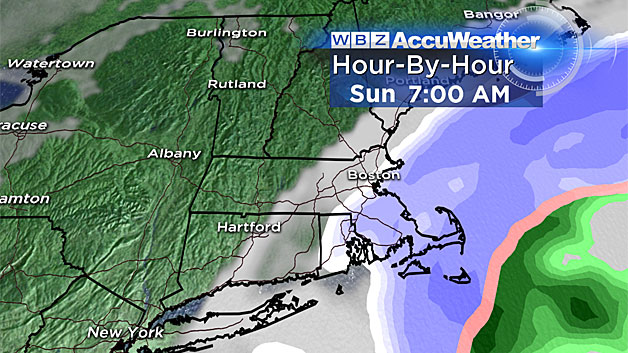
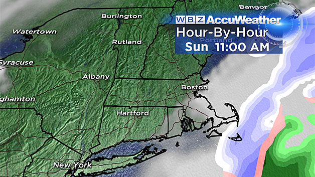
Sunday Late Morning/Midday: See ya…few leftover flurries on the Outer Cape, otherwise long gone.
HOW MUCH?
Gotta couch this with the idea that a slight wobble in track (just 50-to-100 miles) and these totals could increase or decrease as much as 3-to-6 inches very easily.
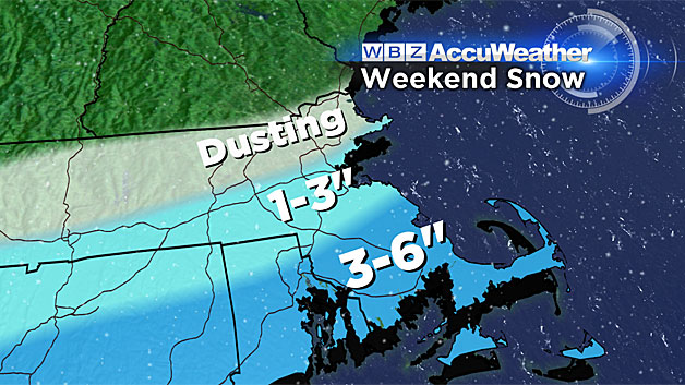
6 inches (or more):
Extreme South Coast, lower Cape and Islands (including New Bedford, Falmouth, Vineyard, Nantucket).
3-to-6 inches:
South Boston to Providence to Hartford and points south including most of inland southeastern Mass. and coastal Plymouth County.
1-to-3 inches:
Mass Pike area from downtown Boston to Worcester and a few miles either side (north and south).
Coating to an inch:
All areas north of the Pike, up to MA/NH border.
Nothing:
New Hampshire, Vermont, Maine
WINDS:
Despite the storm being a good distance offshore, we will likely experience some damaging winds. The most vulnerable locations in southern New England would be areas of extreme southeastern Massachusetts including Cape Cod and the Islands.
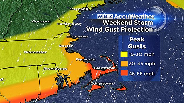
Wind gusts in this region on Saturday night and early Sunday morning could peak over 50 mph, perhaps briefly as high as 60 mph. For the remainder of coastal Mass., including Boston and the North and South Shores, wind gusts could be a strong as 40 mph early Sunday morning.
If the 50-60 mph materialize over southeastern Mass., some isolated power outages and pockets of wind damage would likely occur.
TIDES:
With a full moon this weekend, tides are astronomically high. Therefore, it won't take much to get some minor coastal flooding with this event.
First tide of concern occurs around 11 p.m. Saturday and there is some risk of minor flooding and splash over in extreme southeast Mass. at that time.
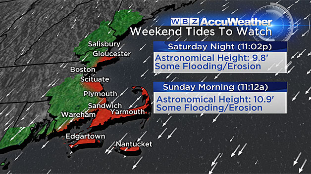
The greatest concern lies with the Sunday morning high tide just after 11 a.m. particularly in coastal Plymouth County and over the Cape and Islands. Seas just offshore in that area will be as high as 15-to-20 feet and a 1.5-2.5 foot storm surge is predicted. This would undoubtedly produce widespread minor coastal flooding with a risk for pockets of moderate flooding.
As with so many New England storms over the past several years, beach erosion will once again be an issue. Primary area of concern would be bayside Cape beaches from Sandwich to Dennis as well as the outer Cape and Nantucket beaches.
As always, we will be providing frequent updates to this forecast on WBZ-TV, WBZ NewsRadio 1030 and CBSBoston.com. Whenever we get updated information we will pass it along to you. Any slight shift in track will have very large consequences for our area.
Follow Terry on Twitter @TerryWBZ