Southern New England On Edge Of Massive East Coast Snow Storm
By Terry Eliasen, Meteorologist, WBZ-TV Exec. Weather Producer
BOSTON (CBS) -- Living on the edge--that's about the best way to summarize our current forecast for this weekend.
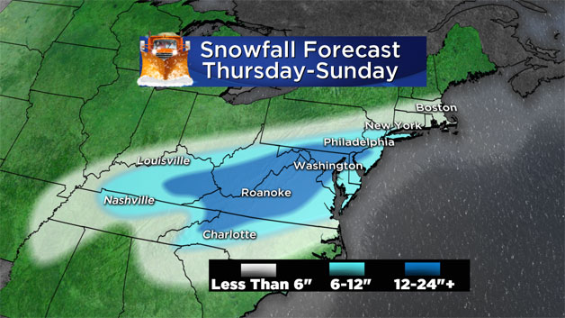
A massive East Coast storm is beginning to take shape in the deep South. Residents from Charlotte, North Carolina to Roanoke, Virginia to Washington, DC are preparing for more than a foot of snow, many for more than 2 feet.
Amazingly though, here in Boston, last winter's snow capital of the world, it's becoming increasingly likely that we may be spared this go-around.
This one's going to be a nail-biter for all of those on the northern fringe of this storm, and unfortunately, that includes New York City and areas in extreme Southern New England. There will be an very sharp cut off between those digging out from a foot or more of snow and those who literally won't even see a flake.
These are the kind of winter storms that keep meteorologists up all night. At its peak, the storm will grow to be a monster, nearly 1,000 miles wide and in the end, the difference between southern New England getting a minor accumulation and a major snow event will be as little as 50-to-100 miles.
There is a clear forecast trend today, and that is to push the snowfall totals farther south. Should that trend continue, the snowfall from this storm in our area would range from a very minor accumulation to none at all.
Having said all that, let's try to break this thing down as best we can hour-by-hour and inch-by-inch.
TIMELINE:
Saturday morning, 7 a.m: Snowing like crazy in Washington, D.C. and Philadelphia, with the heavy snow on the doorstep to New York City. All is quiet here.
Saturday Noon: Snow continues in the Mid-Atlantic and New York City region. Some light snow or flurries may reach as far north as Hartford, Providence, and our extreme South Coast.
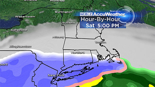
Saturday 5 p.m: Steady snow from New York City to Nantucket, lighter snow and flurries from Hartford to Providence to our South Shore. Small chance of a few flakes as far north as the Mass Pike.
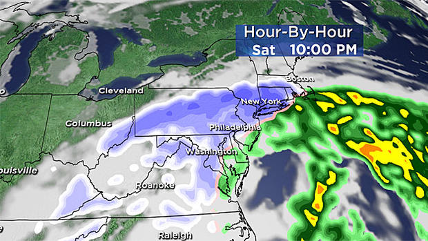
Saturday 10 p.m: Steady light snow from Providence to Plymouth and areas south. Some light snow/flurries up to Worcester and Boston and nearby 'burbs.
Overnight through dawn Sunday: Storm already pulling east and bringing the snow with it. Light snow possible from the Boston area to Providence and points southeast.
Sunday after dawn: Snow tapering off in southeast Massachusetts--it's all over.
AMOUNTS:
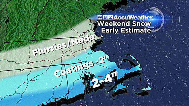
Highest totals: up to 2-4" in extreme southeast Mass., southern Plymouth and Bristol Counties, Cape Cod and the Islands. This snow forecast could increase or decrease by a few inches with a slight wobble in storm track.
(WBZ graphic)
Mass Pike area from Worcester to Boston south to Providence/Plymouth line: Not much. Scattered coatings to as much as 2". I wouldn't be surprised if this area got no accumulation.
North of the Mass Pike up to Mass./N.H. border: You'll have to really look hard to find any flakes up here--no accumulation expected.
WINDS:
Despite the storm being a good distance offshore, we will likely still experience some damaging winds. The most vulnerable locations in southern New England would be areas of extreme southeastern Massachusetts including Cape Cod and the Islands. Wind gusts in this region on Saturday night and early Sunday morning could peak over 50 mph, perhaps briefly as high as 60 mph hour.
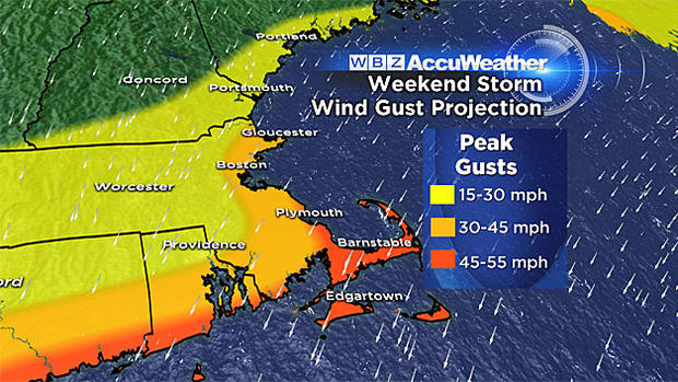
For the remainder of coastal Mass., including Boston and the North and South Shores, wind gusts could be a strong as 20-to-40 mph early Sunday morning. If the 50-60 mph winds materialize over southeastern Mass., some isolated power outages and pockets of wind damage will likely occur.
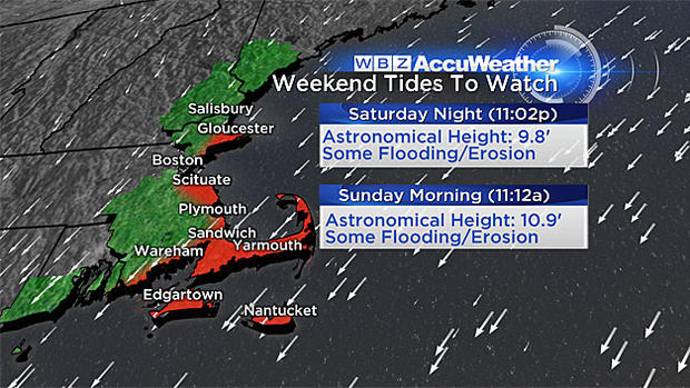
TIDES:
With a full moon this weekend, tides are astronomically high. Therefore, it won't take much to get some minor coastal flooding with this event.
The first tide of concern occurs around 11 p.m. Saturday. There is some risk of minor flooding and splash over in extreme southeast Massachusetts at that time. The greatest concern lies with the Sunday morning high tide just after 11 a.m., particularly in coastal Plymouth County and over the Cape and Islands. Seas just offshore in that area will be as high as 15-to-20 feet and a 2-to-3 foot storm surge is predicted. This would undoubtedly produce widespread minor coastal flooding with some pockets of moderate flooding.
As with so many New England storms over the past several years, beach erosion will once again be an issue. Primary areas of concern would be bayside Cape beaches from Sandwich to Dennis, as well as the outer Cape and Nantucket beaches.
As always, we will be providing frequent updates to this forecast on WBZ-TV, WBZ NewsRadio 1030, and CBSBoston.com.
Watch: Terry and Danielle Niles with the latest on the storm
Whenever we get updated information, we will pass it along to you. Despite the current forecast for a "fringe" here, this storm should not be taken lightly. Any slight shift in track would have very large consequences for our area.
Follow Terry on Twitter @TerryWBZ