Weekend Nor'easter - Trends and Talking Points
BOSTON (CBS) - There's one thing I'm guilty of and from what I can tell, just about every meteorologist is guilty of. You see we're all geeks, and we often stick together. We talk about weather, we share computer models, we discuss setups. It's our life and it's a very small circle so far as career paths go. And to hang around in that crowd, there's a certain lingo that generates blank stares from most normal people. We may as well be speaking Sanskrit half the time.
So I thought for the start of this post I'd put together a few acronyms and terms to get you through the dark winter days, and to help decipher some of the geek speak you may see on the blog or during Twitter conversations. My belief has always been to try and share our science, instead of trying to dumb it down too much. So without further ado...let's get weird.
Z - Ever see us use '12z' or '00z' in discussing models? Z stands for Zulu, as in Zulu Time (or Greenwich Mean Time). All computer models and weather balloon launches operate on GMT, so that it's coordinated around the world. We're 5 hours behind GMT during standard time, and 4 hours behind during daylight saving time. So 12z right now = 7am. 00z = 7pm, and so on.
ECMWF - European Centre for Medium Range Weather Forecasts. This is the home of the 'Euro' model you so often hear about. It is widely regarded as the best computer model out there for medium range forecasting, runs twice a day, and has an excellent track record. But user beware - we have a saying in weather 'All models are wrong, some are useful.' No guidance is right every time.
EPS - Ensemble Prediction System. This is the ensemble forecasting group of the ECMWF. Essentially, you take the initial ECMWF, perturb or change some of its initial conditions/variables, and run it dozens of times. When EPS members are in great agreement, our confidence grows. It means that no matter what we're doing to change a setup, the outcome is similar. This runs twice a day.
GFS - Global Forecast System. This is the U.S. version of a global forecast model. The GFS runs 4 times a day, every 6 hours.
GEFS - Global Ensemble Forecast System - The GEFS is to the GFS as the EPS is to the ECMWF. We get a set of GEFS guidance every time the GFS runs (4 times a day, every 6 hours).
NAM - North American Model. We often nickname this one the "SCAM" because it's not very reliable. But it can be useful in heavy precipitation events in particular. This model also runs 4 times a day, every 6 hours.
GEM - Global Environmental Multiscale Model - this is Canada's version of the GFS/ECMWF. It runs twice a day.
SREF - Short Range Ensemble Forecast. Another model that we use mostly for mesoscale weather (thunderstorms, localized events, etc). It is available at 3h intervals through 87 hours.
HRRR - High Resolution Rapid Refresh Model - we use this one only for short time scales, under 16 hours. It's higher resolution and runs every hour.
RPM - Rapid Precision Model. This is the one you see on TV every day. It's produced and operated by WSI, Weather Services International, which is located in Andover, MA. If you're watching weather on TV, chances are WSI created the software to make those graphics.
Bombogenesis - A rapid fall in pressure as a storm develops. To be a 'meteorological bomb' a storm must have its pressure drop at least 24 millibars in 24 hours. There's a direct relationship between how low pressure goes and how strong winds become (lower pressure = stronger winds).
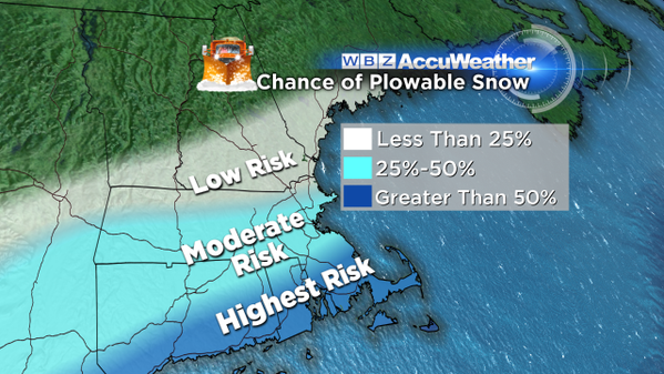
Plowable Snow - Typically when we say this, we're talking about at least 2" of snow. That's what many plow operators use as the minimum amount of snow to go take care of their clients.
Significant Snow - Often referring to totals over 6"
Evaporative Cooling - This is the process during which falling rain/snow falls into dry air and evaporates. It often occurs when a storm is moving in and we have a dry air mass (low dew points) in place out ahead of it. When water or ice evaporates in air, it removes energy from its surrounding environment. Lots of evaporating drops/flakes can help cool air down until it saturates.
Blizzard - This term probably gets thrown around far too often, because you have to meet a very specific criteria for an actual blizzard. It's based off of visibility and wind, which also means it has nothing to do with how much snow falls. They have 'ground blizzards' all the time in the Plains with no snow falling at all. To be a true blizzard, visibility must be less than 1/4 mile with winds consistently gusting over 35mph for a minimum of 3 consecutive hours.
Divergence/Convergence - These are things we look for when seeking out areas of rising or sinking air. Divergence is where air is leaving the column, and convergence is where it's coming together. We look for strong divergence aloft and convergence at the surface when figuring out where precipitation will fall heavily.
Well anyhoo, that's at least a few. Send me a tweet @ericfisher if there are some terms you'd like added to the list!
So how about the storm? My previous post is here and I haven't seen a whole lot of change in the past 24 hours. There's been a subtle shift to the south amongst model guidance, but I think the main ideas are the same.
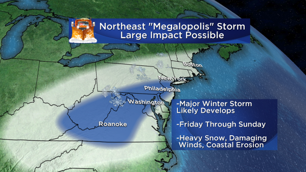
- A major East Coast snowstorm is still very likely. In fact, nearly guaranteed for the Mid-Atlantic. The energy for this storm has come ashore along the West Coast, and will make a cross country trip this week. There is excellent agreement that a massive snowstorm will take shape in the Mid-Atlantic region, with a storm really ramping up right off the coast of the Virginia Beach area. The hardest hit states look like Virginia, Maryland, Pennsylvania, Delaware, New Jersey, West Virginia, and possibly eastern Kentucky. Widespread 1-2 foot totals look quite possible, and perhaps some up to 3 feet in this belt. The bigger questions arise once you head north of Long Island.
2. Southern New England is on the edge. That's what makes the call here so tricky. I think there's going to be a VERY sharp gradient between big snow totals, and nothing at all. So our job the next 24-48 hours is to figure out where to draw that line. As it stands now, bigger snow >6" would be favored more toward the South Coast/Cape/Islands/South Shore. Confidence is decent for plowable snow in the Boston area/along the Pike, but the cut-off north of that looks very sharp. There's a good chance New Hampshire gets little or nothing at all, and the same goes for Vermont and Maine. This looks like a non-event for northern New England thanks to a big dome of cold and dry high pressure.
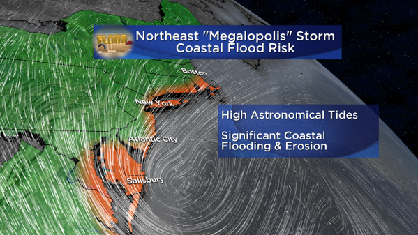
3. Coastal Flooding is a concern - A full moon would fill the night sky Saturday, if we weren't going to be overcast. That means astronomical tides are already running high. Bring in a strong onshore flow, and we could have some serious issues with coastal flooding and erosion. If the storm trends a little farther north, this problem would increase for us. So anyone along the shoreline should closely monitor the progress of this storm. The worst conditions right now are expected to be from coastal Maryland to Long Island Sound...and perhaps reaching up this way too.
4. Don't re-arrange all your plans yet. I'm writing this on Tuesday evening, which is about 4 days away from the start of any snow. Nothing in a forecast this far out is set in stone and locked in. I would wait until at least Wednesday evening, if not Thursday morning, before making any choices about canceling plans, dinners, trips, flights, etc. We live in a frustrating time when identifying patterns that are good for storms happens a long way in advance, but the exact details still can't be worked out until 2-3 days in advance. It stinks and hopefully science gets there someday, but I fully expect us to be a lot more confident of the outcome by Wednesday afternoon. Then we'll decide if we need to move from the 'aware' phase to the 'action' phase.