Examining Chances For Big Weekend Snowstorm
By Terry Eliasen, Meteorologist, WBZ-TV Exec. Weather Producer
BOSTON (CBS) - "Is it gonna be a blockbustah?" "Are we gonna get a nor'eastah?"
The inquiries are flooding into the weather office, it seems nothing gets the juices flowing this time of year more than some good ol' fashion winter storm conjecture.
And unfortunately, that is exactly what this blog essentially is at this point - conjecture. There is a big difference, in my mind, between storm "hype" and an educated discussion, so let's hope I can deliver the latter in the next few paragraphs.
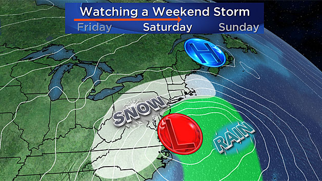
By now you certainly have heard the news, there is potential for a large and significant East Coast storm later this week and over the weekend. I wish I could break it down hour-by-hour here for you but it is simply too early to do so.
Right now, as we speak, the "energy" for this storm (what makes it tick) is located a few hundred miles west of Portland, Oregon, out over the open Pacific Ocean. This poses a bit of a problem for our trusty computer models because we just aren't able to get a good sampling of the atmosphere out there. Satellites and aircraft can give us some limited information, but until it comes ashore Tuesday night over Oregon and northern California, we really won't have a complete picture and set of data to work off of.
Therefore, we are in a bit of a "wait and see" mode for the next 12-to-24 hours. Anyone claiming they have the final answers on a storm system this complex and this far out in time just is selling you damaged goods.
There are some things we can be certain of as of this writing:
First and foremost, there WILL be a significant East Coast storm.
This thing isn't going to just fizzle out and turn to dust. The packet of energy I spoke of earlier over the Pacific Ocean is going to dig into the deep south and get a shot in the arm from the warm and moist Gulf of Mexico by Thursday evening. During the day on Friday, soaking rains will fall in the southeastern United States, while heavy, wet snow will blanket the lower Ohio Valley and Appalachians.
From there I think we can also say with a good degree of certainty that this is going to be a big blow for the mid-Atlantic region. This is as close to a "slam dunk" as you can get this far out for the region stretching from Norfolk, Virginia to Washington D.C. to Philadelphia and Atlantic City. There just aren't many scenarios by which those areas get anything less than a foot of snow.
In fact, I think 2 feet of snow is a real possibility in parts of northern Virginia and Maryland.
WE COULD BE SPARED THE WORST
After that, this picture gets a little more "cloudy."
Some of our more trusted models are depicting a scenario by which southern New England would be spared from the worst of the storm. With a bit more of a digging Jet Stream, the storm track would stay far enough to our south so that we would only be fringed by the northern shield of snow and wind.
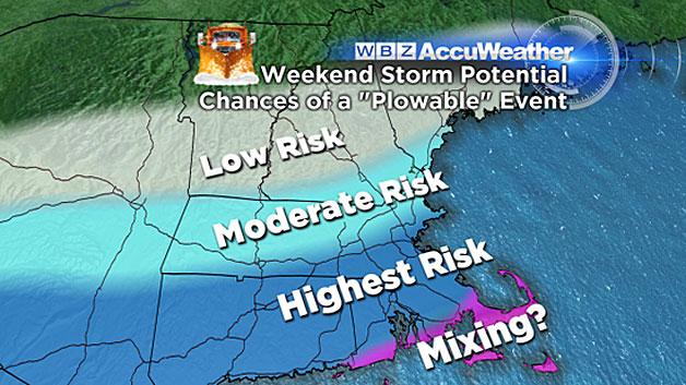
Under this scenario, the heaviest snowfall would be in extreme southern New England. In fact, there would be very little if any snow in parts of central and northern New England.
The highest amounts would like range from 6-to-12 inches, still a formidable event, but nothing close to a worst case scenario.
WORST CASE SCENARIO
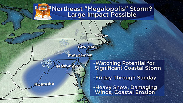
Speaking of which, we cannot yet rule out a direct hit here in southern New England.
I would rate this at no higher than 40-percent right now, slightly favoring the farther south solution. But, if the northernmost track were to occur, we would be in for a full-fledged, raging nor'easter here over the weekend - complete with 1-2 feet of snow, ferocious winds, (likely well over 50 mph at the coastline), and serious coastal flooding over several high tide cycles.
It is because of this solution that the stakes are extremely high with this event.
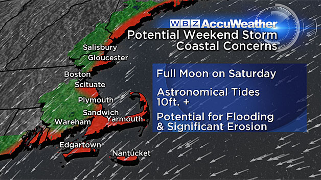
This would be a slow moving, plodding, storm system. Arriving sometime in the morning or midday on Saturday, we wouldn't be totally free of the wind and snow until later on Sunday. Combine the strong and persistent northeast winds with a full moon and high astronomical tides and we could be in for yet another devastating blow to our coastline.
A TOTAL MISS?
Finally, the most popular question remains - "could it be a total miss?"
The quick answer would be - yes!
While this solution appears to be unlikely (less than 25-percent), it is possible that the track would be so far suppressed to the south that we could scrape by with little to no effects. I wouldn't bank on this happening, but just saying, there's a chance.
Like always, we urge you to stay tuned to WBZ-TV, WBZ NewsRadio 1030 and CBSBoston.com. Our weather team will be updating early and often and whenever we have any new information.
Watch: Terry, Danielle Niles and Barry Burbank on potential storm
Follow Terry on Twitter @TerryWBZ


