A Mid-January Nor'easter...and It's Mostly Rain
Find Eric Fisher on Twitter and Facebook
A ball of energy swings up from the Gulf Coast, rapidly develops into a mid-winter gale, passes just off the coast of New England, and.....rain. Yeah, that's not a script you read very often. But there's reason to believe our Saturday storm will be much more wet than white. Here's the setup and timeline for a quick moving system that does have a silver snowy lining.
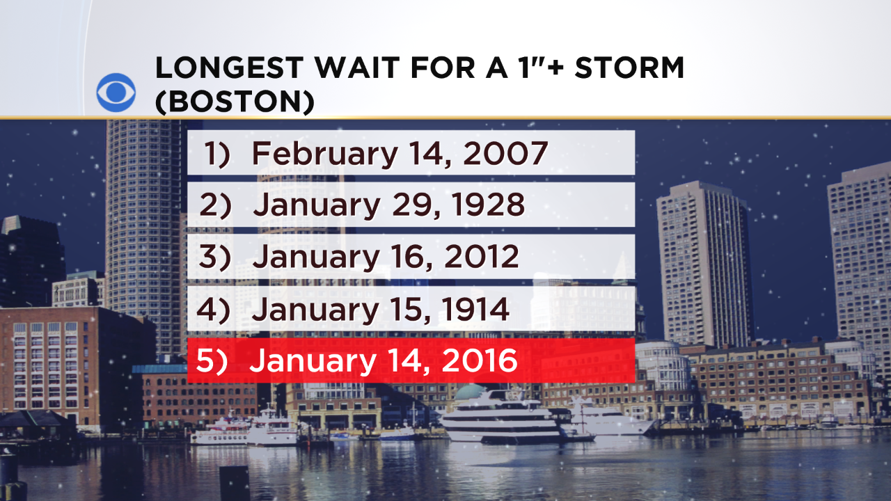
Waiting for a measly 1" storm. We haven't had a single storm produce at least an inch in Boston so far this season, and not expecting it Saturday. That means we'll move into sole possession of the 3rd longest wait on record.
First up, we'll keep a close eye on temperatures Friday night. Areas north and west of Boston will likely max out in the 34-38F range during the day, and then will have a chance to settle into the 28-32F range at night before the storm arrives. So there's an outside chance that this may begin as a brief period of freezing rain in a few localized spots west of 495 and along the east slopes of the Berkshires. This will be between 1am and 6am, so any impact would be limited with very few out on the roads. Also need to keep an eye on fog, which will develop as milder air starts to move in over our thin snowpack.
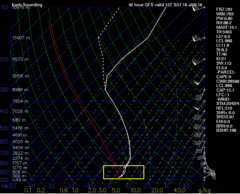
After that, there just isn't a whole lot of cold air available. This sounding (for Worcester) shows the situation well. While conditions are O.K. in the snow growth zone (-10 to -20C) and below freezing down to about 850mb, the layer below is quite warm. And for most of the area, that zone above freezing is more than 2,000 feet deep. It's just too much for a storm to overcome and produce any significant snow (or any snow, for that matter). I do think model guidance for surface temperatures is probably too high for inland areas, and that we'll see a coastal front develop. That means staying in the 30s along and outside of 128, but topping 40 east of it and for SE Mass. In that marginally cold zone we could see rain flip over to wet sloppy snow for a time. If this occurs it may look impressive for a few hours Saturday morning, but I wouldn't expect much accumulation thanks to the nature of the snow and the borderline temps.
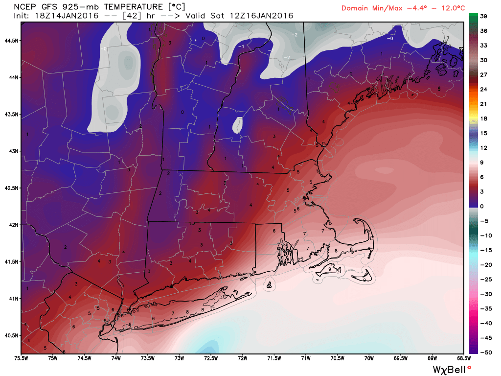
GFS guidance for temperatures at 925mb on Saturday morning. Just too much low-level warmth to overcome for decent snow opportunities. Source: Weatherbell
Outside of the wintry potential, the rest of us just get a good blast of cool rain Saturday morning...an excellent opportunity to sleep in. While the storm itself becomes quite 'deep' with its pressure dropping down into the 970s (millibars), there's no high nearby to really tighten up the pressure gradient. That means it gets gusty, especially near the coast, but nothing any New Englander would really take too much note of. We may see some E/NE gusts in the 30-45mph range at the coast...nothing that would cause any damage or coastal flooding.
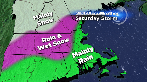
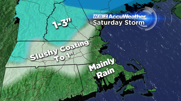
The rain and any wet snow tapers off from south to north midday into the early afternoon and temperatures will start falling back through the 30s region wide. We may even be able to break out into some sunshine before the sun goes down at 4:38pm. All told it's a pretty good waste of a storm if you're a snow lover.
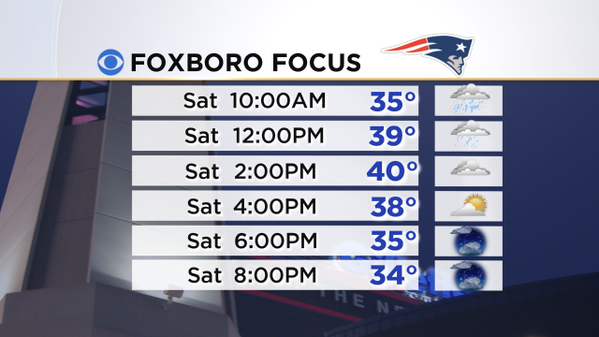
What does it all mean for the rowdy crowds in Foxboro? If you're showing up to tailgate as soon as the lots open (naturally, who doesn't?) there may still be some lingering rainfall around. We'll have the exact timing on that by Friday night. But the majority of the tailgate looks dry and breezy, and getting pretty chilly during the game with temps falling through the 30s and real feel temps in the 20s. Winds look to be 8-18mph from the northwest, with gusts to 20-30mph mixed in. May have a little impact on the kicking game, but not a huge one. That particular direction allows the wind to funnel in through the open end zone near the lighthouse and then swirl around inside the stadium.
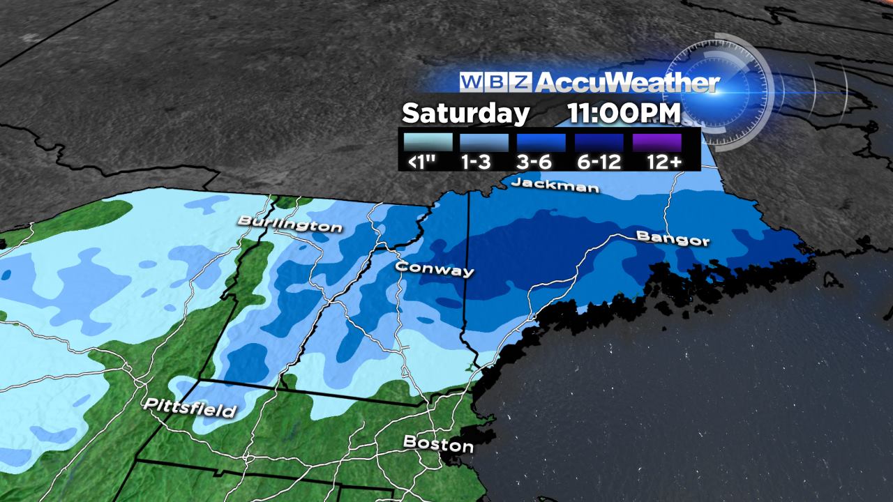
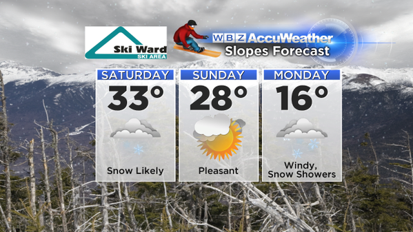
Now if you'd rather spend your weekend in the mountains than at Gillette, you're actually in luck! There should be enough cold air to keep this storm a mainly snow event for northern New England. So fresh flakes are expected for the Waterville and Mt. Washington valleys, as well as a *bit* of new snow in Vermont and another good pasting for much of Maine. No wash of rain and 40s/50s heading to the Canadian border this time around. There should also be a few rounds of snow showers/squalls on Monday and Tuesday next week, plus week-long cold settling in. So even without a blockbuster of a storm, there are several opportunities for snow and temperatures chilly enough to keep the snow guns running at an efficient clip. Finally, the fortunes of New England ski areas starting to turn around after a brutal start to the season.