Winter Arrives: Coldest Air Since February, Snow On The Way
BOSTON (CBS) - Okay, I'll admit it's a little strange. Everywhere I go and everywhere I look, people are talking about how last winter followed the same script as this one. To be fair, that's not entirely true. Last November was MUCH colder than this past one, and this December was MUCH warmer than the last one. However, our snow totals are about the same through the start of the new year. And here we are, looking at another chilly and mainly dry start to January.
Hmmmmm.....
No, we don't expect 100" of snow and brutal, record setting cold. But we certainly do expect more 'winter' in the final 2/3 than we saw in the 1/3, and a real taste of that arctic air is in the forecast after a few bucolic days to start 2016.
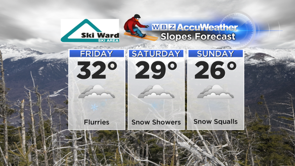
It's all good today through the weekend with highs near 40, 20's at night, and no issues so far as the weather is concerned. In fact, it's an ideal weekend to kick off the ski and snowboard season with fresh mountain snow and cold nights to keep the snow guns blazing. Hands down the best conditions of the young season in New England. Then we get to the good old fashioned arctic blast for Monday and Tuesday.
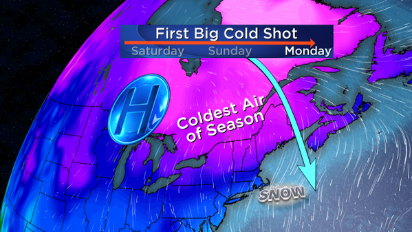
The air mass we're tracking will head south behind a potent arctic front Sunday night, dropping our 850mb temps down into the -15 to -19C range. Haven't seen much of that since last winter! It translates to highs in the 10's and 20's for Monday and Tuesday, which means it'll be the first back-to-back days below 30F since our absurdly cold February last year.
After a December filled with a record number of 50's (20 days topped 50F, a record in Boston) and even some 70's just a week ago, you can bet this may hurt a little bit. Wind chill will likely be in the single digits on Monday afternoon and evening as this air mass takes control. It also means our lakes and ponds are going to start growing some ice over the next 5-to-6 days - but be careful since it will likely not be anywhere near thick enough to go out on.
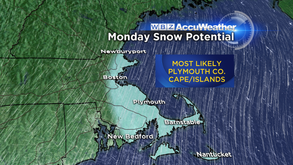
This air is cold enough to get ocean-effect snow cranking with a huge temperature differential between the air mass and the ocean. Right now, Boston Harbor is still sitting around 48F. All of our coastal waters are running well above average after an extremely warm July - December. We also haven't had any significant storm systems to churn up the waters. So with -18C air at 850mb moving over water that's about 9C, ocean-effect snow bands should push into the eastern shores of Massachusetts Monday into perhaps early Tuesday. These areas are often hyper-local and it doesn't mean widespread snow, but persistent bands could provide plowable snow for some communities.
Most at risk for some snow appears to be Plymouth County and areas down to the Cape and Islands. It all comes down to wind trajectory, and how this arctic high builds down out of Canada. Some of the snow could also scrape Cape Ann and Boston if the winds blow just right. But for now we're targeting the South Shore to the Cape for the best chance of accumulating snowfall. It's our first dip into biting winter weather with gusty winds, very cold temps, and snow in the air. Kids returning to school will definitely get use out of any new winter gear they may have received for Christmas!
This particular outbreak of cold looks to be a 2-day stay, with moderating temps for Wednesday and a warming trend into Thursday and Friday. After that the outlook is highly uncertain with lots of unknowns in the medium to long range. Signals have been wavering, but a developing +PNA (ridging over the West Coast into western Canada) should help keep a trough in place for the east, keeping big warm ups away and also increasing our storm odds. The next chance for a significant storm is late next weekend, but of course we're talking 8-9 days down the road so lots of time to see how things evolve. The vast majority of next week, outside of the ocean-effect snows, looks dry.


