Eye On Weather: What Does Winter Have In Store?
BOSTON (CBS) – Last winter, many people wanted to change the lyrics of "Let It Snow" to "Stop The Snow!"
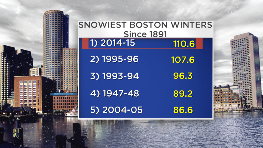
Boston's 30-day snowfall record of 94.4" ending February 21, 2015 decimated the previous record of 58.8" for the 30-day period ending on February 7, 1978! The weather outside was indeed frightful for four to five weeks but it actually was delightful for six weeks leading up to that apocalypse.
Compare that to the weather over the past six weeks. The anomaly has been even more astonishing.
Read: Eye On Weather Special Reports
Could we conclude that this amazing blow torch will lead to a worse weather crash ahead? Absolutely not.
GLOBAL FACTORS
It's all about the cast of characters, the sets and subsets of global factors in command. There is a myriad of global factors that influence seasonal climate forecasting for various locations. They include such indices as ENSO, the NAO, the QBO, the PDO, the PNA, the EPO, the AMO, the MJO, etc. The permutations in the phases of these numerous oceanic and atmospheric oscillations, the solar cycle, geomagnetic activity, recent volcanism, storm track data, fall temperature and precipitation patterns plus the extent of fall snow cover from Eurasia into western Canada and the ice coverage in the Arctic Sea all play a role. It is a veritable Rubik's cube and the finesse is figuring out all of the intricate turns and twists in the plot.
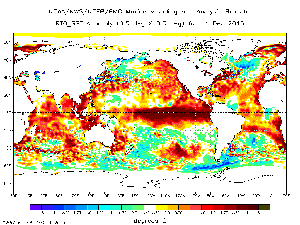
There is an amazing connectivity between the oceans and the atmosphere. Sea-surface temperatures play a key role in the placement and configuration of the jet stream during the winter season. The precise positions of the various pools of warmer and cooler than average ocean water ALL indicated an unusually snowy and cold winter for the Northeast last winter.
EL NINO'S IMPACT
This winter, there are some changes in those anomaly centers but a few are still flashing a cold and snowy scenario for the Northeast. However, the dominating factor this season is the presence of a strong El Niño which is manifested by the strip of much warmer than average sea-surface temperatures in the eastern and central equatorial Pacific Ocean. All El Niños are not created the same. The real wildcard in this winter's prediction hinges on the flavor of this El Niño. If the water in the eastern equatorial Pacific continues to cool and the warm anomaly of the water in the central Pacific becomes greater, it will produce a so-called El Niño Modoki.
This would lead to a colder El Niño solution for the southern and eastern portions of our nation. This suggests a challenging back-loaded winter as the polar jet stream delivers episodes of cold air drop out of eastern Canada and an active sub-tropical jet stream steers numerous storms over the southern states with some of them curving up the eastern seaboard and striking the Northeast. It is possible that the Mid-Atlantic region will have the most harsh conditions later this winter. History reveals that most of the higher impact East Coast storms occur in El Niño years. El Niño is projected to cycle to a weakening mode later in the winter as well.
"THE NOVEMBER EFFECT"
A great source for seasonal forecasting is studying weather conditions, global factors and corresponding analog years to see what actually happened. One clue that cannot be ignored is the "November Effect". Researching data back more than 100 years, warmer than average Novembers in the Boston area almost always lead to winter seasons producing less than average snowfall. The city's average snowfall is 43.9". The warmer the November, the less the snowfall.
For example, the mean temperature of November 2011 was a whopping 5.7 degrees above average. That winter, Boston received only 9.3" which is in second place for the least amount of seasonal snowfall. November 2015 was +3.9 degrees and this December currently is closer to a colossal +7 degrees. December will certainly end up in the top ten warmest Decembers in 140 years. The reverse verifies almost every single time as well. In other words, colder than average Novembers especially with snowfall yield snowier than average seasons. As an example, last November's mean temperature was 2.2 degrees below average with 2.6" of snow. The winter season turned out frigid with record-breaking snowfall.
HOW MUCH SNOW WILL WE GET?
In conclusion: This is the projection from the WBZ AccuWeather Team. A closely-matching analog year is 1957-58 which was a relatively strong El Niño year and Boston ended up with 44.7" of snow. Therefore, earlier, I was leaning in the direction of slightly above average snowfall but I am adjusting that downward to near or perhaps slightly below average snowfall for this winter.
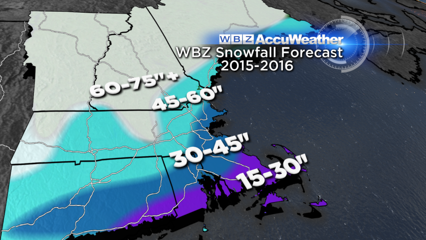
Thus, based upon the latest trends in temperature this month plus updated projections of some of the global indices going into January, we are comfortable with this snowfall map that was released as part of our Winter preview piece on the WBZ News on November 19. When that team discussion aired that Thursday night, Eric published this great blog, "5 Things To Know About This Winter." Check it out. It's a good read!
Despite what has been happening the past 6 weeks, I believe this winter will not mimic the wide open winter of 2011-12 when the temperature was much above average through the entire winter with little or no snow. An eventual weakening of the Polar Vortex should encourage more masses of cold air later in the winter yet the overall mean temperature of the winter will be closer to average rather than way below average like last winter. The active southern jet stream will link with the timing of some of this cold to produce assorted types of precipitation, not the pure powder snows of last winter. I am expecting average to somewhat below average snowfall for the ski resorts.
In the meantime, unless the weather pattern drastically changes in the next week, I think we'll all be Dreaming Of A White Christmas.
HAPPY HOLIDAYS & HAPPY WINTER!
Join the WBZ-TV Weather Watcher Network. Apply here.