Wind Now, Warming Later
Find Eric Fisher on Twitter and Facebook
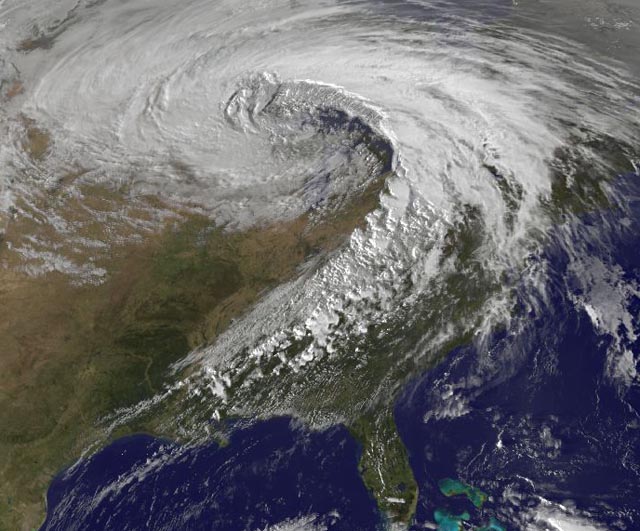
A large and powerful autumn storm blasts the Great Lakes and Midwest on October 26, 2010. This storm reached an extremely low pressure of 955mb. Source: NASA
Autumn is well known for great gales blowing across the country, and this week is no exception. I've heard the phrase 'Witch of November' bandied about these past few days - which is actually not something most meteorologists (that I know of) use to describe such a storm. It has its roots in some weather mythology, where people in days long ago used to say that a witch cursed the Great Lakes with its powerful October/November storms that would roar in with strong winds and huge waves. The phrase was also made popular by the Gordon Lightfoot song "The Wreck of the Edmund Fitzgerald" which makes reference to the Witch of November. That great storm brought winds gusting over 85mph and 35 foot waves to the lakes. This week's version was more run-of-the-mill...the type we see nearly every autumn.
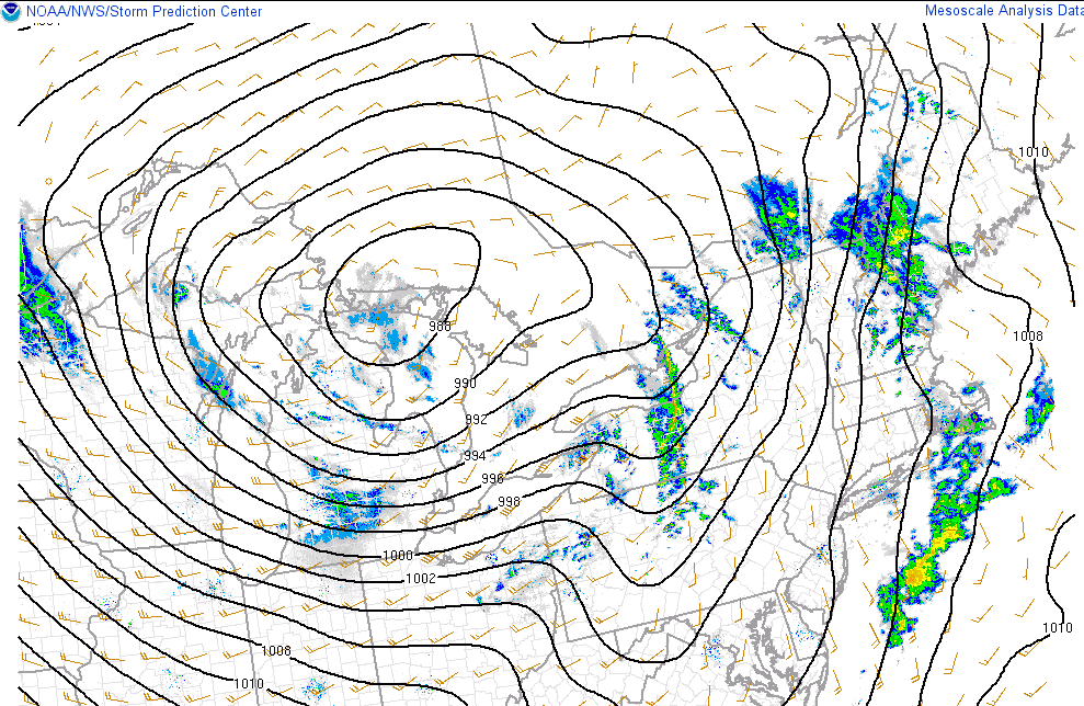
A strong storm for sure, but this week's low across the Great Lakes doesn't rank amongst the more impressive ones we've seen. There's often at least one such storm that develops every year. Source: SPC Mesoanalysis.
The more widely used name for such a storm is a 'Colorado Low' which is a system that undergoes rapid lee-side cyclogenesis, or in simpler terms becomes strong very quickly east of the Rockies. The classic Colorado Low track races the storm from the Denver area to the Great Lakes. These storms often bring dramatic changes in short periods of time, and we certainly saw that! The Des Moines, Iowa airport reported warm air, then a tornado, then snow in the matter of a few hours. That type of thing frequently happens with these events.
That same storm system impacts our weather today, but in a much simpler way. Wind! Plenty of it, as the storm reaches max intensity and a tight pressure gradient sets up over the Northeast. We'll see winds frequently gusting 30-45mph all day long (out of the west-southwest) which will continue to help defoliate our trees and will send your trash bins down the street if you don't grab them quickly after pickup. That gradient stays tight on Saturday as high pressure builds in, with more 20-35mph gusts (NW) on Saturday delivering chilly November air. Even on Sunday, as high pressure approaches, we'll keep gusting 10-20mph in the area.
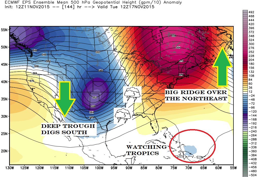
A look at what we're keeping an eye on next week.
Once things calm down, they really calm down here in the east. Another gigantic ridge of high pressure will set up shop over the Northeast and eastern Canada, keeping us bright and dry. Meanwhile, a very deep trough will be digging in across the west. The pattern we're now in has barely been seen in years! A jet stream ridge in the west and a trough in the east had been the dominant set up for several years. That's why California is dealing with drought, and most of the west has been shattering heat records. But now things are changing due a near-record strength El Nino. A storm parade is lined up for the west and the middle of the country, while our temperatures will be warming up and Arctic air stays bottled up.
The setup isn't perfect for a true November torch here in New England. High pressure to our south on Monday will give way to a new area over the Canadian Maritime by Tuesday-Wednesday. What that means for us is more of an on-shore component to our wind, which in turn keeps our temperatures from really taking off. Even still, temps well into the 50s are expected to start the week, and as winds go more southerly we may have several days reach the 60s late in the week/next weekend. For context, the average high in Boston by next Friday is 50F, while the average low is 37F.
This next trough will bring all manner of stormy/severe weather for the Plains and Gulf Coast states next week, but that trough will have a tough time moving toward us. That holds off the rain chances until at least Thursday, and as another piece of energy digs in late in the week we'll push more mild air up along the East Coast. There's an outside chance we'll be in the 60s for our tree lighting at Faneuil Hall Saturday night!
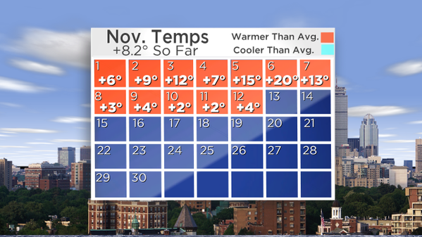
Not a single blue square (day of below avg temps) so far this month. Looks like our only chance is Saturday.
So when you look at the month as a whole, we're well on track for a very warm November. We still haven't managed a single day of below average temperatures. It's the complete flip-flop of February, where every single day was below average except one. It looks like our only shot to do it will be Saturday (expected high of 48, low of 39). After that we may stay above all the way through next weekend at the very least. There are also indications that December is going to be a very mild month for us here in the Northeast and in the Midwest. The long-range models are pointing to a lack of Arctic air making its way down into our part of the country. This is not surprising - El Nino years tend to bring warmth in late fall/early winter. If we get into the cold blasts and snow, it will likely be delayed compared to 'typical' winter seasons.
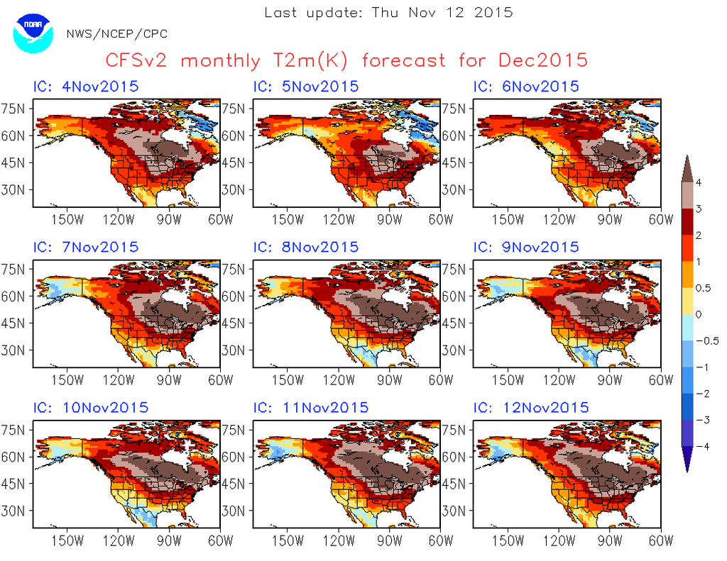
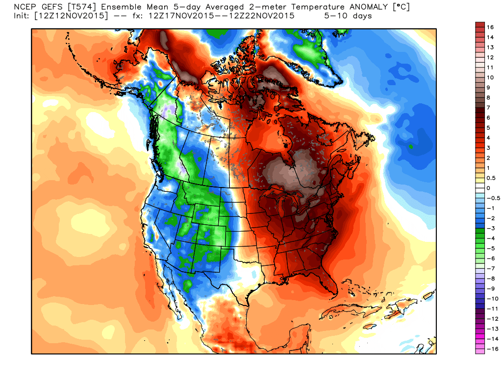
One model's look at December temperature anomalies. Definitely not looking too harsh in Canada! And it appears like another mild December may be headed our way in New England, too. Source: Michael Ventrice, WSI.