Hurricane Joaquin: Moving Out To Sea, But Raw Weekend Ahead
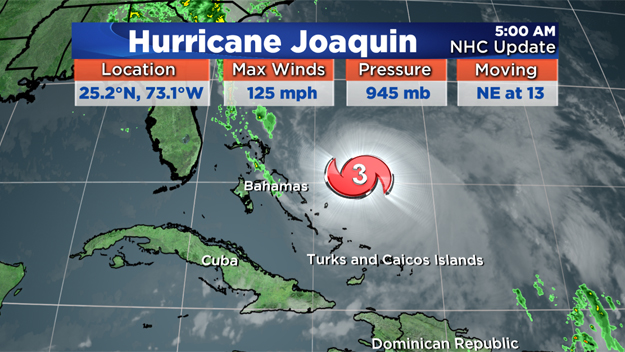
BOSTON (CBS) – First, the latest on Hurricane Joaquin. This is still a major Category 3 hurricane with a maximum wind speed of 125 MPH. The storm is starting to pick up speed as it moves northeast at 13 MPH and away from the Bahamas.
View: Hurricane Tracking Maps
The latest track shows the storm will not hit the east coast, thank goodness! As the storm passes by (although hundreds of miles away) Monday into Tuesday, here in New England we will experience high surf and strong rip currents.
Our local forecast today is similar to what we have had for a couple of days now - windy, dreary, chilly & drizzly. A few light showers may also affect your afternoon plans.

We are north of a stationary front and as long as that is still there, we keep the nasty weather. That front slowly moves out Monday and our weather slowly improves.
Check: Weather Blog | Current Conditions | Share Photos
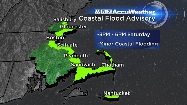
Highs this afternoon top out in the lower 50s with areas of drizzle and strong wind. The wind gusts may peak at 50 MPH through 3 p.m. on Cape Cod and the islands. That is where there is a wind advisory. A coastal flood advisory will be in effect from 3 p.m. to 6 p.m. today due to the high tide and strong winds. Minor flooding, splash over and beach erosion are all possible.
Sunday we are expecting another cloudy, drizzly, chilly & breezy day, although, we may see some bursts of sun inland. An onshore flow keeps the drizzle and clouds around along the coast.
Monday into Tuesday, temps slowly warm and the sun appears again. By Wednesday, we jump to above average highs around 70 with full sun. No major weather issues are expected for the end of this next week.
Follow Pamela On Twitter @PamelaWBZ4


