Hurricane Joaquin: Confidence Growing For Out-To-Sea Track
BOSTON (CBS) – Good news! Confidence continues to increase for an out-to-sea track for Hurricane Joaquin.
After a week of playing weather model pinball, there is finally some agreement on an eastward track, taking the center of Joaquin west of Bermuda and well east of New England early next week. In fact, earlier this morning, for the first time, Joaquin begin to move slowly to the north, away from the Bahamas.
View: Hurricane Tracking Maps
Talk about a long week. The Bahamas have been taking the brunt of this massive hurricane for days now. It has literally been wobbling around, waiting for some sort of steering current in the atmosphere to give it a direction and a purpose. Tonight and into tomorrow we will finally see an obvious acceleration to the north. That leftward hook that many models were predicting it would take earlier this week, into the Mid-Atlantic, is no longer on the table.
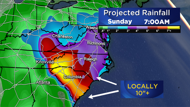
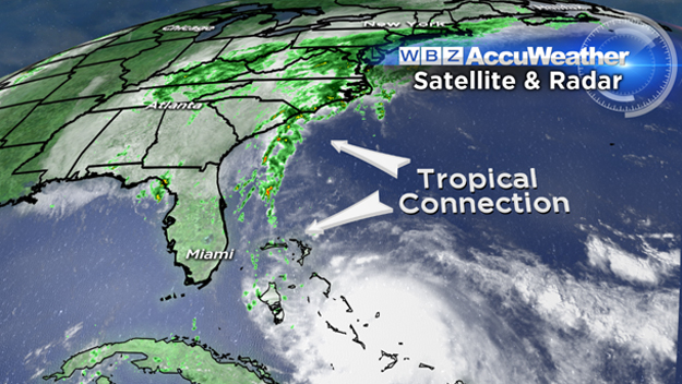
Unfortunately, a good portion of the East Coast is still going to get hammered by wind and rain over the next several days. While not directly related to Joaquin, tropical-like downpours will cause massive flooding, especially in the Carolinas where a foot or more of rain could fall through Sunday.
This is mainly due to a deep, digging trough in the Jetstream along the East Coast, which will combine with a stalled out weather boundary currently sitting just off the coast. Add to that an infusion of moisture from Joaquin hundreds of miles away and you have what looks to be a very serious situation about to unfold.

Thankfully, here in New England, it appears we can breathe a sigh of relief. Don't get me wrong, the weather this weekend will not be pretty. The strong northeast winds will continue through Saturday, especially along the coast. There will be one final round of minor coastal flooding Saturday afternoon around the 4pm high tide.
All of Southern New England will remain socked in the clouds and occasional rain and drizzle on Saturday. By Sunday, the winds will slacken a bit and the air will begin to dry out. There will still be a good deal of cloudiness. I don't think we will see more than some breaks of sun here and there.
Searching for sunshine? Head north! Northern New England should see a good deal of sun this weekend and the foliage is just starting to burst! The fall colors got off to a slow start this year but are nearing peak in most of the higher elevations of Vermont, New Hampshire and Maine.
Check: Weather Blog | Current Conditions | Share Photos
One last word on Joaquin. It will likely make its closest pass by our latitude on Monday. It is forecast to be several hundred miles off of Nantucket. While we will be nowhere near the wind and rain shield, there is some concern for large ocean swells and rough seas.
Let's face it, the water off our coast is already riled up from a week's worth of stormy weather and wind. Throw a hurricane into the mix (even one that is 300 miles away) and it will only prolong and perhaps worsen the situation.
Not expecting any coastal flooding, the tides are lowering from an astronomical perspective. But, for those with marine interests (going on a cruise?) the seas will be excessively rough early next week.
Looking forward to getting back to those "quiet" fall days soon.
Follow Terry on Twitter @TerryWBZ