Chances Increasing Hurricane Joaquin Will Make East Coast Landfall
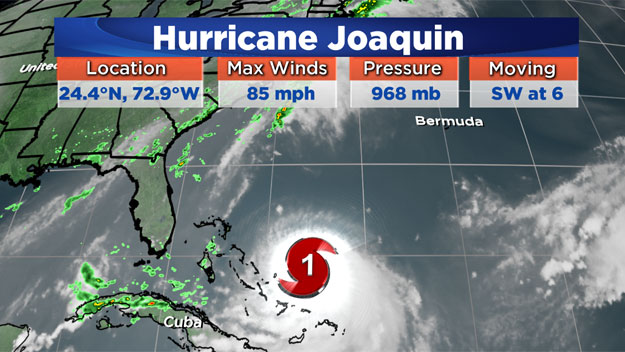
BOSTON (CBS) - It has been a historically quiet year for hurricane activity in the Atlantic. This comes as no surprise as this was forecast to happen, largely due to a strengthening El Nino. As we head into the month of October, we have had no hurricanes anywhere near the United States this season. Until now that is... Joaquin has been sitting just north of the Bahamas feeding off of some very warm ocean waters and as of this morning, strengthened into a hurricane. Just the third hurricane of the season, Joaquin is already closer to the U.S. mainland than any other storm of its size this year. And chances are increasing that it will be making landfall along the East Coast this Weekend.
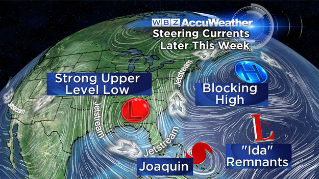
No hurricane track/intensity forecast is simple, but this one has proved to be an absolute bear. The atmosphere is in the process of twisting itself into all sorts of a mess right now. The normal west to east flowing Jetstream is going to resemble a pretzel come this Weekend, something not all that uncommon in spring and fall as the atmosphere begins to realign itself preparing for significant changes.
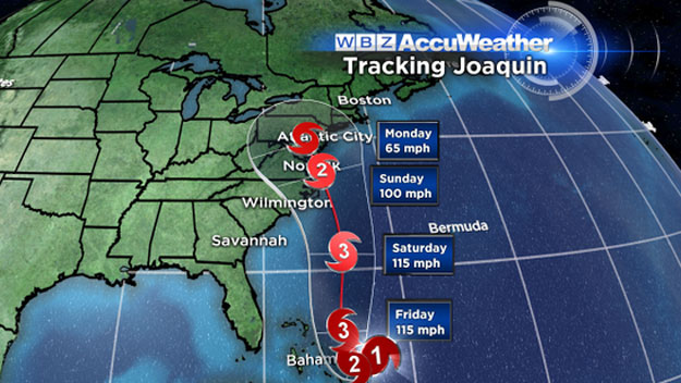
Joaquin isn't going anywhere fast, at least not for a few days. There really aren't any significant steering currents around it, so it will just tend to drift west-southwest for the next 24-48 hours or so. Finally, by Friday, it will likely begin to feel the effects of the Jetstream over the U.S., which will be digging a major "trough" in the southeast U.S. It now appears likely that trough will dig so deep, down into Florida, that it will likely capture and "draw in" Hurricane Joaquin towards the East Coast. Models are beginning to converge on a solution which would suddenly and violently pull Joaquin to the northwest on Friday and Saturday. Best guess right now for landfall location would be around Coastal North Carolina early on Sunday morning. But I cannot stress enough that there are several atmospheric factors at play here all of which could change and lead to a much different final track for Joaquin. In fact, one of our more trusted weather models, continues to show a much more "out to sea" solution, which cannot be ignored. Under this scenario, there would likely still be a band of heavy rain affecting the Mid-Atlantic/Carolina's but they would avoid the strong winds and main impacts from Joaquin.

If the forecast of a North Carolina landfall is correct…what does that mean for them and us? This could be a big blow for folks in North Carolina. Joaquin is not likely to diminish much at all in strength before landfall, meaning it could come ashore as a cat 2 or even a major cat 3 hurricane. (We haven't had a major hurricane make landfall in the U.S. since Wilma in October of 2005) There would obviously be a great deal of wind damage in Coastal Carolina, but the biggest impact could be the torrential rainfall. Under this scenario, there could more than a foot of rain in parts of the area (from Virginia to South Carolina). Heavy bands of rain would pound the region Thursday and Friday, before Joaquin even arrives. Combine that with a direct hit from Joaquin on Sunday and you have a recipe for a very serious and potentially life threatening situation.
For us, a landfall in North Carolina would have very little effect on our weather. For the next few days we are sort of in a call zone. The heavy rain from this morning will have largely shifted offshore and stalled along a frontal boundary. This boundary will likely push back to the west, bringing some rain back into Southern New England on Friday. But, we would be nowhere near the actual circulation and heavy rain associated with Joaquin. It is likely that the remnants of Joaquin would eventually make their way north, perhaps bringing some tropical downpours here early next week. However, it would no longer be a tropical system and would not look anything like what it did when it made landfall.
I think the most important takeaway from this blog would be to stay tuned. The next 48 hours will be very important in determining the strength and eventual track of Joaquin. In the meantime, coastal residents should be prepared for some minor flooding over the next few days. Tides are astronomically very high and a persistent, gusty onshore wind will make life along the Coast rather miserable the rest of the week. Please note, this is unrelated to Joaquin, but still should be taken seriously. Winds could gust to 50mph at the Coast and over SE Massachusetts, leading to some powerline/tree damage on Thursday and Friday.
Follow Terry on Twitter @TerryWBZ