Drought Update: Dry Times Continue
It's the time of year when your lawn usually makes a strong resurgence as summer heat winds down and the sun angle becomes less harsh. But not so this September.
It's been tough to locate a raindrop in southern New England, much like it was in August. We've had just enough rain here and there to keep us out of big trouble (reservoirs are still in fine shape) but certainly not enough to keep the landscape green or rivers flowing at a healthy clip.
The good news is that we're leaving the growing season. Many crops are starting to wind down as decreasing daylight begins their demise. And if you're an apple, you're loving this! Drier weather can help produce a more intense flavor, and anyone who's driven by an orchard can see that most of the trees are absolutely laden with fruit this year. So a dry stretch isn't quite as harmful as it can be in late spring/summer. Evaporation rates are lower now, and our concern over the lawn and garden is likely not as strong.
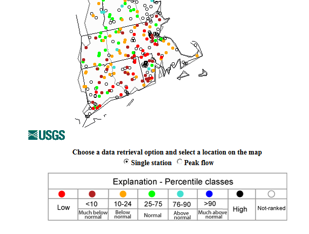
The lowest streamflow levels right now are across southeastern New England, where rain deficits have been the biggest. Note all the dark brown dots indicating much below average levels. Source: USGS
On the bad news side of the coin, the water table is dropping to very low levels. Some wells and streams are into the bottom 10th percentile. I've heard from some towns that their wells run dry if they run irrigation in the yard, and there are bans/restrictions in place for numerous communities. The latest drought monitor, which is updated every Thursday morning, has parts of the area in 'Moderate Drought' and the rest 'Abnormally Dry.' Precipitation deficits range from about 5-10" for the year across the region, with a few locally higher departures from average. And yes, that includes snow! Most of the storms we had in our record winter were so 'dry' (think fluffy snow) that they had very low water content, even if the flakes stacked up deeply.
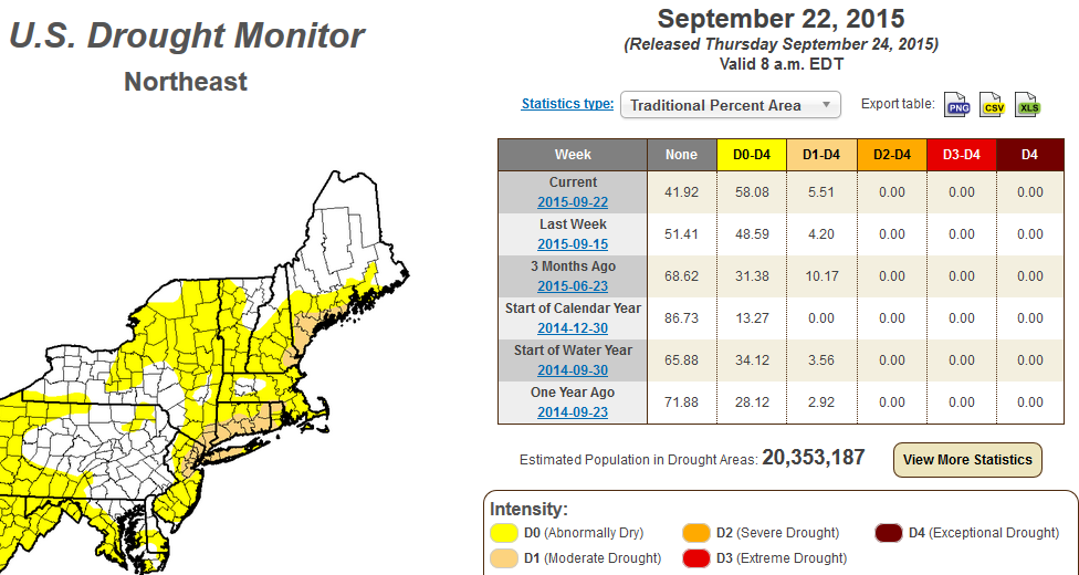
Source: NOAA's Drought Monitor
September won't be close to a record dry month (we're in 29th place as of this writing) but it will definitely be a warm one. I'm projecting a Top 4 warmest September on record, which has helped to dry things out further. This combo is also going to have an impact on our foliage. It's a good bet that it may be a bit more dull than usual, and feature more leaf drop from stressed out trees. That's not to say it's going to be an ugly fall - a soaking wet pattern is actually worse for the fall colors than a dry streak! But I think better color will likely be found north where it hasn't been quite as parched.
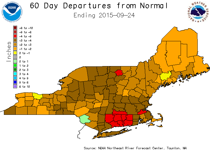
The last two months have been exceptionally dry, especially in southern New England. The worst drought conditions have been found across southern CT/RI. Source: http://www.weather.gov/nerfc/watersupply
If you've been following all the California stories and wondering if this is the start of a major problem for us, I'd say that such an outcome is very unlikely here. Major droughts are a normal part of the western United States and have occurred numerous times in its history. That's not to be insensitive to their plight, but just to point out that it's not something that should be unexpected.
Here in the Northeast, we don't have the same kind of geological past. Weather tends to balance out here, and indications are for a stormy winter in these parts. In the short term, there won't be a lot of relief though. We may nab a couple of showers Monday and a few more on Wednesday, but nothing that's going to put much of a dent in the dryness.
Farther out into October, we may have a fighting chance for some East Coast rain. It looks like a major ridge is going to build in the middle of the country and produce a lot of autumn warmth in the process. We'll be on the far eastern edge of this ridging, which should keep us mild but not as strongly above average as we were in September. Being in this position also puts us in play for some more frequent rain chances (the big ridge for most of this month has been built up over the Northeast and eastern Canada, blocking storms from approaching). We may not be able to really tap this wetter pattern until mid-October when deeper troughing digs into the east. It's not the most desirable outcome to stare at burnt out grass on the side of the road, but I don't believe this is something that's going to last for too much longer.
Just enjoy the sunshine for now and bottle it up for the rainy days that are sure to come before too long.
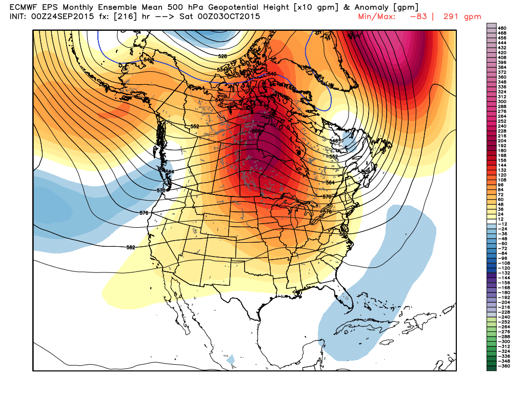
ECMWF weeklies showing a monstrous ridge developing and dominating the Lower 48. This should produce a very warm October for CONUS. Source: Weatherbell