Goodbye Heat, Hello Rain!
Find Eric Fisher on Twitter and Facebook
The hottest days of the year have come to a close after setting several records across southern New England. And in their wake, your lawn is probably crying uncle. There has been very little in the way of organized rain for several weeks, thanks in part to a low-impact tropical season. A lot of our late August/September rain can be produced by the remnants or direct strike of a tropical system. With the action (so far) staying out to sea or being sheared apart, all we've managed are a couple hit miss storms. With a little luck we'll make up for lost time over the next few days.
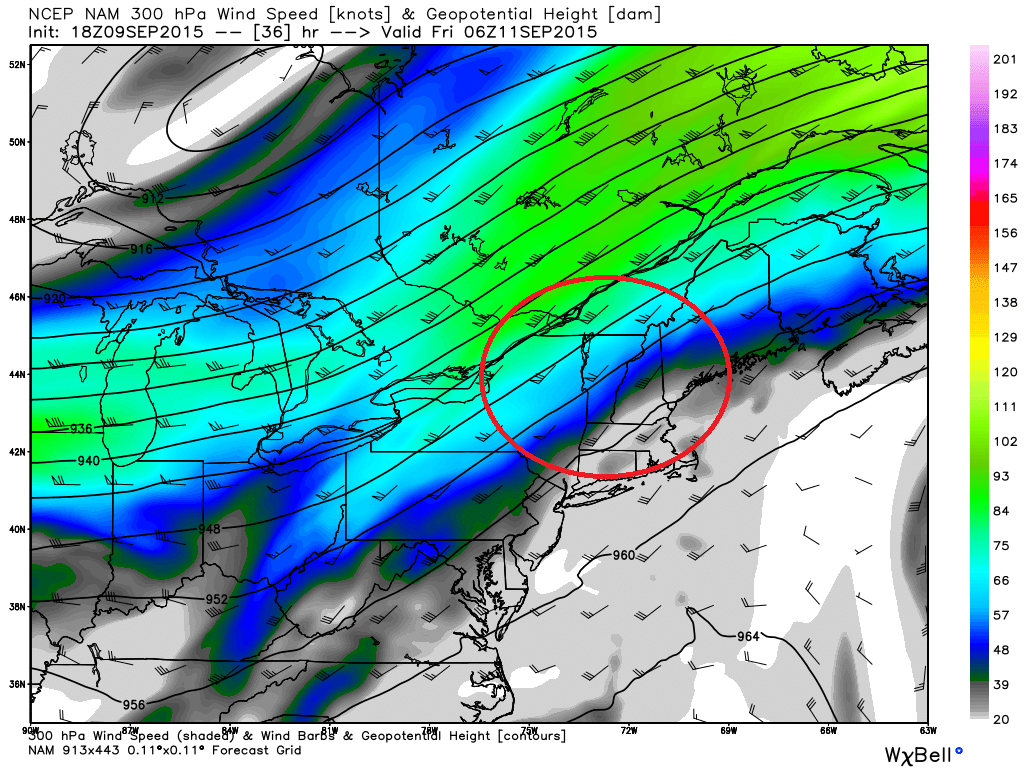
NAM model showing the 'right entrance' region of a jet streak, helping to provide more lift in the atmosphere Thursday evening. Source: Weatherbell
The tricky part of Thursday's forecast is nailing down the exact axis of concentrated downpours and highest rain totals. A quasi-stationary (meaning - barely moving) front will be draped across the region. Meanwhile, we have a wave of low pressure riding up from the south, and have a jet streak getting into position across New England. These 'jet streaks' are areas of the jet stream with extra-strong winds, and when we're in the right entrance region of one (like Thursday) or left exit region, it helps to make air rise. It's actually an early preview - this is the kind of setup we see more in the late autumn or winter! All these factors guarantee that it's going to rain quite a bit...somewhere. But where's somewhere?
Models have been all over the place when it comes to amounts and the exact placement. But climatology would tell us that the most likely spot will be north and west of a line from Providence to Boston. We may manage one early salvo of downpours/showers in SE Mass to kick things off during the morning commute, but the more widespread downpours will get going after lunch and start to shift to the northwest. I think for most of the afternoon, the best chance of heavy rain will be across western New England and central MA/southwest NH. This is also where air will be coolest - staying in the 70s. Local totals over 2" are not out of the question that with such tropical moisture streaming up from the south. Farther to the southeast, there could still be some scattered downpours and showers. But the concentration of them should be lower, with the lowest chance of heavy rainfall over the Cape and Islands. It's a double edged sword though - it's also in SE Mass that thunderstorms are most likely. Breaks of sun should help get temps into the low 80s here, so we'll be on the lookout for any lightning issues.
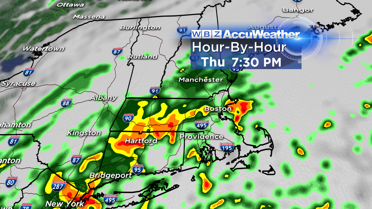
As we head into the night, the axis of rain should start moving east again as low pressure strengthens. Batches of heavy rain will work their way into eastern MA, and this is also when the Cape/Islands have their best chance at some decent rainfall. That rain will linger into the Friday morning drive, before drier air slowly moves in during the afternoon. It looks like we should be able to get in some late day sunshine, and Friday evening plans look safe from rain. All told, most of the area should end up with 1-3" of rain for the whole event, Wednesday night through midday Friday. The lowest totals will likely end up toward the Cape & Islands. While localized flash flooding may be an issue in a few urban areas, streams are so low that any kind of stream/river flooding looks out of the question. Also notable will be the temps - staying in the upper 60s to low 70s! Nearly a 25 degree swing when it comes to daytime highs.
So how about the elephant in the room - the Patriots home opener. It's a huge night. We just went through 8 months of deflategate rubbish. Brady has been freed. People want to get rowdy and enjoy hoisting the spoils of the 2014-15 season: a championship banner in Gillette. No doubt, the forecast here is a tough one. We all know from past interviews that BB doesn't have much love for the weather, nor does he care what Mother Nature decides to do. That being said, this one is all about the fan experience. No one wants to sit in a sheet of tropical rain during the pre-game ceremonies and kickoff.
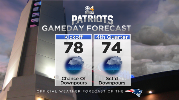
Right now, I'm hopeful that a window of mainly dry weather could potentially open up in the Foxboro area for the early evening. That axis of heavier rain mentioned above should set up NW of Foxboro. Now we'll still be working with a tropical atmosphere, so some pop-up downpours cannot be ruled out. You'll definitely want to bring rain gear for the tailgate and game, just to be prepared. But we should be able to miss out on consistent heavy rain that could really mess with the celebration. The one big question to me is - will there be lightning? Instability doesn't look too impressive, but there's just enough to keep lightning in play. It'll come down to luck of the draw whether or not some lightning develops in the vicinity of the stadium during the game. Always a good idea to download our weather app, which tells you when lightning is nearby! Fingers crossed the only thunder we hear is from the fans after a Patriots touchdown. Winds aren't expected to be a big player, unless a storm develops over the area. Temps will hover in the 70s and muggy conditions should hold on through the game.
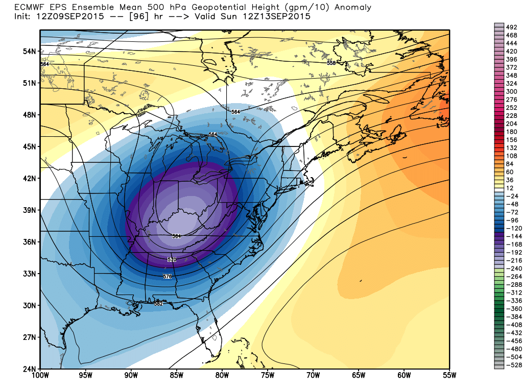
Anomalous trough digging down into the Midwest/Southeast will bring much cooler air to the east, and also help an area of low pressure to develop and move up the coast. End result is another round of rain on Sunday! Source: Weatherbell
After a reprieve on Saturday, another system is going to make a run at us on Sunday. This one could bring areas of rain and perhaps some embedded thunder for the second half of the weekend. Not only that, but onshore winds should keep high temps near 70. That's a far cry from the mid 90s many saw this week! So if you want to make some plans this weekend aim to be outside on Saturday, and enjoy a day of football and good food on Sunday. Between these two storms, everyone should see *at least* an inch of rain - which is more than most have seen for almost a month. It's a chance for the lawns to recharge and hopefully salvage the foliage season from a potentially dull show.
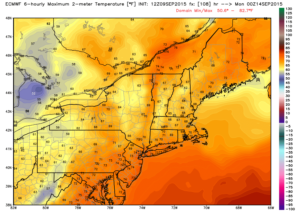
Model guidance for high temperatures on Sunday...there you are, fall. A cool end to the weekend before a warm-up returns next week. Source: Weatherbell