First September Heat Wave in 30+ Years?
Find Eric Fisher on Twitter and Facebook
A summary of reactions to weather over the Labor Day Weekend:
Saturday - Wow...this is incredible! Absolutely perfect out. That kind of air that you barely notice is there.
Sunday - Probably shouldn't have gone on that hike...getting a bit warm out here. But what an evening...great BBQ. Man I don't want summer to end.
Monday - Okay one more beach day is cool. Water is refreshing. Back to work tomorrow how's the forecast look....oh no.
Warm weather is a wonderful staple of summer, but for a few reasons it just doesn't mix as well with post-Labor Day life. Everyone is entering their fall routines. Vacation days are drying up. Kids are back to school, and teachers are trying to keep everything going smoothly with overheated classrooms. Afternoon sports get a little harder to manage to keep everyone safe. The 80s and 90s that felt great after a long winter start to become a little more of a nuisance. This is probably how at least a few of you are feeling on this torch of a Tuesday.
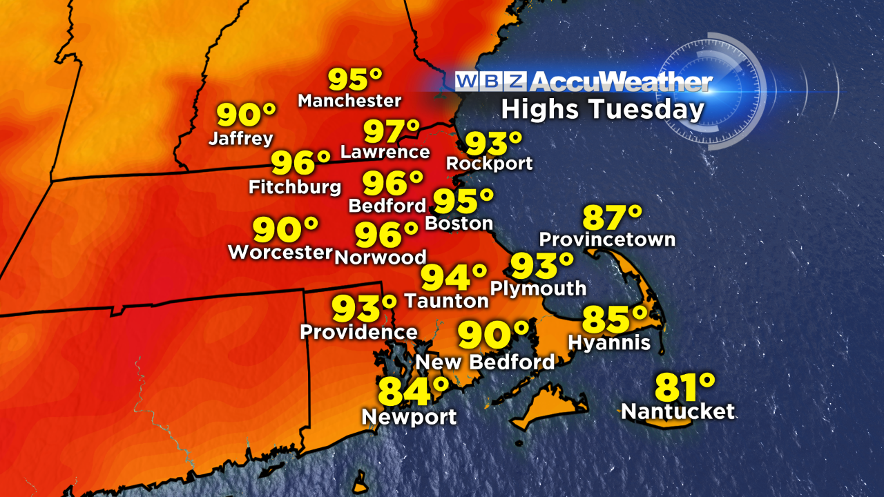
It's been an odd weather year for sure, and we kept the trend going with Monday becoming the hottest day of the year so far in Boston (93F). Today will in all likelihood top that mark, going all the way up to the mid 90s! Late summer heat is not too unusual. We had 90s to start September last year. The thermometer went all the way up to 97F on September 11th of 2013. We touched 95F in September of both 2010 and 2007. It can happen. But heat waves are a little more rare. An official heat wave is 3 or more days with temps reaching 90 degrees or warmer. The last one to fully happen in September was all the way back in 1983. So continuous stretches of very hot weather are more exceptions than rules.
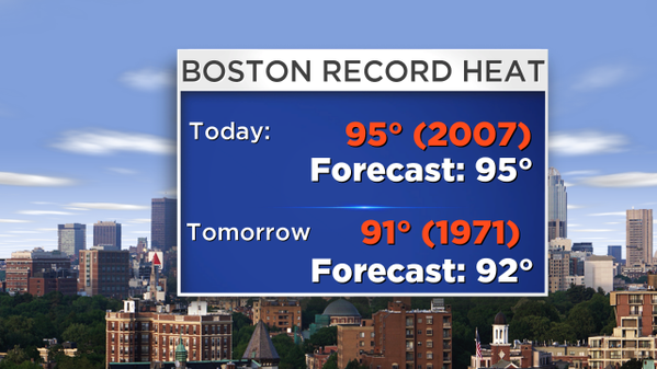
On top of that, we may be able to snag a couple of record highs today and tomorrow. We haven't set a single record high in all of 2015, so we'll see where the cards fall. Today's is a tough one to reach at 95F. But I do think we have a pretty fair shot of getting there. Tomorrow's is 91F, and we will again be in the ballpark. So if we get an official heat wave AND set a record or two in the process, this will indeed be an impressive (although not exactly enjoyable) few days.
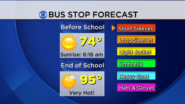
The biggest impact will likely be on schools and after-school sports, as every single district will be back in session this week. Many classrooms lack air conditioning, and with rising humidity this is going to be uncomfortable at the very least for students and faculty. You'll definitely want to make sure the kids are prepared with lightweight clothing and not that brand new fall sweater they picked out at the store to get ready for the new year. Plus, coaches should keep a close eye on students on the ball fields after school. Mid 90s and muggy conditions should produce heat index values near 100F, which can be dangerous when taking part in strenuous activity.
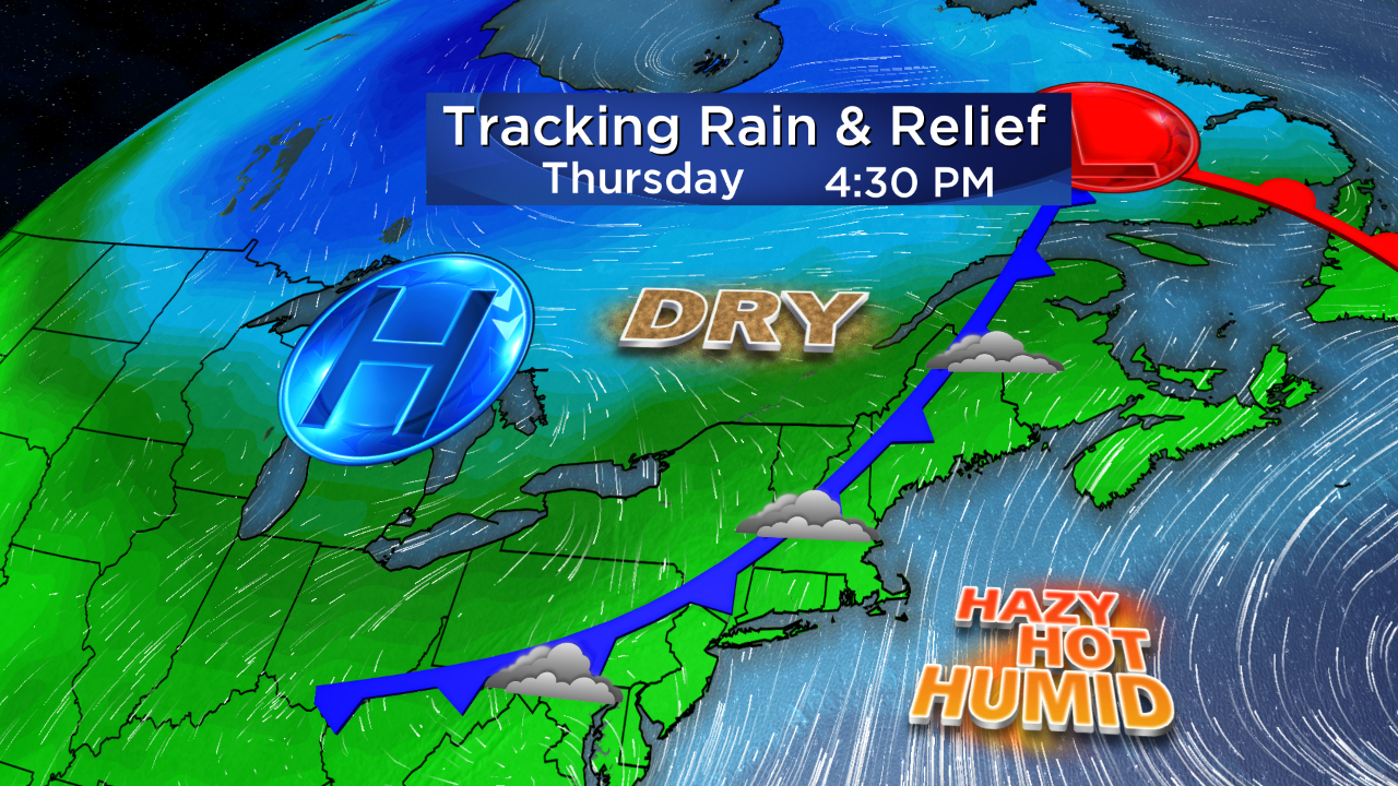
The worst of it will be Tuesday and Wednesday, but we'll start to see some relief heading our way on Thursday. A cold front will be approaching from the west, and will bring increasing clouds and chances for downpours during the afternoon/evening. It won't be cool per se - highs will still be in the 80s and humidity will be very high on Thursday. But the 90s will go away and the less direct sunlight should help a bit. Once the front moves east on Friday, we'll get into the drier air and much more seasonal temperatures. Highs will likely stay in the 70s Friday through the start of next week with lower levels of humidity. There's a decent chance this may be our last streak of 90s until 2016.