Week Of True Summer Weather
You can be on Team Winter, Team Summer, or in the starting lineup for spring or fall.
We all have our favorites and that's what makes New England great.
So far, Team Summer (of which I'm a casual fan but not a true fanatic) has been on a bit of a losing streak. June was cool, July has been a mixed bag, and Triple H weather has only come in fits and spurts.
To raise team morale, I give you this week's weather.
Monday was a slow transition into this classic July stretch with warm air and scattered storms. The action was an 'air mass' thunderstorm kind of day, where pop-ups develop where there's enough instability. They have these types of thunderstorms all the time in the summer across the southern U.S., and they're similar to watching a pot of water boil. In other words, convection. If you watch a pot of water, you'll see tiny bubbles form on the bottom first. Those are the starting points for thermals of buoyant air inside the pot (which you can think of as the troposphere). Forecasting exact locations of pop-up storms is difficult, because it's the same as trying to forecast which of these bubbles will race to the top first (a thermal current that's the same as rising air around us on a summer day which produces towering cumulus, then cumulonimbus, and the end product of a towering thunderstorm). But it sure is fun to watch them grow! We had some great viewer photos of textbook cumulonimbus on Monday.
You can spot the cold pool of air aloft over eastern New England which should help increase lapse rates when combined with daytime heating. Result: Some towering boomers developing after lunch. Source: Wright-Weather.com
So what's on tap Tuesday?
After some morning clouds and fog we'll be off to the races with highs in the 85-90 range. If your town manages to hit 90, you'll have a great shot at an official heat wave Tuesday-Thursday. Dew points will stay well into the 60s/low 70s so it will be plenty muggy and a steamy summer day. We're also keeping an eye on a disturbance that will rotate down from northern New England during the day. With heat and humidity in place, it won't take much to touch off scattered showers and thunderstorms once we hit the midday hour. The coolest air aloft and best forcing looks to be over eastern New England, so the highest risk of storms should be along or inside of 495 with more isolated activity west of that line. Any storms that develop would linger into the early evening (8pm or so) before falling apart with the loss of daytime heating, and could feature some damaging wind gusts, lightning, and small hail.
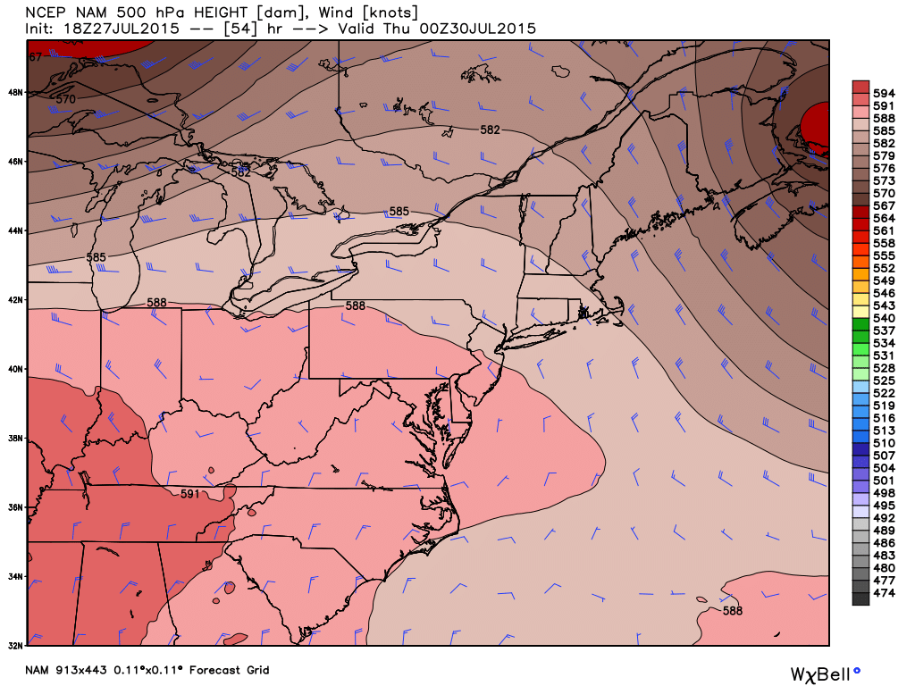
Ridge at 500mb taking up residence over New England on Wednesday should help put a cap on any widespread thunderstorm activity. Source: Weatherbell
On Wednesday we'll take a bit of a break from the storms as brief ridging of the jet stream moves in. It will be so hot out that we can't rule out an isolated afternoon storm, but they should be few and far between. The best chance of seeing one would be along a sea breeze boundary that may set up in and around the 128 corridor. Highs will top out mainly in the low 90s, with some 80s across the Cape & Islands. Humidity will be noticeable but not oppressive (over 70F)...that being said the AC will likely be cranked.
Thursday the next cold front approaches from the west and should bring some late day storms. The exact timing isn't clear just yet, but it looks like the highest risk would spill into central Mass by mid/late afternoon and head east from there into the evening. Depending on how much cloud cover from the previous day's storms spills into New England, we should be able to top 90F again in most towns. Humidity will be up a notch with dew points around 70F - a sweltering summer day.
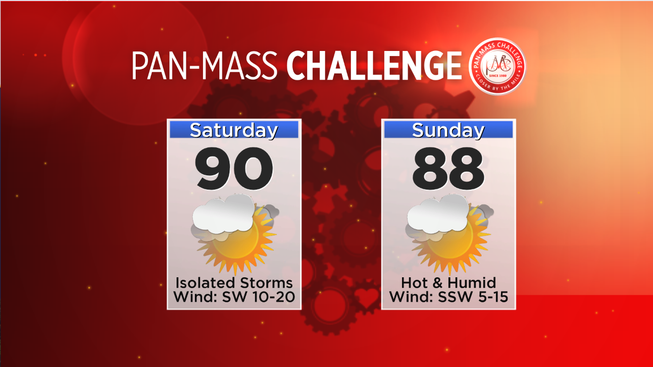
A little relief moves in for Friday from the humidity standpoint, but it still looks plenty warm with highs well into the 80s during the afternoon. It also looks like a dry day between disturbances. There are hints of a weak front in the vicinity this weekend, which may be able to touch off a couple thunderstorms on Saturday/Sunday afternoon. These will be those hit or miss pop-up variety storms, so a particularly stormy weekend isn't looking likely at this point. But the heat should continue with highs near 90F both Saturday and Sunday. Pan Mass Challenge riders will need to stay hydrated in a setup that's a complete 180 from last year (cold and pouring rain). We'll be keeping a close eye on that end of the forecast all week. In any case, it's a good stretch for tomato plants but perhaps not so much for your electric bill. Always give and take when it comes to our weather.
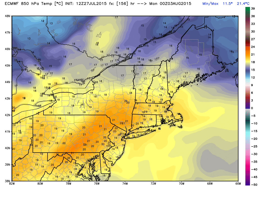
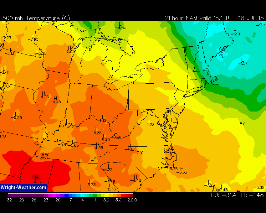
Plenty of warm air still in place this upcoming weekend with temps at 850mb in the +15C to +19C range for Saturday and Sunday. This should translate to mid 80s-low 90s at the surface. Source: Weatherbell